The Gorge Trail at Stony Brook State Park in Dansville, New York is a moderate 0.8-mile one-way hike that leads through the Stony Brook gorge and passes a multitude of scenic waterfalls and includes a beautiful stonework footbridge and trail.
Trails
This hike follows one named trail: Gorge Trail (blue blazes).
Swimming Prohibited
Swimming (along other activities) is strictly prohibitted on this trail. Despite the beautiful pools of water, none of them are permitted for swimming. If you're looking to swim, you can do so when a lifeguard is present at the swimming area located at Lower Stony Brook Falls (behind the restrooms)
Hike
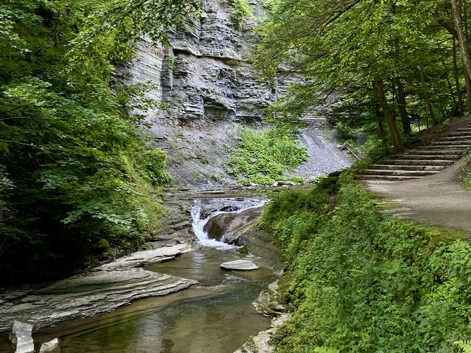
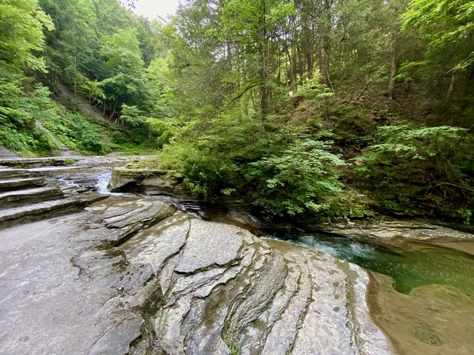
This hike begins at the main trailhead area at the park, located on the east side of the large parking lot. As of July 2024, hikers will pass the (newly-built) restroom facility to find the Gorge Trail trailhead located just behind, located along the paved entrance path. If you wish, you can explore Lower Stony Brook Falls before venturing into the gorge for a short out-and-back walk. The gorge trail begins mostly-flat as it leads into the steep and (loose) rock gorge, passing the swimming area first. The trail then bends around a corner to find a small ~5-foot tall waterfall that spills down the bedrock of Stony Brook with a stone staircase that adorns the trail.
Stonework Footbridge - Mile 0.2
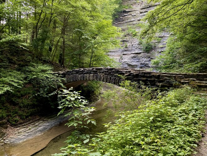
Just about 0.2-miles into the trail sits a scenic stone footbridge that spans Stony Brook. This is just another example of New York's commitment to building scenic pathways through their waterfall-filled gorges. The footbridge simply adds to the beauty of the gorge.
Tranquil Turquoise Pool - Mile 0.25
Around mile 0.25, as the trail beds to the east, hikers will pass a beautiful crystal-clear turquoise pool of water with a short but scenic waterfall that feeds it from above. Here, the trail leads uphill alongside the cascade where you can find a better view into the pool below.
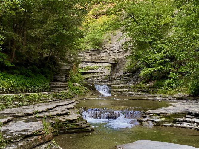
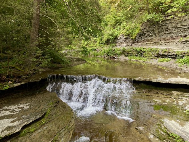
Waterfalls and Wooden Footbridge - Mile 0.3 to 0.33
Around mile 0.3, hikers will reach another scenic view of Stony Brook with small waterfalls that range between 2 and ~5-feet tall cascade down the bedrock. Two waterfalls sit in front of a scenic wooden footbridge that spans the creek. Just beyond the footbridge is the third waterfall that spills down at about ~5 feet tall.
Stony Brook Falls (~35-feet tall) - Mile 0.45
The main attraction along this trail is by-far the largest waterfall in Stony Brook, located around mile 0.45. Stony Brook Falls (nicknamed) is about 35-feet tall with a cascade of water that slopes straight down the steep shale bedrock. Despite the height and volume of water, Stony Brook Falls is relatively quiet, which adds to the tranquility of this hike. The trail leads up and around the southern side of Stony Brook Falls, so hikers can take-in the views from its side profile as you continue up the trail.
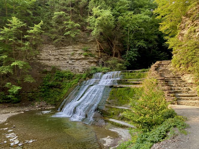
Upper Stony Brook Falls - Mile 0.5
Just around the trail's bend lies the ~20-foot tall Upper Stony Brook Falls waterfall. This cascade is similar to Stony Brook Falls in that the water slopes down the steep bedrock, making for a quiet but scenic cascade. Hikers can take a break if they wish and enjoy the waterfall from near its base or you can continue along the trail to find a scenic view of Upper Stony Brook Falls with a stone staircase that adorns its western side.
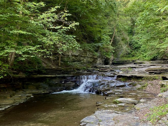
Small Cascades - Mile 0.55 and 0.6
Beyond Upper Stony Brook Falls are a couple of very short cascades within the creek. These are the last of the waterfalls along the hike.
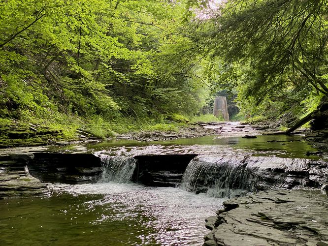
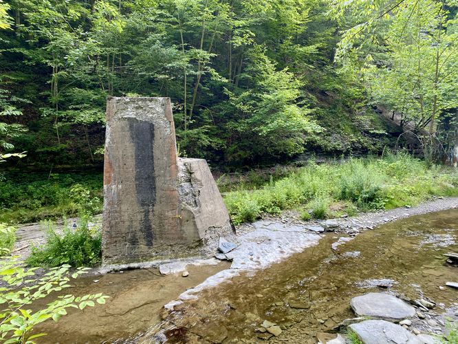
The last sights along the trail are some old concrete pillars that likely were once used for a bridge, maybe for a train that was used to mine resources from the gorge; however, that's speculation. The trail then leads up and out of the gorge following a steep and very-long staircase, hence the moderate difficulty of this hike. The Gorge Trail then ends where hikers can head back toward the parking lot via the West Rim Trail as one option to make a loop hike in the park.
Parking & Fees
As of July 2024, there's a $9/vehicle entrance fee. Hikers will find a large parking lot at the coordinates provided, located at the end of the northern entrance of the park. The lot is large enough to fit several dozen vehicles as of July 2024.
Pets
Dogs are allowed only if leashed and must be cleaned up after.
Restrooms
There are restroom facilities located at the trailhead / parking lot.
Warning
Falling rock: This trail passes through a gorge with loose rock that can randomly fall from high above. This happens randomly and without warning. Hike at your own risk.
Trails
This hike follows one named trail: Gorge Trail (blue blazes).
Swimming Prohibited
Swimming (along other activities) is strictly prohibitted on this trail. Despite the beautiful pools of water, none of them are permitted for swimming. If you're looking to swim, you can do so when a lifeguard is present at the swimming area located at Lower Stony Brook Falls (behind the restrooms)
Hike
This hike begins at the main trailhead area at the park, located on the east side of the large parking lot. As of July 2024, hikers will pass the (newly-built) restroom facility to find the Gorge Trail trailhead located just behind, located along the paved entrance path. If you wish, you can explore Lower Stony Brook Falls before venturing into the gorge for a short out-and-back walk. The gorge trail begins mostly-flat as it leads into the steep and (loose) rock gorge, passing the swimming area first. The trail then bends around a corner to find a small ~5-foot tall waterfall that spills down the bedrock of Stony Brook with a stone staircase that adorns the trail.
Stonework Footbridge - Mile 0.2
Just about 0.2-miles into the trail sits a scenic stone footbridge that spans Stony Brook. This is just another example of New York's commitment to building scenic pathways through their waterfall-filled gorges. The footbridge simply adds to the beauty of the gorge.
Tranquil Turquoise Pool - Mile 0.25
Around mile 0.25, as the trail beds to the east, hikers will pass a beautiful crystal-clear turquoise pool of water with a short but scenic waterfall that feeds it from above. Here, the trail leads uphill alongside the cascade where you can find a better view into the pool below.
Waterfalls and Wooden Footbridge - Mile 0.3 to 0.33
Around mile 0.3, hikers will reach another scenic view of Stony Brook with small waterfalls that range between 2 and ~5-feet tall cascade down the bedrock. Two waterfalls sit in front of a scenic wooden footbridge that spans the creek. Just beyond the footbridge is the third waterfall that spills down at about ~5 feet tall.
Stony Brook Falls (~35-feet tall) - Mile 0.45
The main attraction along this trail is by-far the largest waterfall in Stony Brook, located around mile 0.45. Stony Brook Falls (nicknamed) is about 35-feet tall with a cascade of water that slopes straight down the steep shale bedrock. Despite the height and volume of water, Stony Brook Falls is relatively quiet, which adds to the tranquility of this hike. The trail leads up and around the southern side of Stony Brook Falls, so hikers can take-in the views from its side profile as you continue up the trail.
Upper Stony Brook Falls - Mile 0.5
Just around the trail's bend lies the ~20-foot tall Upper Stony Brook Falls waterfall. This cascade is similar to Stony Brook Falls in that the water slopes down the steep bedrock, making for a quiet but scenic cascade. Hikers can take a break if they wish and enjoy the waterfall from near its base or you can continue along the trail to find a scenic view of Upper Stony Brook Falls with a stone staircase that adorns its western side.
Small Cascades - Mile 0.55 and 0.6
Beyond Upper Stony Brook Falls are a couple of very short cascades within the creek. These are the last of the waterfalls along the hike.
The last sights along the trail are some old concrete pillars that likely were once used for a bridge, maybe for a train that was used to mine resources from the gorge; however, that's speculation. The trail then leads up and out of the gorge following a steep and very-long staircase, hence the moderate difficulty of this hike. The Gorge Trail then ends where hikers can head back toward the parking lot via the West Rim Trail as one option to make a loop hike in the park.
Parking & Fees
As of July 2024, there's a $9/vehicle entrance fee. Hikers will find a large parking lot at the coordinates provided, located at the end of the northern entrance of the park. The lot is large enough to fit several dozen vehicles as of July 2024.
Pets
Dogs are allowed only if leashed and must be cleaned up after.
Restrooms
There are restroom facilities located at the trailhead / parking lot.
Warning
Falling rock: This trail passes through a gorge with loose rock that can randomly fall from high above. This happens randomly and without warning. Hike at your own risk.