Loading...

WINTER SALE! 50% OFF Supporter Accounts — now through January 31st. Learn More.

Goodnough Dike Loop Trail

The Goodnough Dike Loop Trail at Quabbin Reservoir in Ware, Massachusetts is an easy 1.8 mile trail that runs atop the Goodnough Dike and back to parking.

The trail, which is technically a service road, starts off at the gate to Goodnough Dike and quickly hits a fork in the trail. Stay left to get views of Quabbin Reservoir, but if you stay right at the fork, you'll first hike downhill behind the dike.

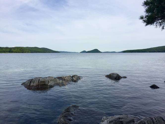
By staying left at the fork, you'll pass the Nature Walk Trail at Quabbin just after the first turn. As you reach the first major turn in the trail, which lies closer to the water, you'll find a picnic table with a small series of trails that heads down to the water. You can find a nice spot to sit by the water by exploring these little trails.

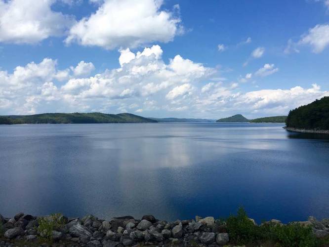
Continuing on, the trail will eventually run atop the dike and you'll get views of the reservoir. At the far end of this loop lies the Gate 50 Trail - The Wall, which is a longer hike down Gate 50 and out to a cliff-edge nicknamed "The Wall". After reaching the far end of the dike, the trail will head downhill and it'll run behind the dike before climbing uphill and back to parking.

This is one of the more popular hikes at Quabbin, but due to the 2 mile length (either loop or out-and-back), it makes it slightly less popular than the Winsor Dam trail.

Parking
Parking can be found at the dirt lot adjacent to the Goodnough Dike gate entrance.

Pets
Dogs are not allowed on any trails at Quabbin.
Explore 207 trails near Ware, MA

Know Before You Go

  • The Goodnough Dike Loop Trail is an easy 1.8-mile hike in Ware, MA, offering views of Quabbin Reservoir.
  • The trail offers options for exploring, including a detour to the water and a connection to the longer Gate 50 Trail ("The Wall").
  • Dogs are prohibited on all Quabbin trails.
Interactive topographic map for Goodnough Dike Loop Trail located in Ware, MA. Click the "View Map" button to load GPS coordinates and trail markers.
Get directions
Distance
1.8 mi
Difficulty
Easy
Type
Loop
Est. Time
54 min
Elev. Gain
164'
Rating
0.0
Added
June 17, 2018
Updated
April 27, 2020

Weather Forecast

Tonight
Low 27°F
Mostly Cloudy
Sunday
High 34°F
Light Snow Likely
Sunday Night
Low 20°F
Snow Likely
M.L. King Jr. Day
High 29°F
Mostly Sunny
Monday Night
Low 13°F
Partly Cloudy
Tuesday
High 20°F
Mostly Sunny
Tuesday Night
Low 6°F
Mostly Clear
Wednesday
High 28°F
Mostly Sunny
Wednesday Night
Low 21°F
Mostly Cloudy
Thursday
High 33°F
Slight Chance Light Snow
Thursday Night
Low 12°F
Slight Chance Light Snow then Partly Cloudy
Friday
High 25°F
Mostly Sunny
Friday Night
Low 15°F
Mostly Cloudy then Slight Chance Light Snow
Saturday
High 26°F
Slight Chance Light Snow
Loading...
Total Change
153'
Ascent
164'
Descent
165'
Loading...

Download the GPX Data for Offline Use

Supporters get exclusive access to download trail routes to the MyHikes app for offline use. Stay prepared on your adventure, even without an internet connection! Become a Supporter today to unlock this feature and hike with confidence.

Download Goodnough Dike Loop Trail GPX Data to the MyHikes Mobile App

Features

Vista / Lookout Point
Biking

Points of interest

  1. Parking

    42.293647, -72.308876
  2. Main Trailhead

    42.294018, -72.308105

Safety information

For your own safety: plan ahead, let someone know where you'll be, and hike at your own risk.

Availability

All seasons

Surface type

Dirt

Trip Reports (Reviews)

Your opinion matters! Be the first to rate this trail.

Ready to help fellow hikers? Add a trip report to share your experience and provide valuable insights for other hikers!

0.8 miles / 1.3 km
June 09, 2018
Hiking
No community routes found. To add your own hike as a Community Route for this Trail guide, leave a Trip Report with an attached GPX file.

Popular categories

Scenic mountain view representing vista trails
Vista trails
Scenic gorge of cascades representing waterfall trails
Waterfall hikes
Rugged mountain terrain representing summit trails
Summit trails
Scenic mountain view representing dog-friendly trails
Dog-friendly
Scenic campsite with a view representing camping trails
Camping trails
Appalachian Trail logo representing A.T. hikes
A.T. hikes

You May Also Like

Colorado's Million Dollar Highway - Plan a day's drive adventure along the iconic Million Dollar Highway in Colorado. Explore the best short trails, roadside stops, waterfalls, vistas, ghost towns, and hot springs within a ~6 hour road trip.
Explore

Colorado's Million Dollar Highway

Plan a day's drive adventure along the iconic Million Dollar Highway in Colorado. Explore the best short trails, roadside stops, waterfalls, vistas, ghost towns, and hot springs within a ~6 hour road trip.

Read
Glacier's Going-to-the-Sun Road - Discover the breathtaking beauty of Glacier National Park along the iconic Going-to-the-Sun Road. From stunning roadside stops to picturesque waterfalls and vistas, this engineering marvel offers endless opportunities for exploration.
Explore

Glacier's Going-to-the-Sun Road

Discover the breathtaking beauty of Glacier National Park along the iconic Going-to-the-Sun Road. From stunning roadside stops to picturesque waterfalls and vistas, this engineering marvel offers endless opportunities for exploration.

Read
🍪 We use cookies to learn about site usage and to serve map tiles. You may block cookies manually in the browser. By continuing you agree. Learn more