The Grinnell Glacier Trail at Glacier National Park near Babb, Montana is a difficult 12-mile out-and-back hike that features breathtaking views of turquoise-colored glacial lakes and leads to one of the most-accessible glaciers in the park, Grinnell Glacier.
Cliffs: This hike passes several cliffs with sheer drops. Watch your step.
Trails
This hike technically follows several named trails in order to reach Grinnell Glacier. Hikers will first follow the Swiftcurrent Lake Trail, North Shore Josephine Lake Trail, and finally the Grinnell Glacier Trail before heading back following the identical but opposite route.Hiking to Grinnell Glacier
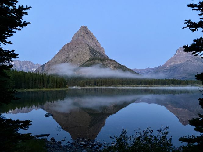
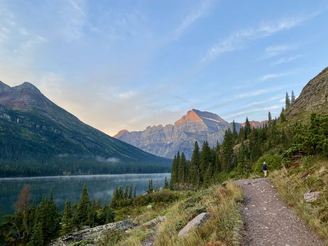
This hike begins at the Many Glacier Hotel parking lot. Hikers will find their way from parking to reach the Swiftcurrent Lake Trail trailhead, located on the south side of the hotel. Here, you'll follow the paved and mostly-flat Swiftcurrent Lake Trail as it loops around Swiftcurrent Lake. Along the way are a multitude of lookout points where hikers will find views of Swiftcurrent Lake, Grinnell Mountain, Altyn Peak, and more. During the early morning, you can find the sunrise on Swiftcurrent Lake to be unmatched to other places in the park, so starting early can provide hikers with even more stunning views.North Shore Josephine Lake Trail - Mile 0.95 to 2
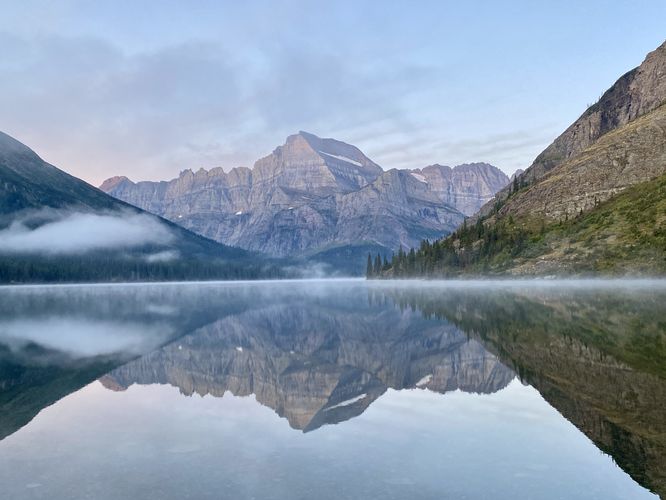
Around mile 0.95, hikers will reach a junction with the North Shore Josephine Lake Trail where it meets up with the loop along the Swiftcurrent Lake Trail. Here, take a left-hand turn to follow this trail as it leads along the north shore of Lake Josephine. At mile 1.1, hikers will find a small path that leads down to the shore of Lake Josephine where you'll find a boat dock and breathtaking views of Mount Gould with its towering ramparts reflecting in the lake's water. Here, you'll find unmatched views of Mount Gould as Lake Josephine's pristine water not only reflects the mountain, but also is clear enough to view the colorful rocks that sit at the bottom of the lake. After passing the boat dock, the North Shore Josephine Lake Trail runs above the water but just below a cliff line. Along this section of trail is a great place to look for longhorn sheep or mountain goats.Grinnell Glacier Trail to Upper Grinnell Lake - Mile 2 to 5.3
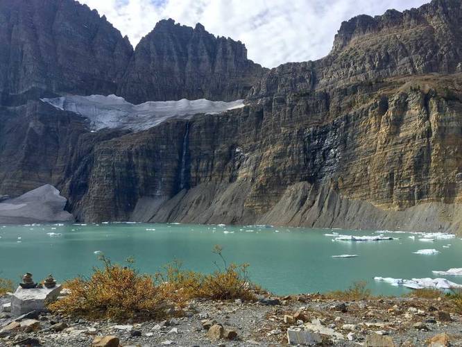
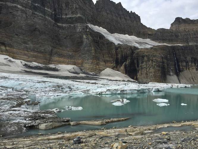
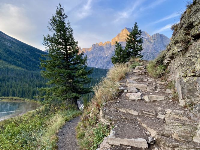
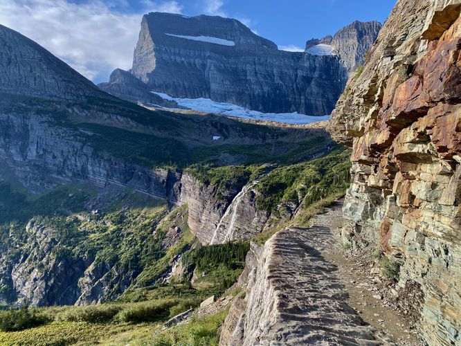
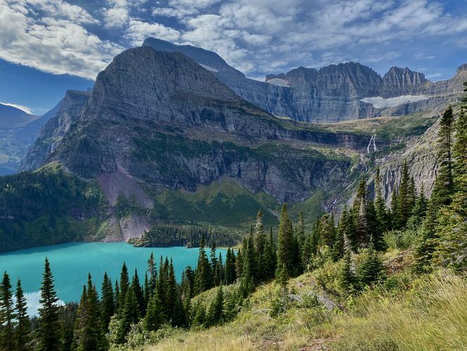
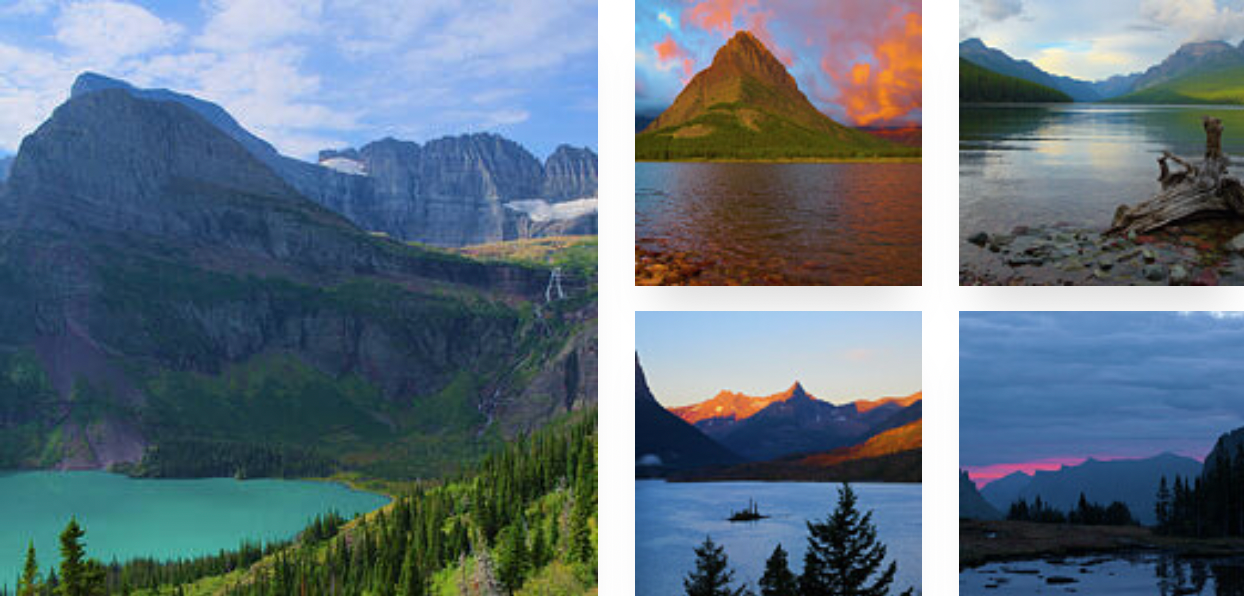
Hikers will reach a junction in the trail, located around mile 2 from the trailhead -- this split in the trail is the official start for the Grinnell Glacier Trail. Keep-right at this fork to continue on toward the glacier. If you miss this turn, do not worry -- you can backtrack 200-feet at the next junction ahead which leads to the same place. Along this stretch of trail, it continues to provide views of Lake Josephine and Mount Gould before it reaches another right-hand turn at mile 2.3. At mile 2.3, keep-right to continue up the trail toward Grinnell Glacier. The hike up from Lake Josephine to Grinnell Glacier (or Upper Grinnell Lake) is not easy, hence the hard difficulty rating, but the trail provides an almost-unlimited amount of views as you hike your way up the valley. Hikers will find breathtaking views along the way like the turquoise colors of Grinnell Lake as it sits below Angel Wing (peak) and is fed directly by Grinnell Glacier via Grinnell Falls. Views also include Salamander and Gem glaciers sitting in the hanging valleys above, Grinnell Falls with its multitude of tiers and 960-feet of plummeting glacial water, along with vast views of the valley below. During our hike here in Sept 2024, in the early morning we heard an elk bugling in the valley below. During my hike here in Sept 2015, we found mountain goat located just off-trail. This section of trail is also known to frequent grizzly bear as well, so keep an eye out and show-up prepared with bear spray just in case. The trail ascends at a moderate grade, following a couple switchbacks, and traverses above several cliffs as it makes its way up to Grinnell Glacier. The hardest section of the trail sits between miles 4.8 to 5.3 where the trail ascends a steep hill located just below Upper Grinnell Lake. This section of trail follows a very steep grade up tall rock steps, so take your time on your way up.Upper Grinnell Lake to Grinnell Glacier - Mile 5.3 to 6
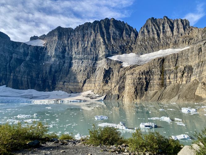
Finally, at mile 5.3, hikers will reach the top of the hill as the trail leads through low-growing shrubs out to a view of Upper Grinnell Lake and the Grinnell Glacier. Here, you can choose to take-in the views of Grinnell Glacier to the left, Salamander Glacier high above, and Gem Glacier sitting above Grinnell. From the hill, you'll have spectacular views of Upper Grinnell Lake with chunks of Grinnell Glacier's ice floating in the water below. This trail guide leads hikers all the way to the very edge of Grinnell Glacier, which is totally optional. This track follows a loosely-defined path as it traverses the bedrock between Grinnell Glacier and the valley below. After crossing an outflow creek from Upper Grinnell Lake, hikers will reach the very edge of Grinnell Glacier around mile 6. Note that most hikers don't venture out to the glacier itself but rather sit far back to enjoy the view. To each their own, but this glacier will disappear sometime in the future. During my hike here in September 2015, we hopped on Grinnell Glacier as it felt like a once-in-a-lifetime opportunity. During my 2nd hike here in September 2024, my wife and I decided to stop halfway between the glacier and the hill instead. Some hikers even swim in Upper Grinnell Lake' freezing waters.Hiking from Grinnell Glacier to Parking - Mile 6 to 12
The hike back to parking is simple -- just follow the same route back as you did up to the glacier; however, there are some nuances to consider. If you begin your hike in the early morning, expect to pass a lot of hikers on your way down as many hikers will be heading up to the glacier. This part of the hike is not very enjoyable as you have to find placed to stop and wait for other hikers on the trail. During my hike here on Sept 30 2015, we saw ~20 other hikers, but during my hike here on Sept 16. 2024 we saw hundreds of hikers on our way down making their way up. Stopping and moving over for hundreds of hikers gets old after many miles of hiking. On your way down, however, don't forget to snap photos of the scenery as it'll be your last chance to do so. Once you reach Lake Josephine you can choose to follow this track back as an out-and-back (most-scenic route) or you can loop around Lake Josephine for a different perspective. The adventure ends at the Many Glacier Hotel for a ~12-mile out-and-back day hike.Vehicle Reservations
Depending on what time of year you visit, you may need to reserve a vehicle entrance pass to get into the park, in addition to a park entry fee (or annual National Parks pass). Before planning this hike, ensure you've checked the NPS website for when and where Glacier NP vehicle reservations are required.Parking at Many Glacier Hotel
This trail guide leads hikers to the parking lot at Many Glacier Hotel to start their hike, which is located at the coordinates provided. The parking lot is large enough to fit many dozens of vehicles as of September 2024. Note that if you plan to park here when the hotel is open for the season, the parking lot may be mostly-full from the visitors who are staying at the hotel.Parking Construction (Sept 2024 - May 2026)
Additional parking note: The park began construction west of the Many Glacier Hotel access road on September 16, 2024. This closed down the road and the western parking lot for the Swiftcurrent Lake Loop Trail / Grinnell Glacier Trail trailheads, forcing hikers to use the Many Glacier Hotel parking lot until the road reopens in May 2026. For the time being, this parking lot and trailhead will be the main access to Grinnell Glacier until construction is completed. Due to this, parking is even-more limited for this hike. If you show-up before the Many Glacier Hotel closes for the season, you'll have to battle for parking spaces or show-up super early in the morning to claim a spot. We woke up at 4AM to do the 2.5-hour drive from West Glacier to snag a spot around 6:30AM to start our hike -- at the time, the hotel was closing the same day so hotel guests had filled 90% of the parking lot, leaving very-little room for day hikers traveling from other places. For more details, please see the official page for the Swiftcurrent area construction.Pets
Dogs are not allowed on any trails at Glacier National Park.Wildlife
This trail is great for possible wildlife viewing opportunities including mountain goats and longhorn sheep high in the cliffs or near trail grazing, moose, elk, deer, and even grizzly bears on occasion.Warning
Grizzly bears: This trail is frequented often by grizzly bears, especially in late Summer and early Fall as they scrounge for 20 hours/day bulking for the winter. Always give wild animals plenty of space, including several hundred feet for grizzlies. It's best to bring bear spray on this hike as a last defense just in case a grizzly were to charge at you. Always make plenty of noise while hiking to alert animals to your presence long before you see them. It's also smart to hike with another person.Cliffs: This hike passes several cliffs with sheer drops. Watch your step.