Loading...

🎉 Enjoy a Free 7-Day Supporter Trial and Unlock Exclusive Perks — No Credit Card Required. Learn more.

Gerhard Shelter Hike

Directions
Map
Pictures
Send to App
Distance:
9.9 Miles / 15.9 km
Type:
Loop
Difficulty:
Hard
Time to Hike:
4 hours, ~57 minutes
Features:
Surface Type:
Dirt
Park:
George Washington National Forest
Town:
Wardensville, West Virginia
Directions:
39.015287, -78.604946
Added:
January 25, 2025
Updated:
April 04, 2025
Copy Trail Link Hiking this trail? Send a friend or family member a link to this trail guide for your own safety. Hike at your own risk (disclaimer)
Loading...
Loading...
1,273'

Total Change
1,547'

Ascent
1,526'

Descent

Download the Trail Route for Offline Use

Supporters get exclusive access to download trail routes to the MyHikes app for offline use. Stay prepared on your adventure, even without an internet connection! Become a Supporter today to unlock this feature and hike with confidence.

Send to App

Gerhard Shelter Hike

There are some nice views on both sides of Great North Mountain from the ridge just before arriving at Gerhard Shelter. The views of the valley from Vance's Cove can be wonderful on a clear day as well, but the main attraction is the solitude. We have never seen other hikers on this route.

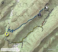
Begin by turning left uphill on the blue blazed Tuscarora Trail passing a closed gate. At this point the trail is a closed forestry road (FS) that slowly climbs the side of the mountain for 0.8 miles before the blue blazed Tuscarora Trail makes a sharp right, and the FS road continues straight. Turn right on the blue blazed trail. If you start going downward on the FS road you missed the right turn.

The blue blazed trail climbs the side of Great North Mountain steeply and makes several switchbacks before reaching the ridge line in another 3.0 miles. Follow the ridge for 1.0 miles and arrive at Gerhard Shelter. The shelter is generally used by through hikers.

Turn right downhill on the white blazed Gerhard Shelter Trail that very steeply descends Great North Mountain. The footing is precarious with loose stone for the majority of the descent. In 0.5 miles pass a side trail on the left that takes you to a spring, and in another 0.2 miles emerge onto a FS road.

Turn right on the unblazed forestry road. The forestry road is normally closed to motorized traffic, unless your hiking during hunting season (bad idea!). At the end of the FS road in 0.8 miles, just past a burn, the unmarked Vance's Cove connector trail will bear right. Follow the trail for 0.5 miles where it merges with the yellow blazed Vance's Cove Trail.

Stay right on the now yellow blazed trail for another 0.2 miles where the Vance's Cove Trail ends and a sign marking the border of WV and VA. Turn right on the yellow blazed Wilson Cove Trail and FS road as it winds through the valley for 2.0 miles and passes a closed gate and small parking area. Continue down to Waites Run FS Road passing a private driveway on your left at the bottom of the hill. Continue to your right on Waites Run FS Road road for another 0.8 miles back to the parking area.

Explore 67 trails near Wardensville, WV
  1. Parking

    39.015287, -78.604946
  2. Main Trailhead

    39.01505, -78.60492
No community routes found. To add your own hike as a Community Route for this Trail guide, leave a Trip Report with an attached GPX file.

Hazards

Ticks - Lyme Disease More Info (CDC)
Snakes
Poison Ivy/Oak

Seasons

All

Trip Reports

Trail Guide By:
HikingUpward user profile picture
9.9 miles / 15.9 km

Weather Forecast

In Wardensville, WV

Explore Hiking Trails

You May Also Like

Colorado's Million Dollar Highway - Plan a day's drive adventure along the iconic Million Dollar Highway in Colorado. Explore the best short trails, roadside stops, waterfalls, vistas, ghost towns, and hot springs within a ~6 hour road trip.
Explore

Colorado's Million Dollar Highway

Plan a day's drive adventure along the iconic Million Dollar Highway in Colorado. Explore the best short trails, roadside stops, waterfalls, vistas, ghost towns, and hot springs within a ~6 hour road trip.

Read
New York's Best Waterfalls - Whether you're planning a day hike, roadside stop, or a leisurely short walk, this guide provides hikers, travelers, and locals alike with 63 different locations to over 100 scenic waterfalls to help plan your next adventure!
Explore

New York's Best Waterfalls

Whether you're planning a day hike, roadside stop, or a leisurely short walk, this guide provides hikers, travelers, and locals alike with 63 different locations to over 100 scenic waterfalls to help plan your next adventure!

Read

Before you boogie...

Find our trail guides useful? Consider becoming a Supporter to unlock perks!

MyHikes is an indie platform that makes exploring public trails easier for everyone. The platform has no investors, no ads, and is owned and operated by one person, Dave Miller. Dave has personally mapped and written over 1,800 trail guides on MyHikes for the public to explore. MyHikes has helped millions outdoor enthusiasts plan their next adventure.

But it takes a lot of time 🕦, money 💰, work, and espresso shots ☕ to run MyHikes, including hiking , mapping , writing , and publishing new trails with high-quality (accurate) information... along with software engineering (coding) the platform like building new features, website and mobile app development (iOS and Android), site maintainance . and much much more.

Supporters unlock website and mobile app perks with an annual one-time payment of $25 (you renew) 😎👍. Or you can simply make a Donation of your choice. Otherwise, you can support us by telling your friends about MyHikes - both quick and free 🎉

Admin user profile picture

Dave Miller
MyHikes Founder