Loading...

🎉 Enjoy a Free 7-Day Supporter Trial and Unlock Exclusive Perks — No Credit Card Required. Learn more.

G. R. Thompson Wildlife Management Area Hike

Directions
Map
Pictures
Send to App
Distance:
8.6 Miles / 13.8 km
Type:
Loop
Difficulty:
Moderate
Time to Hike:
4 hours, ~18 minutes
Features:
Appalachian Trail hike
Surface Type:
Dirt
Town:
Paris, Virginia
Directions:
38.957405, -77.988988
Added:
April 03, 2025
Updated:
April 06, 2025
Copy Trail Link Hiking this trail? Send a friend or family member a link to this trail guide for your own safety. Hike at your own risk (disclaimer)
Loading...
Loading...
1,190'

Total Change
1,692'

Ascent
1,692'

Descent

Download the Trail Route for Offline Use

Supporters get exclusive access to download trail routes to the MyHikes app for offline use. Stay prepared on your adventure, even without an internet connection! Become a Supporter today to unlock this feature and hike with confidence.

Send to App

G. R. Thompson Wildlife Management Area Hike

This hike loops around the entire G. Richard Thompson Wildlife Management Area and is one of our favorites in the winter months. Almost 8 miles in length and with an elevation remaining under 2,200 feet, you can still have a great hike when the daylight hours are shorter.


IMPORTANT NOTE: This hike is in a Virginia Wildlife Management Area which now requires a permit.
Effective January 1, 2012, The Virginia Department of Game and Inland Fisheries (DGIF) requires an Access Permit for visitors to department-owned Wildlife Management Areas (WMAs) and public fishing lakes for anyone age 17 and older, unless they possess a valid Virginia hunting, freshwater fishing, or trapping license, or a current Virginia boat registration. All hikers who are age 17 and older, unless they possess a valid Virginia hunting, freshwater fishing, or trapping license, or a current Virginia boat registration, will need an access permit to hike on any Wildlife Management Area.

The one thing to keep in mind is that this area is very popular during hunting season, so make sure you wear some blaze orange if you are hiking anytime from late November to the end of January.

If you do this hike in nice weather a great way to top this hike off is to stop for lunch at Maxwell's Pub in Middleburg on the way back and grab a seat on their outdoor deck, which is dog friendly.

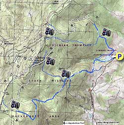
Start by walking up the dirt road to Lake Thompson. Turn right walking beside the lake and then veer right uphill. You will run into several large blow downs from tropical storm Camille obstructing the trails.

After .8 miles come to the intersection of Lake Trail that turns to the left. Continue straight on the smaller Stone Wall Trail for the steepest portion of the hike. In .5 miles the Appalachian Trail (AT) will enter from your right.

Continue straight (which now becomes the AT) for 1.2 mile where the trail branches, stay left on the white blazed AT until crossing the Lake Trail in another .3 miles.

In another .6 miles the AT will cross a dirt road. Rejoin the white blazed AT on the opposite side of the dirt road. In .3 miles pass a side trail on your right. Start descending and in 1.1 miles you will reach the junction of the Vernon Smith Trail (VST).

Turn left on the VST (the AT is part of this) and in 70 yards the AT will turn to your right. Continue straight on the VST for 1.2 miles as it winds around Wildcat Hollow before passing some ruins and a small trail on your left. Continue straight on the VST for another .7 miles where it reaches a small shed and intersects a dirt road.

Turn right on the dirt road for .1 miles until the road branches, veer left as you continue downhill for another .9 miles. This section of the trail runs alongside a fence and private property as it descends the mountain.

A trail will intersect from the left (private property with a red barn on your right). Turn left downhill for 100 yards. Then turn right at the four way trail junction. In 150 yards, you will arrive back at Thompson Lake. Continue straight back to the parking lot.

Explore 60 trails near Paris, VA
  1. Parking

    38.957405, -77.988988
  2. Main Trailhead

    38.957306, -77.98851
No community routes found. To add your own hike as a Community Route for this Trail guide, leave a Trip Report with an attached GPX file.

Hazards

Ticks - Lyme Disease More Info (CDC)
Snakes
Poison Ivy/Oak

Seasons

All

Trip Reports

Trail Guide By:
HikingUpward user profile picture
8.6 miles / 13.8 km

Weather Forecast

In Paris, VA

Explore Hiking Trails

You May Also Like

New York's Best Waterfalls - Whether you're planning a day hike, roadside stop, or a leisurely short walk, this guide provides hikers, travelers, and locals alike with 63 different locations to over 100 scenic waterfalls to help plan your next adventure!
Explore

New York's Best Waterfalls

Whether you're planning a day hike, roadside stop, or a leisurely short walk, this guide provides hikers, travelers, and locals alike with 63 different locations to over 100 scenic waterfalls to help plan your next adventure!

Read
25 Best Day Hikes in North Carolina - Discover the top 25 best day hikes in North Carolina, from breathtaking waterfalls to mountain peaks. Explore hidden gems, scenic views, and trails suitable for all skill levels, perfect for your next outdoor adventure.
Explore

25 Best Day Hikes in North Carolina

Discover the top 25 best day hikes in North Carolina, from breathtaking waterfalls to mountain peaks. Explore hidden gems, scenic views, and trails suitable for all skill levels, perfect for your next outdoor adventure.

Read

Before you boogie...

Find our trail guides useful? Consider becoming a Supporter to unlock perks!

MyHikes is an indie platform that makes exploring public trails easier for everyone. The platform has no investors, no ads, and is owned and operated by one person, Dave Miller. Dave has personally mapped and written over 1,800 trail guides on MyHikes for the public to explore. MyHikes has helped millions outdoor enthusiasts plan their next adventure.

But it takes a lot of time 🕦, money 💰, work, and espresso shots ☕ to run MyHikes, including hiking , mapping , writing , and publishing new trails with high-quality (accurate) information... along with software engineering (coding) the platform like building new features, website and mobile app development (iOS and Android), site maintainance . and much much more.

Supporters unlock website and mobile app perks with an annual one-time payment of $25 (you renew) 😎👍. Or you can simply make a Donation of your choice. Otherwise, you can support us by telling your friends about MyHikes - both quick and free 🎉

Admin user profile picture

Dave Miller
MyHikes Founder