We initially did this hike on a very cold day early in January, there were no other hikers that day and I am willing to bet most hikes on this property will be ones of almost complete solitude. You will be rewarded with some great views and on the back half of the hike you will see The Priest, Three Ridges and Wintergreen Resort.
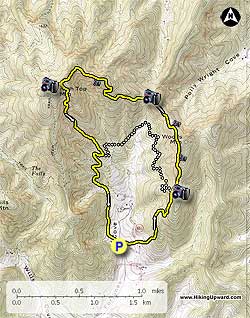
The hike begins at the entrance to the parking lot, bear left onto the gravel road heading uphill and in a short distance the trail will leave the road to right onto the trail marked with 2 blue poles. Many of the trees will be marked with information tags about the trees and also yellow and green arrow metal tags for direction. The trail quickly begins a tough 1400' climb, with a few short reprieves. The trail is basically a ridge hike around the Fortune's Cove Valley
- Mile 0.8 – you will reach the first of 6 views and in another 01. miles the intersection to the lower loop trail.
- Mile 1.1 – 2nd View
- Mile 1.7 – 3rd View
- Mile 2.7 – 4th View
- Mile 3.0 – 5th View, you should be able to catch a glimpse of The Priest, Three Ridges and Wintergreen Resort.
- Mile 3.1 – Short Spur Trail to Hightop. Large Cell Tower on top, but nice views if leaves are off the trees.
- Mile 3.6 – 6th and last view.
- Mile 4.2 – Intersection of the Lower Loop Trail.
The last part of the trail from High Top Mountain is downhill the rest of the way, and will pass a nice creek on the way back to the parking lot. The trail will end up on the gravel road and you will turn left to reach the parking lot in a short distance.