Flume Falls at Adirondack Park within the Wilmington Wild Forest in Wilmington, New York is a moderate 0.3-mile out-and-back hike that runs along a steep gorge with views of several flume waterfalls below.
Hike Description
Note that this hike is not for the average hiker as this trail is not really an official trail but rather a bushwhack that leads through the woods along a dangerous gorge. Hikers who are interested in viewing these waterfalls should also do so at their own risk. For hikers willing to take that risk, read on.
The "trailhead" can be found directly across the street from the parking lot for the River Trail & Flume Falls, which technically includes the upper-portion of Flume Falls. Hikers will hop over the road's guardrail to immediately head down a very steep hill.
The Flume Waterfall - Mile 0.02
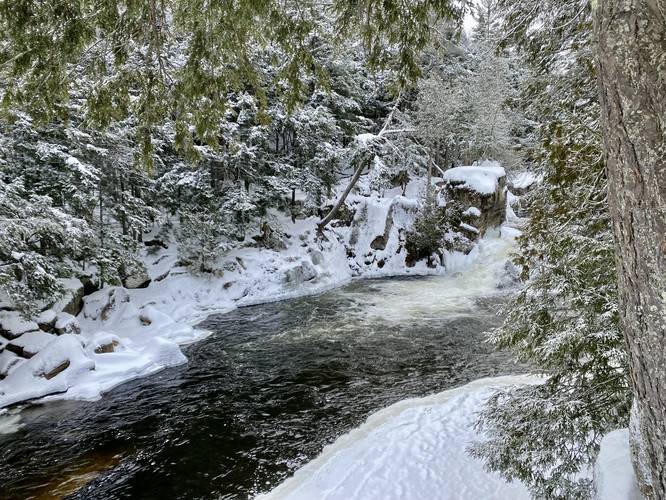
Right where the steep hill levels out, adjacent to the gorge/flume, is where hikers will spot one of the first Flume Waterfalls in the gorge below, known as The Flume Falls, as it sits within the gorge and spills down a narrow flume in the rocks. Hikers must be careful here as the best view is very close to the edge of the gorge.
After passing the first waterfall viewing area, hikers will want to head northeast and then due-north - down a series of rocks - to reach the forest floor. Hike around the rocky outcropping and then back onto it not too far east from where you came downhill from the rocks. You'll find another rocky outcropping and opening within the trees - head there.
Lower Flume Falls - Mile 0.12
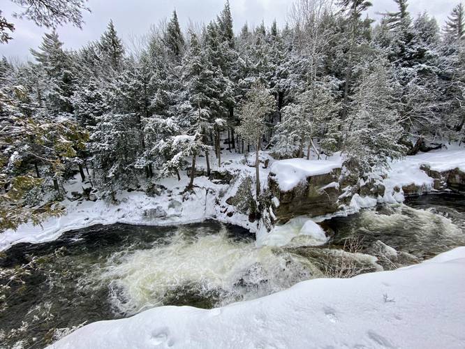
After coming back up to the opening, hikers will find Lower Flume Falls sitting in the gorge below them. This waterfall is less flume-like and more of a regular waterfall that sits about 12-feet tall and 15-feet wide at most (albeit, it might be slightly shorter). The view from the top of the waterfall is the best view you'll get, but it's not the last view to explore here.
Lower Flume Falls Lookout - Mile 0.15
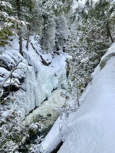
Hike east just a bit further and around the rocky ledge to get two views - one view facing east of the scenic West Branch Ausable River - and the other view facing southwest - of Lower Flume Falls. Here, hikers can get a really nice, but somewhat sketchy view, of Flume Falls. This rock ledge sits about 15-feet above the river, so watch your step, especially during the winter.
Parking
Hikers will find a medium-sized parking lot at the coordinates provided which is the main parking area for the Flume Trail System within Adirondack Park. The lot is large enough to fit about a dozen vehicles, maximum, as of January 2023.
Pets
Dogs are allowed if leashed and their waste should be carried out by the hiker.
Warnings
Steep ledges: Hikers should be aware of the steep and dangerous ledges that sit along the "trail" / bushwhack path here. Any fall into the gorge would likely result in serious injury, if not death. During the winter, it's impossible to see where the snow and gorge edge end, thus, the smart thing to do is to stay away from the ledge. Test every step and use a trekking pole to understand the terrain before committing to stepping there.
Bushwhack: There really is not much of a trail or path here. Navigating this terrain, while very short, should really only be done by experienced hikers and bushwhackers.
Hike Description
Note that this hike is not for the average hiker as this trail is not really an official trail but rather a bushwhack that leads through the woods along a dangerous gorge. Hikers who are interested in viewing these waterfalls should also do so at their own risk. For hikers willing to take that risk, read on.
The "trailhead" can be found directly across the street from the parking lot for the River Trail & Flume Falls, which technically includes the upper-portion of Flume Falls. Hikers will hop over the road's guardrail to immediately head down a very steep hill.
The Flume Waterfall - Mile 0.02
Right where the steep hill levels out, adjacent to the gorge/flume, is where hikers will spot one of the first Flume Waterfalls in the gorge below, known as The Flume Falls, as it sits within the gorge and spills down a narrow flume in the rocks. Hikers must be careful here as the best view is very close to the edge of the gorge.
After passing the first waterfall viewing area, hikers will want to head northeast and then due-north - down a series of rocks - to reach the forest floor. Hike around the rocky outcropping and then back onto it not too far east from where you came downhill from the rocks. You'll find another rocky outcropping and opening within the trees - head there.
Lower Flume Falls - Mile 0.12
After coming back up to the opening, hikers will find Lower Flume Falls sitting in the gorge below them. This waterfall is less flume-like and more of a regular waterfall that sits about 12-feet tall and 15-feet wide at most (albeit, it might be slightly shorter). The view from the top of the waterfall is the best view you'll get, but it's not the last view to explore here.
Lower Flume Falls Lookout - Mile 0.15
Hike east just a bit further and around the rocky ledge to get two views - one view facing east of the scenic West Branch Ausable River - and the other view facing southwest - of Lower Flume Falls. Here, hikers can get a really nice, but somewhat sketchy view, of Flume Falls. This rock ledge sits about 15-feet above the river, so watch your step, especially during the winter.
Parking
Hikers will find a medium-sized parking lot at the coordinates provided which is the main parking area for the Flume Trail System within Adirondack Park. The lot is large enough to fit about a dozen vehicles, maximum, as of January 2023.
Pets
Dogs are allowed if leashed and their waste should be carried out by the hiker.
Warnings
Steep ledges: Hikers should be aware of the steep and dangerous ledges that sit along the "trail" / bushwhack path here. Any fall into the gorge would likely result in serious injury, if not death. During the winter, it's impossible to see where the snow and gorge edge end, thus, the smart thing to do is to stay away from the ledge. Test every step and use a trekking pole to understand the terrain before committing to stepping there.
Bushwhack: There really is not much of a trail or path here. Navigating this terrain, while very short, should really only be done by experienced hikers and bushwhackers.