Loading...

WINTER SALE! 50% OFF Supporter Accounts — now through January 31st. Learn More.

Five Peaks Loop Hike

Hanging Rock State Park, less than an hour from Greensboro and Winston-Salem, has some of the finest and most accessible hiking in North Carolina. The ancient Sauratown Mountains lie east of the Blue Ridge escarpment and although not high by normal standards, rise more than 1,000 feet above the rolling hills of the Piedmont. Eroded white quartzite cliffs are the defining feature of the park.

This hike will take you on the grand tour of all of the vistas in the state park, including the namesake Hanging Rock and Moore’s Knob, the tallest peak in the Sauratown Mountains at 2,579 feet. You’ll also get outstanding views from Wolf Rock, House Rock, Cook’s Wall, and Hanging Rock Lake on this moderate hike that is easier than the distance suggests.

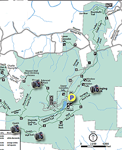
From Danbury follow NC-89 and NC-8 north to Hanging Rock Park Rd. You can park at either the visitor center or the upper parking lot at Hanging Rock Lake. The hike begins at the visitor center and goes clockwise to Hanging Rock first because this section can get quite crowded on weekend afternoons. If you want optimal photographic conditions and like to get the hardest climb out of the way, head counterclockwise to start with Moore’s Knob.  

  • Mile 0.0 – Hike begins at the visitor center parking lot. The Hanging Rock Trail (orange circle blaze) begins on the far left side. The trail is initially paved before transitioning to gravel. This is one of the most popular trails in the park.
  • Mile 0.6 – Junction with the Wolf Rock Trail (blue triangle blaze). Continue left on the Hanging Rock Trail for 0.7-mi to Hanging Rock. The trail climbs under the prominent summit on many stairs. Eventually the trail reaches the ridge and turns left towards the peak.
  • Mile 1.3 – Reach the summit of Hanging Rock, a huge series of rock outcrops jutting out on the west side of the mountain. From here you can see the visitor center far below. Moore’s Knob and Cook’s Wall Mountain are the prominent peaks directly west. You will also have great views north of the Blue Ridge Mountains in Virginia, and the flatlands to the south. On clear days you can see in the south the downtown buildings of Winston-Salem and Greensboro. Along Hanging Rock there are many cliffs to explore. Be careful because a fall would be fatal. Turn around and head back to the junction with the Wolf Rock Trail.
  • Mile 2.1 – Go left on the Wolf Rock Trail (blue triangle blaze). The trail changes to a narrow dirt path and receives much less foot traffic.
  • Mile 2.9 – Reach Wolf Rock, a giant rock outcrop on the south side of the ridge connecting Hanging Rock Mountain and Cook’s Wall Mountain. The primary view is south of the Piedmont and you can also spy House Rock along the Cook’s Wall Trail.
  • Mile 3.2 – The Wolf Rock Trail ends at a junction with the Cook’s Wall Trail at Wolf Gap. Continue straight on the Cook’s Wall Trail (white diamond blaze).
  • Mile 3.6 – Junction with the Magnolia Springs Trail (blue square blaze). Continue straight on the Cook’s Wall Trail for 1 mile to the trail terminus.
  • Mile 3.9 – Reach House Rock which is unlike the other rock outcrops in the park because the outcrop is very flat. The main views are south and also east of Wolf Rock and Hanging Rock. Continue along the Cook’s Wall Trail which gradually ascends the mountain.
  • Mile 4.6 – The trail ends at Devil’s Chimney, a rock outcrop with a view north of Huckleberry Ridge and Moore’s Knob. On the left is a large cliff on Cook’s Wall with your first view to the west of Sauratown Mountain and Pilot Mountain. Turn around to head back to the Magnolia Springs Trail.
  • Mile 5.7 – Turn left on the Magnolia Springs Trail (blue square blaze).
  • Mile 6.0 – Pass a spur trail on the right to Magnolia Springs (no blaze).
  • Mile 6.2 – Cross over East Fork Cascade Creek on 2 small bridges then reach the Moore’s Wall Loop Trail. Turn left on the Moore’s Wall Loop Trail (red circle blaze) heading west on a moderate ascent to Huckleberry Gap.
  • Mile 6.7 – Junction with the Tory’s Den Trail (blue circle blaze) and Mountains-to-Sea Trail (white circle blaze) near Huckleberry Gap. Turn right heading north along the Moore’s Wall Loop Trail/Mountains-to-Sea Trail (red circle and white circle blazes). The trail begins a steep 1.2-mile ascent up Huckleberry Ridge over a minor summit before dropping into a gap and ascending Moore’s Knob. This is the steepest and longest climb of the hike. Once on Huckleberry Ridge you will have views through the trees and pass by multiple large boulders and stands of Catawba rhododendron which bloom mid-May.
  • Mile 7.9 – Reach the spur trails to Balanced Rock and Moore’s Knob observation tower. Moore’s Knob is the tallest peak in the Sauratown Mountains at 2,579 feet and features a huge, exposed cliff on the northwest side. The original fire tower has been refurbished as a lookout tower. Climb the stairs to get 360° views. You can trace most of the hike from east to south with the visitor center, Hanging Rock, Cook’s Wall Mountain and Huckleberry Ridge all clearly visible. Pilot Mountain and the Blue Ridge Mountains dominate the western and northern vistas. Continue following the Moore’s Wall Loop Trail south down the mountain. This section of the trail gets more foot traffic since it is a shorter distance from the parking areas. The descent is mostly on a wide gravel and dirt path with hundreds of steps.
  • Mile 9.0 – Rock crossing over West Fork Cascade Creek.
  • Mile 9.1 – The trail turns right briefly following the campground road before turning left descending steeply to Hanging Rock Lake.
  • Mile 9.4 – In the vicinity of a small crossing over East Fork Cascade Creek is a junction with the Fishing Access Trail (no blaze) on the left and the Chestnut Oak Nature Trail (no blaze) on the right. The trail continues east closely following the southern shore of Hanging Rock Lake.
  • Mile 9.7 – Pass by the boat house at the lake. Take a left on the Mountains-to-Sea Trail (white circle blaze) avoiding the sidewalk to the picnic areas and upper parking lot on the right.
  • Mile 9.8 – Stop at a fishing pier in Hanging Rock Lake with great views of Cook’s Wall and Moore’s Knob rising above the water.
  • Mile 9.9 – The Mountains-to-Sea Trail crosses the road on its way to the visitor center.
  • Mile 10.9 – Hike ends at the visitor center parking lot.
By HikingUpward Contributor: Zach Robbins
Explore 6 trails near Westfield, NC

Know Before You Go

  • The Five Peaks Loop Hike in Hanging Rock State Park offers a challenging but rewarding 10.9-mile trek with panoramic views from multiple peaks, including Hanging Rock and Moore's Knob.
  • The trail provides diverse scenery, including quartzite cliffs, rock outcrops, and lake views, with options to customize the experience by choosing a clockwise or counterclockwise direction based on desired photographic conditions or difficulty preference.
  • The hike passes key landmarks such as Wolf Rock, House Rock, and Cook's Wall, and involves varying terrains, from paved paths to steep ascents, requiring hikers to be prepared for a range of physical challenges.
Interactive topographic map for Five Peaks Loop Hike located in Westfield, NC. Click the "View Map" button to load GPS coordinates and trail markers.
Get directions
Distance
10.9 mi
Difficulty
Hard
Type
Loop
Est. Time
5.5 hrs
Elev. Gain
2,333'
Rating
4.7
Added
March 22, 2025
Updated
April 06, 2025

Weather Forecast

M.L. King Jr. Day
High 40°F
Sunny
Tonight
Low 19°F
Mostly Clear
Tuesday
High 34°F
Sunny
Tuesday Night
Low 20°F
Mostly Clear
Wednesday
High 40°F
Mostly Sunny
Wednesday Night
Low 29°F
Mostly Cloudy then Slight Chance Light Rain
Thursday
High 48°F
Slight Chance Light Rain
Thursday Night
Low 27°F
Partly Cloudy
Friday
High 42°F
Slight Chance Light Rain
Friday Night
Low 26°F
Chance Rain And Snow
Saturday
High 30°F
Chance Rain And Snow
Saturday Night
Low 17°F
Chance Light Snow
Sunday
High 26°F
Chance Light Snow
Sunday Night
Low 16°F
Chance Light Snow
Loading...
Total Change
951'
Ascent
2,333'
Descent
2,332'
Loading...

Download the GPX Data for Offline Use

Supporters get exclusive access to download trail routes to the MyHikes app for offline use. Stay prepared on your adventure, even without an internet connection! Become a Supporter today to unlock this feature and hike with confidence.

Download Five Peaks Loop Hike GPX Data to the MyHikes Mobile App

Features

Vista / Lookout Point
Dogs
Waterfalls
Mountain Summit
Water Source

Points of interest

  1. Parking

    36.394835, -80.265568
  2. Main Trailhead

    36.395016, -80.265276

Safety information

For your own safety: plan ahead, let someone know where you'll be, and hike at your own risk.

Hazards

Snakes (Rattlesnakes, Copperheads, others)
Poison Ivy or Poison Oak

Availability

All seasons

Surface type

Dirt

Trip Reports (Reviews)

Rated 4.71 out of 5 based on 7 ratings.

Ready to help fellow hikers? Add a trip report to share your experience and provide valuable insights for other hikers!

By: Zachary Robbins
10.9 miles / 17.5 km
January 07, 2018
I decided to do a quick 4.5-mile detour in the middle of my frozen waterfall day and hike the Moore's Wall Loop Trail, which is approximately 40% of this full hike. The skies were too blue to pass up some views, despite the brutally cold weather. I took the trail west from Hanging Rock Lake, which follows the Five Peaks Loop listed here after the Magnolia Springs Trail junction. I had to shed my jacket and hat on the climb up Huckleberry Ridge, it is a consistent gradient that will make you work. At 25F I was in a shirt and pullover fleece and feeling fine. When I reached the tower I was the only one there for 30 minutes, while hundreds of people were exploring the waterfalls. The views from the lookout tower were outstanding as always, I think I'll write this up as a alternative, shorter hike to the Five Peaks Loop. Not everyone can do 10 miles. On my way down I took the trail around the lake which adds a little distance but is worth it. Overall I saw less than 20 people on this loop in 3 hours, it is one of the less crowded areas of the park.
Legacy Review
By: Alex
10.9 miles / 17.5 km
October 30, 2016
Did the hike yesterday exactly as described here. Nice sunny day, unusually warm for this time of the year. Leaves aren't getting much of the color this year, but there is still some nice foliage to see along the way. All trails are well marked- you can do the whole hike without looking at the map once. My favorite views on this hike are along the Wolf Rock/Cook's Wall side. One also gets full 360 panorama from Moore's Knob. Trail to Hanging Rock gets very crowded on the weekends- try to hit it first and do it before 9 am if possible.
Legacy Review
By: Jeff Johnson
10.9 miles / 17.5 km
August 30, 2013
On Friday, 8/30/13, We hiked the Moore's Wall trail to Moore's Knob and the viewing tower. It was a wonderful hike. We parked in the Bathhouse parking lot, walked past the Bathhouse and lake on our right, following the trail till it split. We chose to turn left which took us up the less refined trail to Moore's Knob and the tower - excellent views. The remainder of the trail was wide and refined with steps. Along the way we stopped at balancing-rock and other out looks, returning via the camp grounds to the Bathhouse. Due to a staffing shortage, the Bathhouse and lake was closed. Scheduled to open for the three day Labor Day weekend, however. Due to the staffing shortage, there was no one to tell us not to climb over the fence and swim, so we did. We had the lake to ourselves. The water was wonderful. As we left, another hiker was climbing over the fence. During our six hours in the park, we saw maybe eight other people. I can't wait to go back. We'll hike Peaks of Otter 9/14-15/2013.
Legacy Review
No community routes found. To add your own hike as a Community Route for this Trail guide, leave a Trip Report with an attached GPX file.

Popular categories

Scenic mountain view representing vista trails
Vista trails
Scenic gorge of cascades representing waterfall trails
Waterfall hikes
Rugged mountain terrain representing summit trails
Summit trails
Scenic mountain view representing dog-friendly trails
Dog-friendly
Scenic campsite with a view representing camping trails
Camping trails
Appalachian Trail logo representing A.T. hikes
A.T. hikes

You May Also Like

25 Best Day Hikes in North Carolina - Discover the top 25 best day hikes in North Carolina, from breathtaking waterfalls to mountain peaks. Explore hidden gems, scenic views, and trails suitable for all skill levels, perfect for your next outdoor adventure.
Explore

25 Best Day Hikes in North Carolina

Discover the top 25 best day hikes in North Carolina, from breathtaking waterfalls to mountain peaks. Explore hidden gems, scenic views, and trails suitable for all skill levels, perfect for your next outdoor adventure.

Read
Colorado's Million Dollar Highway - Plan a day's drive adventure along the iconic Million Dollar Highway in Colorado. Explore the best short trails, roadside stops, waterfalls, vistas, ghost towns, and hot springs within a ~6 hour road trip.
Explore

Colorado's Million Dollar Highway

Plan a day's drive adventure along the iconic Million Dollar Highway in Colorado. Explore the best short trails, roadside stops, waterfalls, vistas, ghost towns, and hot springs within a ~6 hour road trip.

Read
Glacier's Going-to-the-Sun Road - Discover the breathtaking beauty of Glacier National Park along the iconic Going-to-the-Sun Road. From stunning roadside stops to picturesque waterfalls and vistas, this engineering marvel offers endless opportunities for exploration.
Explore

Glacier's Going-to-the-Sun Road

Discover the breathtaking beauty of Glacier National Park along the iconic Going-to-the-Sun Road. From stunning roadside stops to picturesque waterfalls and vistas, this engineering marvel offers endless opportunities for exploration.

Read
🍪 We use cookies to learn about site usage and to serve map tiles. You may block cookies manually in the browser. By continuing you agree. Learn more