Loading...

Fire and Ice Trail

Directions
Map
Pictures
Send to App
Distance:
0.6 Miles / 1.0 km
Type:
Loop
Difficulty:
Easy
Time to Hike:
~18 minutes
Features:
Surface Type:
Universal Access
Park:
Mt. Baker-Snoqualmie National Forest
Town:
Glacier, Washington
Directions:
48.854378, -121.68583
Added:
June 25, 2025
Updated:
July 11, 2025
Copy Trail Link Hiking this trail? Send a friend or family member a link to this trail guide for your own safety. Hike at your own risk (disclaimer)
Loading...
Loading...
69'

Total Change
78'

Ascent
78'

Descent

Download the Trail Route for Offline Use

Supporters get exclusive access to download trail routes to the MyHikes app for offline use. Stay prepared on your adventure, even without an internet connection! Become a Supporter today to unlock this feature and hike with confidence.

Send to App

Fire and Ice Trail

The Fire and Ice Trail at Mt. Baker National Forest near Glacier, Washington is an easy 0.6-mile loop trail that features stunning alpine views of Table Mountain, its glacier, and the Bagley Lakes below.

Hike the Fire and Ice Trail

This hike begins at the Heather Meadows visitor center parking lot where the trail can be picked up from a couple of different points. This route begins near the restroom area and follows the paved, universally-accessible portion of the loop counter-clockwise first.

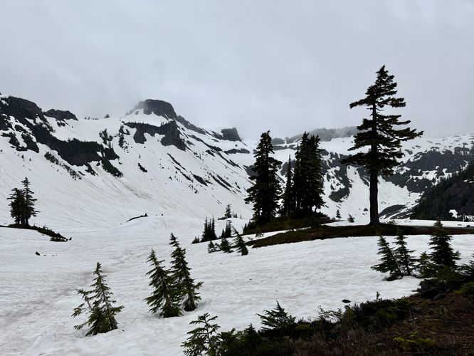
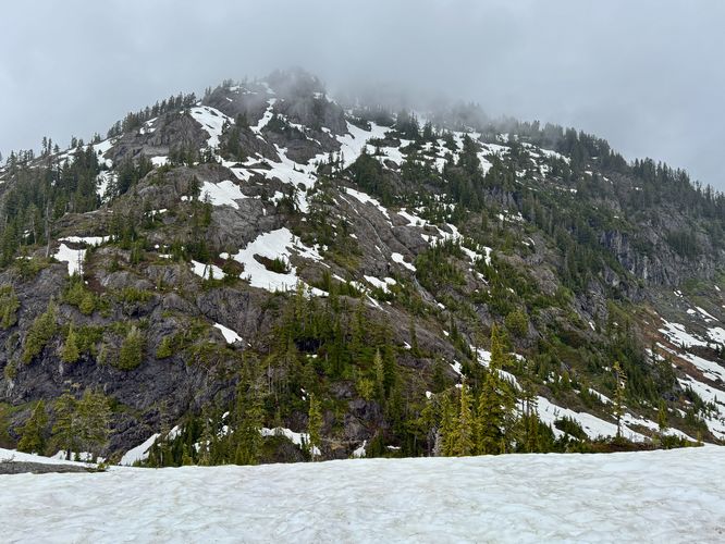
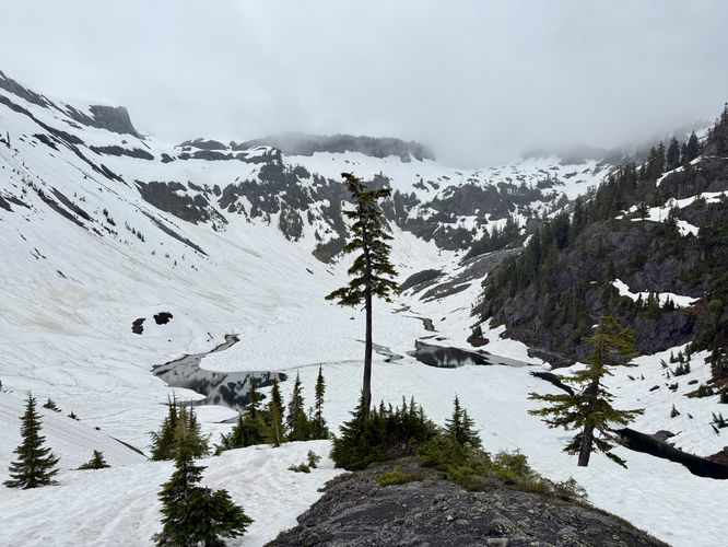
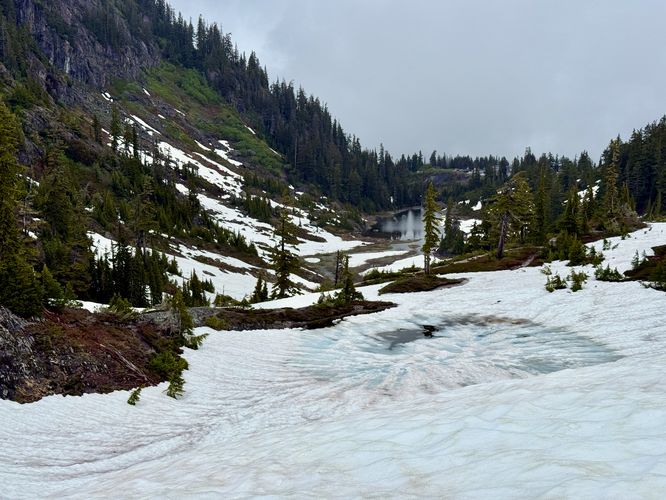
From the trailhead out to mile 0.2, you'll beautiful alpine views of Table Mountain with the backdrop of Mount Baker on clear days. During snow melt season and after period of rainfall, you'll likely find a massive waterfall tumbling down the southern slopes of Mount Herman to the north. And in the valley below sits the Bagley Lakes which are formed by snow and glacial melt from the higher elevations. Even if there's snow on the ground, the views of the mountains and dark-blue Bagley Lakes is well-worth a visit.

The pavement and universally-accessible portion of the trail ends around mile 0.2 as it follows a dirt path that circles around Terminal Lake. The trail dips into a small valley, passing Terminal Lake, and then ascends back to the parking lot for a short and easy 0.6-mile loop. 

Universal Access

This trail is partially universally-accessible. From the parking lot out to mile 0.19 / 0.2 near the overlook for the Bagley Lakes is accessible and follows a paved path. 

Parking

Hikers will find a large parking lot at the coordinates provided, located near the Heather Meadows visitor center. The lot is large enough to fit several dozen vehicles as of June 2025. Depending on the time of year that you visit, the parking lot may not be accessible to vehicles.

Pets

Dogs are allowed only if leashed and must be cleaned up after.

Seasonal Road Closures

The Mt. Baker Highway is subject to seasonal road closures. Before heading out, make sure you check current road statuses which can be found https://www.fs.usda.gov/r06/mbs/alerts. Another thing to note is that in the late spring and early summer, you will likely need to hike through the snow via the Heather Meadows & Bagley Lakes Hike to reach this trail.

Warning

Snowpack: If you plan to hike this trail when there's a few feet of snowpack on the ground, be aware of a couple of things. First, postholing is real, you don't want to be trudging through hip-deep snow full of pockets. Last, the snowpack near Terminal Lake can be more dangerous than it looks as the snow melt from higher elevations flows down into Terminal Lake, making for more dangerous potential to posthole into pockets of deep wet snow or even temporary creeks.
Explore 15 trails near Glacier, WA
  1. Parking

    48.854378, -121.68583
  2. Main Trailhead

    48.854146, -121.685976
  3. Cloudy view of Table Mountain

    48.854103, -121.686272
    Cloudy view of Table Mountain
  4. View of a massive waterfall tumbling down Mount Herman

    48.854194, -121.686775
    View of a massive waterfall tumbling down Mount Herman
  5. View of Bagley Lake and Table Mountain

    48.85345, -121.689667
    View of Bagley Lake and Table Mountain
  6. Blue hues of the frozen over Austin Pass Lake

    48.853919, -121.688239
    Blue hues of the frozen over Austin Pass Lake
No community routes found. To add your own hike as a Community Route for this Trail guide, leave a Trip Report with an attached GPX file.

Seasons

All

Trip Reports

Trail Guide By:
Admin user profile picture
0.6 miles / 1.0 km
Preview of the MyHikes mobile app interface

Track, Log, and Explore Hikes with the MyHikes App

Shop Landscape Prints
Shop our Washington State landscape prints

Weather Forecast

In Glacier, WA

Explore Hiking Trails

You May Also Like

Colorado's Million Dollar Highway - Plan a day's drive adventure along the iconic Million Dollar Highway in Colorado. Explore the best short trails, roadside stops, waterfalls, vistas, ghost towns, and hot springs within a ~6 hour road trip.
Explore

Colorado's Million Dollar Highway

Plan a day's drive adventure along the iconic Million Dollar Highway in Colorado. Explore the best short trails, roadside stops, waterfalls, vistas, ghost towns, and hot springs within a ~6 hour road trip.

Read
Glacier's Going-to-the-Sun Road - Discover the breathtaking beauty of Glacier National Park along the iconic Going-to-the-Sun Road. From stunning roadside stops to picturesque waterfalls and vistas, this engineering marvel offers endless opportunities for exploration.
Explore

Glacier's Going-to-the-Sun Road

Discover the breathtaking beauty of Glacier National Park along the iconic Going-to-the-Sun Road. From stunning roadside stops to picturesque waterfalls and vistas, this engineering marvel offers endless opportunities for exploration.

Read
New York's Best Waterfalls - Whether you're planning a day hike, roadside stop, or a leisurely short walk, this guide provides hikers, travelers, and locals alike with 63 different locations to over 100 scenic waterfalls to help plan your next adventure!
Explore

New York's Best Waterfalls

Whether you're planning a day hike, roadside stop, or a leisurely short walk, this guide provides hikers, travelers, and locals alike with 63 different locations to over 100 scenic waterfalls to help plan your next adventure!

Read

Before you boogie...

Find our trail guides useful? Consider becoming a Supporter to unlock perks!

MyHikes is an indie platform that makes exploring public trails easier for everyone. The platform has no investors, no ads, and is owned and operated by one person, Dave Miller. Dave has personally mapped and written over 1,800 trail guides on MyHikes for the public to explore. MyHikes has helped millions outdoor enthusiasts plan their next adventure.

But it takes a lot of time ๐Ÿ•ฆ, money ๐Ÿ’ฐ, work, and espresso shots โ˜• to run MyHikes, including hiking , mapping , writing , and publishing new trails with high-quality (accurate) information... along with software engineering (coding) the platform like building new features, website and mobile app development (iOS and Android), site maintainance . and much much more.

Supporters unlock website and mobile app perks with an annual one-time payment of $25 (you renew) ๐Ÿ˜Ž๐Ÿ‘. Or you can simply make a Donation of your choice. Otherwise, you can support us by telling your friends about MyHikes - both quick and free ๐ŸŽ‰

Admin user profile picture

Dave Miller
MyHikes Founder