Loading...

🎉 Enjoy a Free 7-Day Supporter Trial and Unlock Exclusive Perks — No Credit Card Required. Learn more.

Falls Ridge Hike

Directions
Map
Pictures
Send to App
Distance:
6.3 Miles / 10.1 km
Type:
Loop
Difficulty:
Moderate
Time to Hike:
3 hours, ~9 minutes
Features:
Surface Type:
Dirt
Park:
George Washington National Forest
Town:
Shenandoah County, Virginia
Directions:
38.895383, -78.740893
Added:
January 25, 2025
Updated:
April 04, 2025
Copy Trail Link Hiking this trail? Send a friend or family member a link to this trail guide for your own safety. Hike at your own risk (disclaimer)
Loading...
Loading...
1,433'

Total Change
1,599'

Ascent
1,586'

Descent

Download the Trail Route for Offline Use

Supporters get exclusive access to download trail routes to the MyHikes app for offline use. Stay prepared on your adventure, even without an internet connection! Become a Supporter today to unlock this feature and hike with confidence.

Send to App

Falls Ridge Hike

How would you like to have a beautiful 30ft waterfall all to yourself? Hidden off the Falls Ridge trail on an unofficial side trail, this beautiful waterfall is also unusual as it crashes into rocks next to a 60ft cliff instead of into a pool. In the summer standing under the falls is a great way to cool down on this hike. This circuit also has several great views along the Stack Rock Trail and North Mountain Ridge of Big Schloss and the valley below, as well as excellent car camping on FR252 along Lauren Run.

So why is the solitude so high on such a beautiful waterfall hike? There are a couple of reasons. 1. This hike is on the southern end of the Great North Mountain hiking area and away from the more popular Wolf Gap hikes. 2. FR252 is only open from April 1 - May 21 and Aug 1 - Dec 31. Although the hike and circuit can still be done when FR252 is closed by parking at the end of VA701/Dellinger Gap Rd. on the lower terminus of the yellow blazed Falls Ridge Trail. This will add 1 mile to the total hike length for 7.9 miles.

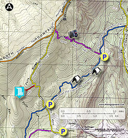
  • Mile 0.0 - From the parking area at the Stack Rock trailhead continue walking along FR252. FR252 is also blue blazed at this point as the Laurel Run Connector Trail. In 0.4 miles pass the first of 2 roadside camping spots, then in another 0.4 miles pass the second camp area. However if you are car camping the sites 1.5 miles earlier on FR252 next to Laurel Run are far superior. Continue walking along FR252 passing several nice views of the valley, then arrive at a parking area and closed gate blocking FR252 to motor vehicles.
  • Mile 1.8 - Pass around the closed gate and continue along FR252 on the blue blazed trail for 0.1 miles to the intersection where the yellow blazed Falls Ridge Trail crosses the road.
  • Mile 1.9 - Turn right uphill on the yellow blazed Falls Ridge Trail. The trail becomes increasingly more steep for the first 0.6 miles to the intersection of the unofficial side trail to the Falls Run waterfall.
  • Mile 2.5 - Look for a small rock cairn marking the side trail, however it is well worn and hard to miss. Turn left on the side trail that passes through Mountain Laurel. At this point the trail is intermittently marked with faint colored blazes. In 0.16 miles the trail will split.
  • Mile 2.8 - Turn left downhill (continuing straight will take you to the upper section of Falls Run). This section of the side trail is intermittently red blazed, but is harder to follow than the previous section. As you get closer to the run, the trail falls pass through a section of rhododendron then arrives at the waterfall and 60ft cliff. Pass carefully over the boulders down to the foot of the waterfall.
  • Mile 3.1 - Return back to the yellow blazed Falls Ridge Trail. Be cautious on the return after passing back through the rhoterdendrum. The trail is very faint and hard to follow.
  • Mile 3.9 - Turn left uphill on the yellow blazed Falls Ridge Trail. The Falls Ridge Trail will pass through another stand of Mountain Laurel before ending at the ridge and intersection of the North Mountain Trail.
  • Mile 5.15 - Turn right on the orange blazed North Mountain Trail for 100 yards and arrive at the Stack Rock Trail. Note: this intersection is easy to miss. If you start descending the ridge on the orange blazed trail you have gone too far.
  • Mile 5.18 - Turn right downhill on the purple blazed Stack Rock Trail. The Stack Rock Trail steeply descends North Mountain making multiple switchbacks. In 1.0 miles on the descent there is a good view to the north of Big Schloss as well as the valley. Continue downward where the trail will become less steep.
  • Mile 6.2 - Arrive back at the parking area on FR252.
Explore 78 trails near Shenandoah County, VA
  1. Parking

    38.895383, -78.740893
  2. Main Trailhead

    38.895507, -78.740945
No community routes found. To add your own hike as a Community Route for this Trail guide, leave a Trip Report with an attached GPX file.

Hazards

Ticks - Lyme Disease More Info (CDC)
Snakes
Poison Ivy/Oak

Seasons

All

Trip Reports

Trail Guide By:
HikingUpward user profile picture
6.3 miles / 10.1 km

Weather Forecast

In Shenandoah County, VA

Explore Hiking Trails

You May Also Like

New York's Best Waterfalls - Whether you're planning a day hike, roadside stop, or a leisurely short walk, this guide provides hikers, travelers, and locals alike with 63 different locations to over 100 scenic waterfalls to help plan your next adventure!
Explore

New York's Best Waterfalls

Whether you're planning a day hike, roadside stop, or a leisurely short walk, this guide provides hikers, travelers, and locals alike with 63 different locations to over 100 scenic waterfalls to help plan your next adventure!

Read
25 Best Day Hikes in North Carolina - Discover the top 25 best day hikes in North Carolina, from breathtaking waterfalls to mountain peaks. Explore hidden gems, scenic views, and trails suitable for all skill levels, perfect for your next outdoor adventure.
Explore

25 Best Day Hikes in North Carolina

Discover the top 25 best day hikes in North Carolina, from breathtaking waterfalls to mountain peaks. Explore hidden gems, scenic views, and trails suitable for all skill levels, perfect for your next outdoor adventure.

Read

Before you boogie...

Find our trail guides useful? Consider becoming a Supporter to unlock perks!

MyHikes is an indie platform that makes exploring public trails easier for everyone. The platform has no investors, no ads, and is owned and operated by one person, Dave Miller. Dave has personally mapped and written over 1,800 trail guides on MyHikes for the public to explore. MyHikes has helped millions outdoor enthusiasts plan their next adventure.

But it takes a lot of time 🕦, money 💰, work, and espresso shots ☕ to run MyHikes, including hiking , mapping , writing , and publishing new trails with high-quality (accurate) information... along with software engineering (coding) the platform like building new features, website and mobile app development (iOS and Android), site maintainance . and much much more.

Supporters unlock website and mobile app perks with an annual one-time payment of $25 (you renew) 😎👍. Or you can simply make a Donation of your choice. Otherwise, you can support us by telling your friends about MyHikes - both quick and free 🎉

Admin user profile picture

Dave Miller
MyHikes Founder