The Fallingwater Loop Trail at Frank Lloyd Wright's Fallingwater in Mill Run, Pennsylvania is an easy and extremely popular 0.9-mile loop trail that runs through the main grounds of the property. Please be advised that entry to the grounds costs $10 per adult as of April 2019.
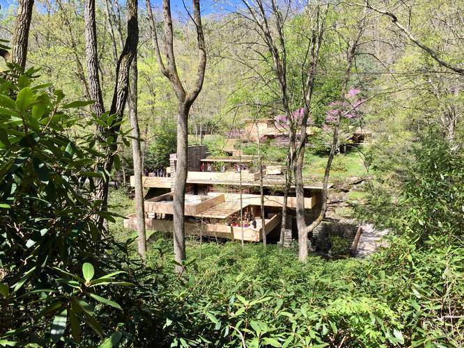
This recording starts at the parking lot outside of the visitors center at Fallingwater and follows a short spur trail that sits west of the visitors center with a dead-end and lookout point. The trail heads back towards the parking lot and then heads downhill along dozens of rhododenron before reaching another trail junction.
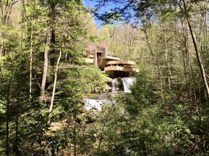
At the trail junction at the bottom of the hill, just below the first lookout point, is yet another short spur trail with a lookout point at the end - this is the best viewing area at Fallingwater, which often gets very crowded. From here you'll see the house with two beautiful waterfalls that cascade down Bear Run.
After visiting the best lookout, continue following the trail to Fallingwater itself and cross the bridge over Bear Run to hike up and behind the house. At the back of the house is a spur trail, the Paradise Overlook Trail, which is well worth a visit before continuing on the rest of this trail.
After visiting the back of Fallingwater and the Paradise Overlook Trail, follow the trail east by taking a left-hand turn after the bridge that crosses Bear Run. The trail will lead into a wildflower field while following Bear Run. There are a couple of places along the trail and creek where you can sit by the water and relax.
Finally, the trail heads uphill, passing rhododendron and following a wooden ramp up back to the visitors center, where this recording ends.
Fee: As of April 2019, there is a $10 per person fee to enter the grounds of Fallingwater. Read more on Fallingwater's website.
This recording starts at the parking lot outside of the visitors center at Fallingwater and follows a short spur trail that sits west of the visitors center with a dead-end and lookout point. The trail heads back towards the parking lot and then heads downhill along dozens of rhododenron before reaching another trail junction.
At the trail junction at the bottom of the hill, just below the first lookout point, is yet another short spur trail with a lookout point at the end - this is the best viewing area at Fallingwater, which often gets very crowded. From here you'll see the house with two beautiful waterfalls that cascade down Bear Run.
After visiting the best lookout, continue following the trail to Fallingwater itself and cross the bridge over Bear Run to hike up and behind the house. At the back of the house is a spur trail, the Paradise Overlook Trail, which is well worth a visit before continuing on the rest of this trail.
After visiting the back of Fallingwater and the Paradise Overlook Trail, follow the trail east by taking a left-hand turn after the bridge that crosses Bear Run. The trail will lead into a wildflower field while following Bear Run. There are a couple of places along the trail and creek where you can sit by the water and relax.
Finally, the trail heads uphill, passing rhododendron and following a wooden ramp up back to the visitors center, where this recording ends.
Fee: As of April 2019, there is a $10 per person fee to enter the grounds of Fallingwater. Read more on Fallingwater's website.