The Fall Brook Falls Trail at Tioga State Forest near Blossburg, Pennsylvania is a moderate 0.8-mile out-and-back hike that leads to the beautiful two-tiered waterfall, Fall Brook Falls.
Hikers will find that Fall Brook Falls is not a long hike nor a difficult hike, if you only wish to view the Upper tier of the waterfall, Upper Fall Brook Falls. The temptation of this hike is that Lower Fall Brook Falls is visible about 30-feet from Upper Fall Brook Falls, but is not accessible without hiking down a steep hill and back up stream, which can be dangerous. Hike at your own risk, but only experienced hikers should attempt to reach the lower tier of Fall Brook Falls.
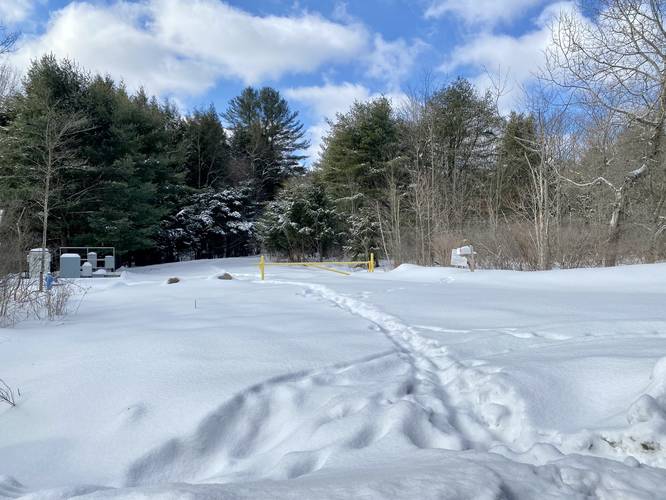
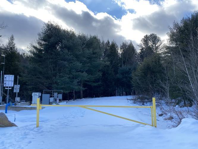
This hike begins at the yellow service gate and passes a large water pump station, which appears to be use to feed a neighboring reservoir. This water pump is capable of 0.999 million gallons per day or 700 gallons per minute, according to nearby signage.
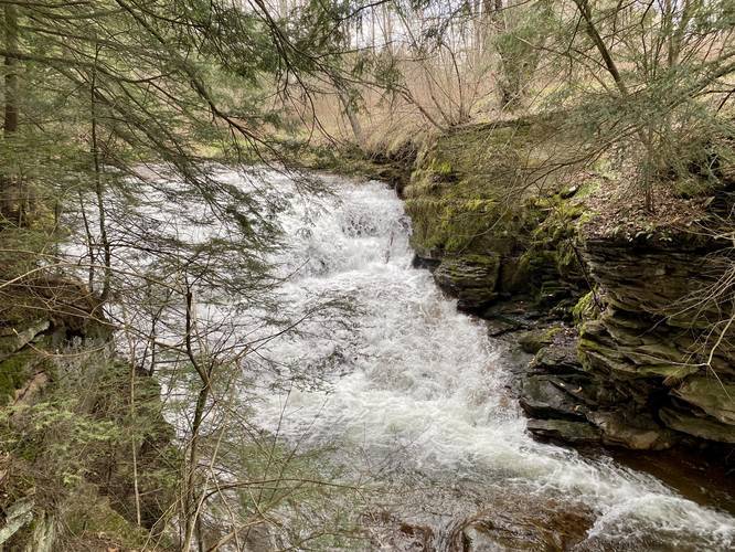
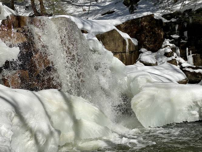
Shortly after crossing a stone bridge, the trail will run along Fall Brook as it heads gradually downhill. Once the trail begins heading downhill, there will be a metal fence with a view of Upper Fall Brook Falls. Here, hikers can take in the nice views of this approximately 10-foot tall slide waterfall.
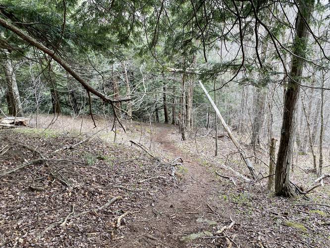
After visiting Upper Fall Brook Falls, the trail will head back uphill before leveling out. After hiking down this section of the trail, about 100-feet down the trail, will be a left-hand turn. Follow this trail downhill, following pink ribbons (April, 2020), to a large boulder that sits along Fall Brook - here, the recording heads up stream to reach the scenic Lower Fall Brook Falls.
From the bottom of the trail that leads down to Fall Brook Falls, hikers will meander their way up stream along the wet leaves, rocks, roots, and small ledges to reach Lower Fall Brook Falls. On this hike, during late April 2020, we found chunks of coal lying in the trail half-way to the waterfall, so it seems there may be a coal vein within the ravine as well.
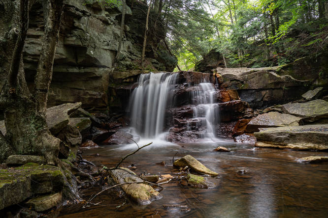
Once at Lower Fall Brook Falls, take in the sights and get your scenic waterfall photos before hiking back. The hike back uphill is not easy, but is not very long, so it's considered moderate. Again, the hike to the Lower falls can be dangerous, so hike at your own risk and only hike this section if you feel comfortable and experienced enough.
Fall Brook Falls
Fall Brook Falls is a two-tiered water fall where the Upper Falls is about 10-feet tall, which is a slide waterfall. The Lower Falls is about 8-feet tall, but is a free-falling waterfall. Lower Fall Brook Falls is located about 30-feet downstream from the Upper Falls.
Danger and Warning
Uneven terrain: Hikers should note that the second tier of Fall Brook Falls, aka Lower Fall Brook Falls, which is the most scenic of the two cascades, can only be accessed by hiking about 300-feet downstream from Upper Falls and then back up stream. The hike up stream to the Lower Fall Brook Falls is dangerous since rocks among the creek side can be wet slippery and slippery. Additionally, heavy rains can cause flash flooding, so watch the weather forecast.
Rattlesnakes: While rare, the Timber Rattlesnake lives in this area and tends to come down to creeks to cool down or hunt between the end of April through the end of September. Watch your step and give any rattlesnake you see some space.
Parking
Hikers will find a parking lot at the coordinates provided. The lot is large enough to accommodate about five vehicles.
Camping and Backpacking
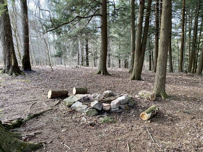
Backpackers will find there is a campsite near Fall Brook Falls (see the map). All campers and backpackers must follow the Tioga State Forest primitive/dispersed/backcountry camping rules.
Pets
Dogs are allowed if leashed and their waste must be carried out by the hiker.
Hikers will find that Fall Brook Falls is not a long hike nor a difficult hike, if you only wish to view the Upper tier of the waterfall, Upper Fall Brook Falls. The temptation of this hike is that Lower Fall Brook Falls is visible about 30-feet from Upper Fall Brook Falls, but is not accessible without hiking down a steep hill and back up stream, which can be dangerous. Hike at your own risk, but only experienced hikers should attempt to reach the lower tier of Fall Brook Falls.
This hike begins at the yellow service gate and passes a large water pump station, which appears to be use to feed a neighboring reservoir. This water pump is capable of 0.999 million gallons per day or 700 gallons per minute, according to nearby signage.
Shortly after crossing a stone bridge, the trail will run along Fall Brook as it heads gradually downhill. Once the trail begins heading downhill, there will be a metal fence with a view of Upper Fall Brook Falls. Here, hikers can take in the nice views of this approximately 10-foot tall slide waterfall.
After visiting Upper Fall Brook Falls, the trail will head back uphill before leveling out. After hiking down this section of the trail, about 100-feet down the trail, will be a left-hand turn. Follow this trail downhill, following pink ribbons (April, 2020), to a large boulder that sits along Fall Brook - here, the recording heads up stream to reach the scenic Lower Fall Brook Falls.
From the bottom of the trail that leads down to Fall Brook Falls, hikers will meander their way up stream along the wet leaves, rocks, roots, and small ledges to reach Lower Fall Brook Falls. On this hike, during late April 2020, we found chunks of coal lying in the trail half-way to the waterfall, so it seems there may be a coal vein within the ravine as well.
Once at Lower Fall Brook Falls, take in the sights and get your scenic waterfall photos before hiking back. The hike back uphill is not easy, but is not very long, so it's considered moderate. Again, the hike to the Lower falls can be dangerous, so hike at your own risk and only hike this section if you feel comfortable and experienced enough.
Fall Brook Falls
Fall Brook Falls is a two-tiered water fall where the Upper Falls is about 10-feet tall, which is a slide waterfall. The Lower Falls is about 8-feet tall, but is a free-falling waterfall. Lower Fall Brook Falls is located about 30-feet downstream from the Upper Falls.
Danger and Warning
Uneven terrain: Hikers should note that the second tier of Fall Brook Falls, aka Lower Fall Brook Falls, which is the most scenic of the two cascades, can only be accessed by hiking about 300-feet downstream from Upper Falls and then back up stream. The hike up stream to the Lower Fall Brook Falls is dangerous since rocks among the creek side can be wet slippery and slippery. Additionally, heavy rains can cause flash flooding, so watch the weather forecast.
Rattlesnakes: While rare, the Timber Rattlesnake lives in this area and tends to come down to creeks to cool down or hunt between the end of April through the end of September. Watch your step and give any rattlesnake you see some space.
Parking
Hikers will find a parking lot at the coordinates provided. The lot is large enough to accommodate about five vehicles.
Camping and Backpacking
Backpackers will find there is a campsite near Fall Brook Falls (see the map). All campers and backpackers must follow the Tioga State Forest primitive/dispersed/backcountry camping rules.
Pets
Dogs are allowed if leashed and their waste must be carried out by the hiker.