Loading...

🎉 Enjoy a Free 7-Day Supporter Trial and Unlock Exclusive Perks — No Credit Card Required. Learn more.

Emerald Pond Hike

Directions
Map
Pictures
Send to App
Distance:
8.3 Miles / 13.4 km
Type:
Loop
Difficulty:
Moderate
Time to Hike:
4 hours, ~9 minutes
Features:
Surface Type:
Dirt
Park:
George Washington National Forest
Town:
Stanley, Virginia
Directions:
38.642469, -78.61138
Added:
January 25, 2025
Updated:
April 12, 2025
Copy Trail Link Hiking this trail? Send a friend or family member a link to this trail guide for your own safety. Hike at your own risk (disclaimer)
Loading...
Loading...
1,150'

Total Change
1,538'

Ascent
1,556'

Descent

Download the Trail Route for Offline Use

Supporters get exclusive access to download trail routes to the MyHikes app for offline use. Stay prepared on your adventure, even without an internet connection! Become a Supporter today to unlock this feature and hike with confidence.

Send to App

Emerald Pond Hike

Emerald Pond is a beautiful spring fed swimming hole nestled in a small hollow off the Bird Knob Trail. The water has exceptional clarity, and in the summer months is surprisingly warm for a mountain pond. It practically begs you to jump in! But that's not the only feature on this circuit, just 1.5 miles into the hike on the Massanutten South Trail on Big Mountain is a spectacular vista to the west of the Harrisonburg Valley. Want to make this hike a little longer? Then try the Browns Hollow Hike that adds the Browns Hollow and Roaring Run Trails to make for a 8.3 mile circuit.

When backpacking there is a nice campsite right on the banks of Emerald Pond. Also if you travel west homeward towards I81, make sure to stop at Pack's Custard Stand on US211 in New Market for some of the best frozen custard around!

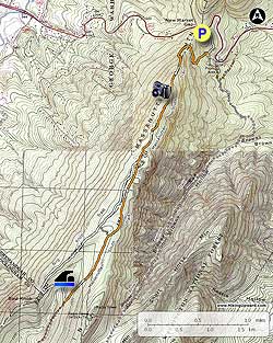
  • Mile 0.0 - Start the hike near the front of the parking area on the white blazed Wildflower Trail, DO NOT go down the paved Nature Trail at the end of the parking area. Follow the white blazed Wildflower Trail downhill for 0.3 miles to the intersection of the orange blazed Massanutten South Trail.
  • Mile 0.3 - Turn right uphill on the orange blazed trail for the steepest section of the hike. Wind around the mountain and climb through a bolder field before arriving at the lower ridgeline in 1.0 miles. Continue uphill for 0.4 miles to the first of two great vistas. This section of the hike is where you are most likely to run into other hikers, as many hikers do not do the entire Emerald Pond circuit, but instead do the much shorter out/back to the overlook.
  • Mile 1.7 - Continue on the Massanutten South Trail for 0.8 miles to the intersection of the white blazed Bird Knob Trail.
  • Mile 1.5 - Veer right on the now white blazed Bird Knob Trail, then shortly pass an unmaintained trail on the left. In another 0.7 miles stay right as you pass another unblazed trail that connects from the left. From this point it is 0.8 miles to a large clearing near Bird Knob. Bird Knob does not have an overlook as you may expect by the name. Stay left downhill on the Bird Knob Trail as it descends through the hollow to the intersection of an old logging road.
  • Mile 3.3 - Turn left on the old logging road for 0.1 miles and arrive at Emerald Pond. Pass along the left side of the pond following a small trail to a campsite on the opposite bank.
  • Mile 3.5 - Return to the white blazed Bird Knob Trail, turn left, then in 0.5 miles pass a closed gate.
  • Mile 4.0 - Turn left onto a Forestry Service road that is also the orange blazed Massanutten south Trail for 0.4 miles to the point where the road makes a hairpin turn to the right.
  • Mile 4.4 - Stay straight passing a closed gate and continuing on the orange blazed Massanutten South Trail. In 0.6 miles from the Forestry Service road arrive at an unmarked intersection, stay right remaining on the orange blazed trail, then in 0.8 miles pass through a small clearing and arrive back at the Bird Knob Trail intersection.
  • Mile 6.2 - Turn right orange blazed Massanutten South Trail retracing your route back past the two vistas, then descending to the white blazed Wildflower Trail.
  • Mile 8.3 - Turn left on the white blazed Wildflower Trail for the remaining 0.3 miles back to the parking area and now closed Visitor Center.
Explore 104 trails near Stanley, VA
  1. Parking

    38.642469, -78.61138
  2. Main Trailhead

    38.642546, -78.611147
No community routes found. To add your own hike as a Community Route for this Trail guide, leave a Trip Report with an attached GPX file.

Hazards

Ticks - Lyme Disease More Info (CDC)
Snakes
Poison Ivy/Oak

Seasons

All

Blaze Color

Orange

Trip Reports

Trail Guide By:
HikingUpward user profile picture
8.3 miles / 13.4 km

Weather Forecast

In Stanley, VA

Explore Hiking Trails

You May Also Like

New York's Best Waterfalls - Whether you're planning a day hike, roadside stop, or a leisurely short walk, this guide provides hikers, travelers, and locals alike with 63 different locations to over 100 scenic waterfalls to help plan your next adventure!
Explore

New York's Best Waterfalls

Whether you're planning a day hike, roadside stop, or a leisurely short walk, this guide provides hikers, travelers, and locals alike with 63 different locations to over 100 scenic waterfalls to help plan your next adventure!

Read
25 Best Day Hikes in North Carolina - Discover the top 25 best day hikes in North Carolina, from breathtaking waterfalls to mountain peaks. Explore hidden gems, scenic views, and trails suitable for all skill levels, perfect for your next outdoor adventure.
Explore

25 Best Day Hikes in North Carolina

Discover the top 25 best day hikes in North Carolina, from breathtaking waterfalls to mountain peaks. Explore hidden gems, scenic views, and trails suitable for all skill levels, perfect for your next outdoor adventure.

Read

Before you boogie...

Find our trail guides useful? Consider becoming a Supporter to unlock perks!

MyHikes is an indie platform that makes exploring public trails easier for everyone. The platform has no investors, no ads, and is owned and operated by one person, Dave Miller. Dave has personally mapped and written over 1,800 trail guides on MyHikes for the public to explore. MyHikes has helped millions outdoor enthusiasts plan their next adventure.

But it takes a lot of time 🕦, money 💰, work, and espresso shots ☕ to run MyHikes, including hiking , mapping , writing , and publishing new trails with high-quality (accurate) information... along with software engineering (coding) the platform like building new features, website and mobile app development (iOS and Android), site maintainance . and much much more.

Supporters unlock website and mobile app perks with an annual one-time payment of $25 (you renew) 😎👍. Or you can simply make a Donation of your choice. Otherwise, you can support us by telling your friends about MyHikes - both quick and free 🎉

Admin user profile picture

Dave Miller
MyHikes Founder