Loading...

🔥 End of Summer sale! 50% off on Supporter Accounts — now through September 1st. Learn More.

Browns Hollow Hike

Directions
Map
Pictures
Send to App
Distance:
10.7 Miles / 17.2 km
Type:
Out-and-Back
Difficulty:
Hard
Time to Hike:
5 hours, ~21 minutes
Features:
Surface Type:
Dirt
Park:
George Washington National Forest
Town:
Stanley, Virginia
Directions:
38.64278, -78.61138
Added:
January 24, 2025
Updated:
April 04, 2025
Guide by:
Copy Trail Link Hiking this trail? Send a friend or family member a link to this trail guide for your own safety. Hike at your own risk (disclaimer)
Loading...
Loading...
1,517'

Total Change
2,673'

Ascent
2,690'

Descent

Download the Trail Route for Offline Use

Supporters get exclusive access to download trail routes to the MyHikes app for offline use. Stay prepared on your adventure, even without an internet connection! Become a Supporter today to unlock this feature and hike with confidence.

Send to App

Key Takeaways

  • The Browns Hollow hike is a challenging 11.7-mile loop near Stanley, VA, offering a variety of scenic features including Browns Run gorge, Emerald Pond, and a vista of New Market.
  • The trail includes varied terrain, with climbs through gorges, steep ascents to ridges, and descents through rocky areas, requiring hikers to follow specific blazes and turns at intersections.
  • There are several campsites along the trail, particularly near Browns Run and Emerald Pond, and the option to visit Pack's Custard Stand in New Market after the hike.

Browns Hollow Hike

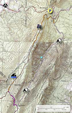
The Browns Hollow hike is the big brother to the Emerald Pond circuit, adding 3.5 miles with the addition of the Browns Hollow and Roaring Run Trails. This 11.7 mile hike has 3 great features: 1. The climb through the gorge on Browns Run, with small pools and waterfalls. 2. Emerald Pond, with its spring fed swimming hole nestled in a small hollow off the Bird Knob Trail. The water has exceptional clarity, and in the summer months is surprisingly warm for a mountain pond. And 3. A spectacular vista to the west of New Market from the Massanutten South Trail.

There are several secluded campsites along Browns Run, including one just above a set of falls halfway up the gorge. On the west side of Big Mountain the best camping is right on the banks of Emerald Pond. Also, if you travel west homeward, make sure to stop at Pack's Custard Stand on US211 in New Market for some of the best frozen custard around!

  • Mile 0.0 - Start the hike near the front of the parking area on the white blazed Wildflower Trail, DO NOT go down the paved Nature Trail at the end of the parking area. Follow the white blazed Wildflower Trail downhill for 0.3 miles to the intersection of the orange blazed Massanutten South Trail.
  • Mile 0.3 - Stay straight continuing downhill on the now white and orange blazed Wildflower/Massanutten South Trail for 0.2 miles to a four way intersection at the old picnic ground. On the opposite side of the intersection is a shelter with multiple picnic tables.
  • Mile 0.6 - At the four way intersection turn right on the orange blazed Massanutten South Trail that now uses a section of the picnic ground loop road. In 375 feet stay on the orange blazed Massanutten South Trail by turning right off the loop road onto an old logging road. Follow the trail for 400 feet to an intersection where the orange blazed Massanutten South Trail turns left, and the pink blazed Browns Hollow Trail stays straight on the old logging road.
  • Mile 0.8 - Stay straight on the pink blazed Browns Hollow Trail to the next intersection in 0.5 miles
  • Mile 1.3 - Stay left on the now narrower pink blazed Browns Hollow Trail as the old logging road continues straight. Follow the trail as it winds around the ridge, then descends to Browns Run. Just before crossing Browns Run there is a campsite and small steam that falls of Big Mountain.
  • Mile 1.8 - Cross Browns Run and now start the ascent of the gorge. The trail gradually increases in incline and passes a small waterfall and several campsites. The last 1.2 miles to the saddle between Short Horse Mountain and Big Mountain becomes quite steep.
  • Mile 4.5 - At the saddle there is a campsite suitable for two tents on the right. The pink blazed Browns Hollow Trail now descends for 0.7 miles into Roaring Run Gap, then ends at the intersection of the Roaring Run Trail.
  • Mile 5.2 - Turn right uphill on the purple blazed Roaring Run Gap Trail. The trail steeply ascends to the ridge on Big Mountain with several switchbacks. At the ridge is a small campsite on the right. Descend Big Mountain for 0.4 miles where the Roaring Run trail ends at the Massanutten South Trail and Forestry Road.
  • Mile 6.2 - Turn right uphill on the orange blazed Forestry Road for 0.4 miles to a closed gate and the white blazed Bird Knob Trail.
  • Mile 6.7 - Turn left passing the gate onto the white blazed Bird Knob trail and follow it for 0.1 miles to a spilt in the old logging road. Take the unmarked road to the right for 0.1 miles then arrive at Emerald Pond. Pass along the left side of the pond following a small trail to a campsite on the opposite bank.
  • Mile 6.8 - Return to the white blazed Bird Knob Trail, turn right, and climb to a clearing near Bird Knob. Pass along the right side of the clearing where the Bird Knob Trail reenters the forest on the ridge of Massanutten Mountain. The Bird Knob Trail will gently climb, then descend past two unmaintained trails before ending at the intersection of the orange blazed Massanutten South Trail 1.8 miles from the clearing.
  • Mile 9.2 - Stay left on the orange blazed Massanutten South Trail for 0.8 miles to the panoramic vista west towards New Market.
  • Mile 10.0 - From the vista descend steeply for 0.4 miles where the trail passes through a rocky area on the west side of the mountain. From this point the trail is less steep, and turns back the east side of the mountain descending back to the intersection to the Wildflower Trail.
  • Mile 11.4 - Turn left upward on the white blazed Wildflower Trail for the reaming 0.3 miles back to the parking area.
  • Mile 11.7 - Arrive back at the old Visitor Center and parking area.
Explore 104 trails near Stanley, VA
  1. Parking

    38.64278, -78.61138
  2. Main Trailhead

    38.642383, -78.611255
No community routes found. To add your own hike as a Community Route for this Trail guide, leave a Trip Report with an attached GPX file.

Hazards

Ticks - Lyme Disease More Info (CDC)
Snakes
Poison Ivy/Oak

Seasons

All

Photo Albums

+ Add Photo Album

Upload your photos from the trail to help others know what to expect.

Trip Reports (Reviews)

Rated 3.77 out of 5 based on 30 ratings.
By: Glenn
10.7 miles / 17.2 km
July 27, 2019
Great hike and you will cross a lot of day hikers. We ran across a 50K that was occurring and had to step to the side to give way to a few runners, no biggie. NOTE* The pond is a favorite local water hole for the locals. We arrived with multiple families enjoying the pond on rafts etc. However, at 130am, a few drunk locals found their way to our campsite (on the opposite bank) and disregarding us (three tents) and continued to be obnoxious and loud. We did let them know we were trying to sleep. They finally left and once they hit the dirt road, they fired numerous 9mm shots in the middle of the night. *its the main reason why I carry when I hike.
Legacy Review
By: Patrick
10.7 miles / 17.2 km
April 21, 2019
I did this hike on Easter Sunday with some friends. It was a great hike and there are still some winter time views. The waterfalls and pools on the Browns Hollow Trail were incredible. I am giving this hike four stars due to the motorcyclist, we encountered on the Roaring Run Trail as we were making the climb to the ridge line. He tore up the trail pretty badly. I have let the forest rangers and PATC know about this individual.
Legacy Review
By: Monkshood
10.7 miles / 17.2 km
November 25, 2018
Great Hike, especially in the first half (clockwise) for the waters you hike along and in the second half for the views in the last stretch before you head back down to the parking lots. Regarding the Browns Hollow Trail: the maps I first reach for do not mark this trail. I was prepared for some bushwacking, but the trail is there and is well maintained. Like the preceding reviewer, I found it well marked and missed no turns. An alternate starting point is on the Massanutten Trail (416), where it crosses US-211, slightly to the east of the Wildflower Trail TH. There's an ample parking lot on the south side of US-211 at that point that can't be missed (neither can the access to 416). From this starting point, I clocked 13.1 miles, so slightly longer than the route described above.
Legacy Review

Weather Forecast

In Stanley, VA

Explore Hiking Trails

You May Also Like

New York's Best Waterfalls - Whether you're planning a day hike, roadside stop, or a leisurely short walk, this guide provides hikers, travelers, and locals alike with 63 different locations to over 100 scenic waterfalls to help plan your next adventure!
Explore

New York's Best Waterfalls

Whether you're planning a day hike, roadside stop, or a leisurely short walk, this guide provides hikers, travelers, and locals alike with 63 different locations to over 100 scenic waterfalls to help plan your next adventure!

Read
25 Best Day Hikes in North Carolina - Discover the top 25 best day hikes in North Carolina, from breathtaking waterfalls to mountain peaks. Explore hidden gems, scenic views, and trails suitable for all skill levels, perfect for your next outdoor adventure.
Explore

25 Best Day Hikes in North Carolina

Discover the top 25 best day hikes in North Carolina, from breathtaking waterfalls to mountain peaks. Explore hidden gems, scenic views, and trails suitable for all skill levels, perfect for your next outdoor adventure.

Read

Before you boogie...

Find our trail guides useful? Consider becoming a Supporter to unlock perks!

MyHikes is an indie platform that makes exploring public trails easier for everyone. The platform has no investors, no ads, and is owned and operated by one person, Dave Miller. Dave has personally mapped and written over 1,800 trail guides on MyHikes for the public to explore. MyHikes has helped millions outdoor enthusiasts plan their next adventure.

But it takes a lot of time 🕦, money 💰, work, and espresso shots ☕ to run MyHikes, including hiking , mapping , writing , and publishing new trails with high-quality (accurate) information... along with software engineering (coding) the platform like building new features, website and mobile app development (iOS and Android), site maintainance . and much much more.

Supporters unlock website and mobile app perks with an annual one-time payment of $25 (you renew) 😎👍. Or you can simply make a Donation of your choice. Otherwise, you can support us by telling your friends about MyHikes - both quick and free 🎉

Admin user profile picture

Dave Miller
MyHikes Founder