Loading...

🎉 Enjoy a Free 7-Day Supporter Trial and Unlock Exclusive Perks — No Credit Card Required. Learn more.

East Branch Stony Fork Falls

Directions
Map
Pictures
Send to App
Distance:
0.1 Miles / 0.2 km
Type:
Out-and-Back
Difficulty:
Easy
Time to Hike:
~5 minutes
Features:
PA Wilds
Surface Type:
Dirt
Park:
Tioga State Forest
Town:
Morris, Pennsylvania
Directions:
41.621348, -77.366339
Added:
March 27, 2023
Updated:
March 27, 2023
Copy Trail Link Hiking this trail? Send a friend or family member a link to this trail guide for your own safety. Hike at your own risk (disclaimer)
Loading...
Loading...
0'

Total Change
0'

Ascent
0'

Descent

Download the Trail Route for Offline Use

Supporters get exclusive access to download trail routes to the MyHikes app for offline use. Stay prepared on your adventure, even without an internet connection! Become a Supporter today to unlock this feature and hike with confidence.

Send to App

East Branch Stony Fork Falls

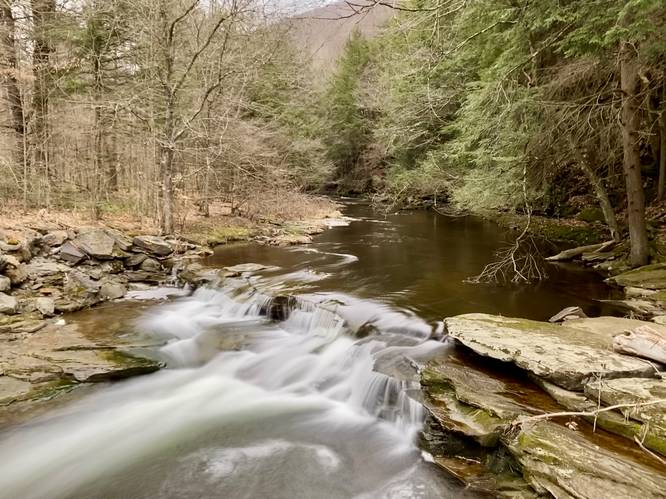
East Branch Stony Fork Falls at Tioga State Forest near Morris, Pennsylvania is an easy 0.1-mile out-and-back roadside walk that leads to the 3-foot tall, 15-foot wide Stony Fork Falls.

This is not a hike but rather a quick walk that leads down Stony Fork Creek Road to the bridge that crosses Stony Fork. The waterfall cascades down the bedrock at about 3-feet tall and ~15-feet wide. While this waterfall is nothing spectacular, fisher-folk, tourists, and visitors alike will find this cascade to be scenic nonetheless.

Parking
There's a small parking turnout located to the south of the bridge, at the coordinates provided. It's large enough to fit a couple of vehicles. You can also find another small parking turnout north of the bridge too.

Pets
Dogs are allowed if leashed and must be cleaned up after.

Fishing
This waterfall is great for fishing since it's located right off of the road. Please follow all state and state forest rules and regulations when fishing.
Explore 284 trails near Morris, PA
  1. Parking

    41.621348, -77.366339
  2. Main Trailhead

    41.621333, -77.366318
  3. East Branch Stony Fork Falls (3-feet tall, 15-feet wide)

    41.621539, -77.366006
    East Branch Stony Fork Falls (3-feet tall, 15-feet wide)
No community routes found. To add your own hike as a Community Route for this Trail guide, leave a Trip Report with an attached GPX file.

Hazards

Ticks - Lyme Disease More Info (CDC)
Snakes

Seasons

All

Weather Forecast

In Morris, PA

Explore Hiking Trails

You May Also Like

Colorado's Million Dollar Highway - Plan a day's drive adventure along the iconic Million Dollar Highway in Colorado. Explore the best short trails, roadside stops, waterfalls, vistas, ghost towns, and hot springs within a ~6 hour road trip.
Explore

Colorado's Million Dollar Highway

Plan a day's drive adventure along the iconic Million Dollar Highway in Colorado. Explore the best short trails, roadside stops, waterfalls, vistas, ghost towns, and hot springs within a ~6 hour road trip.

Read
New York's Best Waterfalls - Whether you're planning a day hike, roadside stop, or a leisurely short walk, this guide provides hikers, travelers, and locals alike with 63 different locations to over 100 scenic waterfalls to help plan your next adventure!
Explore

New York's Best Waterfalls

Whether you're planning a day hike, roadside stop, or a leisurely short walk, this guide provides hikers, travelers, and locals alike with 63 different locations to over 100 scenic waterfalls to help plan your next adventure!

Read

Before you boogie...

Find our trail guides useful? Consider becoming a Supporter to unlock perks!

MyHikes is an indie platform that makes exploring public trails easier for everyone. The platform has no investors, no ads, and is owned and operated by one person, Dave Miller. Dave has personally mapped and written over 1,800 trail guides on MyHikes for the public to explore. MyHikes has helped millions outdoor enthusiasts plan their next adventure.

But it takes a lot of time 🕦, money 💰, work, and espresso shots ☕ to run MyHikes, including hiking , mapping , writing , and publishing new trails with high-quality (accurate) information... along with software engineering (coding) the platform like building new features, website and mobile app development (iOS and Android), site maintainance . and much much more.

Supporters unlock website and mobile app perks with an annual one-time payment of $25 (you renew) 😎👍. Or you can simply make a Donation of your choice. Otherwise, you can support us by telling your friends about MyHikes - both quick and free 🎉

Admin user profile picture

Dave Miller
MyHikes Founder