Loading...

🔥 End of Summer sale! 50% off on Supporter Accounts — now through September 1st. Learn More.

Double Bear Rocks Hike

Directions
Map
Pictures
Send to App
Distance:
8.2 Miles / 13.2 km
Type:
Out-and-Back
Difficulty:
Moderate
Time to Hike:
4 hours, ~6 minutes
Features:
Appalachian Trail hike
Surface Type:
Dirt
Park:
Shenandoah National Park
Town:
Sperryville, Virginia
Directions:
38.66855, -78.289994
Added:
March 18, 2025
Updated:
April 05, 2025
Guide by:
Copy Trail Link Hiking this trail? Send a friend or family member a link to this trail guide for your own safety. Hike at your own risk (disclaimer)
Loading...
Loading...
1,651'

Total Change
1,791'

Ascent
1,790'

Descent

Download the Trail Route for Offline Use

Supporters get exclusive access to download trail routes to the MyHikes app for offline use. Stay prepared on your adventure, even without an internet connection! Become a Supporter today to unlock this feature and hike with confidence.

Send to App

Double Bear Rocks Hike

With such diverse scenery, it's surprising the Pass Mountain Trail is one of the least used in the central Shenandoah National Park. With a pleasant forest walk along the ridge, and nice views of Mary's Rock, the trail ends at the Pass Mountain Shelter. From there it's a short walk along the AT over the summit of Pass Mountain down to Double Bear Rocks with beautiful views westward of New Market Gap, Luray, and Strickler Knob. Double Bear Rocks is another hidden SNP vista not many visit.
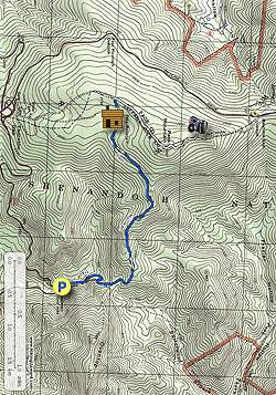
  • Mile 0.0 - From the parking area on VA211 CARFULLY cross the road and start the hike at the Pass Mountain Trail marker from the hairpin turn on VA211. The blue blazed trail heads uphill and gradually becomes steeper and making 2 hard switch backs before arriving at the ridge and old trail post for the now abandoned fire road trail in 0.9 miles.
  • Mile 0.9 - Stay left continuing on the blue blazed Pass Mountain Trail as it follows the ridge. There are several good views of Mary's Rock on the other side of Thornton River through the trees. At 1.9 miles the trail turns left and levels out for 0.7 miles, turns right, then climbs to the Pass Mountain Shelter.
  • Mile 2.8 - The Pass Mountain Shelter has both a high and low bunk with 2 outhouses. Several years ago a nuisance bear in the area had to be transported to another section of the SNP and after that incident steel bear boxes have been installed. There are 2 side trails on the right of the shelter, one leads to a spring, and the other to a tent camp area. From the shelter an access road splits to the left, stay right uphill on the blue connector trail then in 0.25 arrive at the intersection of the Appalachian Trail (AT).
  • Mile 3.05 - Turn right on the AT and shortly pass through a stand of medium sized pine. Continue at a slightly steeper grade and crest the summit of Pass Mountain. There are no views here.
  • Mile 3.72 - Descend the summit of Pass Mountain and follow the AT for another 0.53 miles to Double Bear Rocks overlook. There is no signage marking the overlook, look for a side trial on the left of the AT that leads 25 yards down to Double Bear Rocks.
  • Mile 4.25 - At Double Bear Rocks there are expansive views west of the Luray Valley, New Market Gap, and Massanutten Range, with Strickler Knob and Kennedy Peak visible on a clear day. Retrace your route back to the parking area.
  • Mile 8.2 - Arrive back at the parking area on VA211.
Explore 92 trails near Sperryville, VA
  1. Parking

    38.66855, -78.289994
  2. Main Trailhead

    38.668356, -78.289819
No community routes found. To add your own hike as a Community Route for this Trail guide, leave a Trip Report with an attached GPX file.

Hazards

Ticks - Lyme Disease More Info (CDC)
Snakes
Poison Ivy/Oak

Seasons

All

Blaze Color

Blue

Trip Reports (Reviews)

Rated 3.2 out of 5 based on 10 ratings.
By: bushWhacker
8.2 miles / 13.2 km
September 22, 2019
Trail looks like it has not been used much this summer. Entrance is way overgrown (when you walk out of the parking lot cross 211 and "turn left" towards the hairpin turn, look for a trail post on your right before the guardrail starts). The flat section of the hike before you get to the shelter is also very overgrown with grass, recommend pants and bug spray for sure. Went with 4 people and a dog, no ticks found after. Everything after the shelter is beautifully maintained, the view is easy to miss but quite lovely. Other random notes: -Lots of bear scat around -Shelter in good shape, as is it's outhouse -Lots of butterflies -Lots of spiderwebs on the trail My family likes a well groomed trail so this wasn't the best choice for them, but if you like a little adventure and seclusion this is a good one.
Legacy Review
By: nort
8.2 miles / 13.2 km
December 16, 2017
Nice hike, not very strenuous. I thought there might be better views with all the leaves down, but aside from the overlook there really weren't many/any views at all. It's a nice walk in the woods, though, and there were a couple inches of snow blanketing the north side of Pass Mt. The spring at the hut was just a trickle but it was running.
Legacy Review
By: AA
8.2 miles / 13.2 km
May 29, 2017
Steady uphill almost the entire way to the top, though it was not a terribly strenuous grade. There wasn't much as far as scenery to look at other than the woods, which is always nice. We went slowly though steadily and it took us about 4 hours to get to Double Bear Rocks. The view was minimal from the rock outcropping, but a nice place to sit for a bit and have a snack nonetheless. There was gorgeous pink mountain laurel blooming that was a special treat. The way back was almost entirely downhill other than a short section upward close to the outcropping and took about 2.5 hours. We saw a small orange salamander and a few flowers but not much else. Our fitbits all said 10 miles (plus some) by the time it was said and done, so we were questioning if the mileage listed on this is accurate, but who knows- those are not always accurate themselves.
Legacy Review

Weather Forecast

In Sperryville, VA

Explore Hiking Trails

You May Also Like

New York's Best Waterfalls - Whether you're planning a day hike, roadside stop, or a leisurely short walk, this guide provides hikers, travelers, and locals alike with 63 different locations to over 100 scenic waterfalls to help plan your next adventure!
Explore

New York's Best Waterfalls

Whether you're planning a day hike, roadside stop, or a leisurely short walk, this guide provides hikers, travelers, and locals alike with 63 different locations to over 100 scenic waterfalls to help plan your next adventure!

Read
25 Best Day Hikes in North Carolina - Discover the top 25 best day hikes in North Carolina, from breathtaking waterfalls to mountain peaks. Explore hidden gems, scenic views, and trails suitable for all skill levels, perfect for your next outdoor adventure.
Explore

25 Best Day Hikes in North Carolina

Discover the top 25 best day hikes in North Carolina, from breathtaking waterfalls to mountain peaks. Explore hidden gems, scenic views, and trails suitable for all skill levels, perfect for your next outdoor adventure.

Read

Before you boogie...

Find our trail guides useful? Consider becoming a Supporter to unlock perks!

MyHikes is an indie platform that makes exploring public trails easier for everyone. The platform has no investors, no ads, and is owned and operated by one person, Dave Miller. Dave has personally mapped and written over 1,800 trail guides on MyHikes for the public to explore. MyHikes has helped millions outdoor enthusiasts plan their next adventure.

But it takes a lot of time 🕦, money 💰, work, and espresso shots ☕ to run MyHikes, including hiking , mapping , writing , and publishing new trails with high-quality (accurate) information... along with software engineering (coding) the platform like building new features, website and mobile app development (iOS and Android), site maintainance . and much much more.

Supporters unlock website and mobile app perks with an annual one-time payment of $25 (you renew) 😎👍. Or you can simply make a Donation of your choice. Otherwise, you can support us by telling your friends about MyHikes - both quick and free 🎉

Admin user profile picture

Dave Miller
MyHikes Founder