The Double Arch Trail at Arches National Park near Moab, Utah is an easy 0.5-mile out-and-back hike that leads to the stunning duo of arches known as the Double Arch.
Hike Description
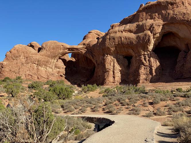
This short hike begins at the main parking lot for Double Arch, located at the end of Windows Road in the park. The trail is flat and easy to follow for most of the hike and provides views of Double Arch, starting at the trailhead. Hikers will find plenty of views without having to go too far, but the best views are from the base.
Double Arch View - Mile 0.25
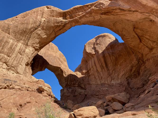
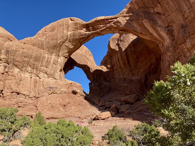
As you approach the arches, the trail will begin to follow bedrock along a loosely-defined path that you can take to reach the base or the center of the arches if you wish. A lot of hikers end up following the trail downhill and then back uphill to reach the center of the arches, but this track ends at the base to enjoy the scenery, located around mile 0.25. From the base of Double Arch, hikers get a grand view into the massive pothole-created rock arches.
How was Double Arch Formed?
This massive double arch probably started as two tiny puddles high atop a rock wall. Swirling water and debris ate away at the rock over time, deepening both puddles to pits that finally punched all the way through the cliff face. Arches formed that way are called "potholes arches." Eventually, whatever rock separated the two pothole arches also eroded away, creating the impressive formation you see today.
How to Get Into Arches National Park
Note that Arches National Park, as of September 2023 (and earlier) only allows vehicles to enter the park during scheduled time slots. You can read all about Arches' timed entry here and you can find reservation information here. Reservations are grabbed quickly, so be sure to log onto the reservation website when the date opens up to grab your timed entry ticket. Note that vehicles can enter the park outside of the timed entry slots (i.e. before 7AM or after 4PM each day, as of September 2023). If you do not have a timed entry ticket between 7AM and 4PM, do not wait in line to enter the park as you will be turned away and will slow everyone else down. The vehicle line to enter the park is very long and wait-times to enter can be a pain so show up prepared.
Parking
Hikers will find a massive parking lot at the coordinates provided at the end of Windows Road in Arches National Park. The lot is large enough to fit several dozen vehicles. Parking here fills up very quickly -- generally by late morning.
Popularity
This is a very-popular hike at Arches National Park, so you'll likely see plenty of other people on the trail.
Pets
Dogs are not allowed on any trails at Arches National Park. Please do not bring your dog here.
Fees
As of September 2023, there's a $30 fee per vehicle to enter Arches National Park.
Warnings
Sun exposure: This trail has very little shade and no water sources. Pack-in all water and wear sun screen and a hat to protect against sun exposure. It's smart to hike either in the early morning or late afternoon to avoid the intense desert sun.
No water: This trail has no water sources so you must pack-in all water. A general rule of thumb in the desert is 1 gallon of water per person per day.
Rattlesnakes: This is rattlesnake territory, so be on the lookout and give any rattlers you find plenty of space.
Hike Description
This short hike begins at the main parking lot for Double Arch, located at the end of Windows Road in the park. The trail is flat and easy to follow for most of the hike and provides views of Double Arch, starting at the trailhead. Hikers will find plenty of views without having to go too far, but the best views are from the base.
Double Arch View - Mile 0.25
As you approach the arches, the trail will begin to follow bedrock along a loosely-defined path that you can take to reach the base or the center of the arches if you wish. A lot of hikers end up following the trail downhill and then back uphill to reach the center of the arches, but this track ends at the base to enjoy the scenery, located around mile 0.25. From the base of Double Arch, hikers get a grand view into the massive pothole-created rock arches.
How was Double Arch Formed?
This massive double arch probably started as two tiny puddles high atop a rock wall. Swirling water and debris ate away at the rock over time, deepening both puddles to pits that finally punched all the way through the cliff face. Arches formed that way are called "potholes arches." Eventually, whatever rock separated the two pothole arches also eroded away, creating the impressive formation you see today.
How to Get Into Arches National Park
Note that Arches National Park, as of September 2023 (and earlier) only allows vehicles to enter the park during scheduled time slots. You can read all about Arches' timed entry here and you can find reservation information here. Reservations are grabbed quickly, so be sure to log onto the reservation website when the date opens up to grab your timed entry ticket. Note that vehicles can enter the park outside of the timed entry slots (i.e. before 7AM or after 4PM each day, as of September 2023). If you do not have a timed entry ticket between 7AM and 4PM, do not wait in line to enter the park as you will be turned away and will slow everyone else down. The vehicle line to enter the park is very long and wait-times to enter can be a pain so show up prepared.
Parking
Hikers will find a massive parking lot at the coordinates provided at the end of Windows Road in Arches National Park. The lot is large enough to fit several dozen vehicles. Parking here fills up very quickly -- generally by late morning.
Popularity
This is a very-popular hike at Arches National Park, so you'll likely see plenty of other people on the trail.
Pets
Dogs are not allowed on any trails at Arches National Park. Please do not bring your dog here.
Fees
As of September 2023, there's a $30 fee per vehicle to enter Arches National Park.
Warnings
Sun exposure: This trail has very little shade and no water sources. Pack-in all water and wear sun screen and a hat to protect against sun exposure. It's smart to hike either in the early morning or late afternoon to avoid the intense desert sun.
No water: This trail has no water sources so you must pack-in all water. A general rule of thumb in the desert is 1 gallon of water per person per day.
Rattlesnakes: This is rattlesnake territory, so be on the lookout and give any rattlers you find plenty of space.