Loading...

๐ŸŽ† 50% off 4th of July sale on Supporter Accounts โ€” now through July 6! Learn More.

DOC Trail

Directions
Map
Pictures
Send to App
Distance:
1.0 Mile / 1.6 km
Type:
Out-and-Back
Difficulty:
Easy
Time to Hike:
~30 minutes
Features:
Surface Type:
Dirt
Park:
Mount Tom State Reservation
Town:
Holyoke, Massachusetts
Directions:
42.24205, -72.629948
Added:
June 20, 2019
Updated:
April 23, 2020
Copy Trail Link Hiking this trail? Send a friend or family member a link to this trail guide for your own safety. Hike at your own risk (disclaimer)
Loading...
Loading...
355'

Total Change
50'

Ascent
394'

Descent

Download the Trail Route for Offline Use

Supporters get exclusive access to download trail routes to the MyHikes app for offline use. Stay prepared on your adventure, even without an internet connection! Become a Supporter today to unlock this feature and hike with confidence.

Send to App

DOC Trail

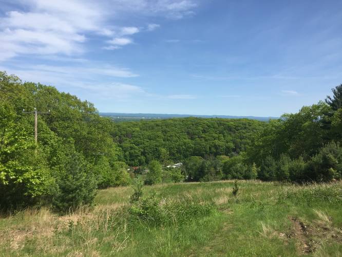
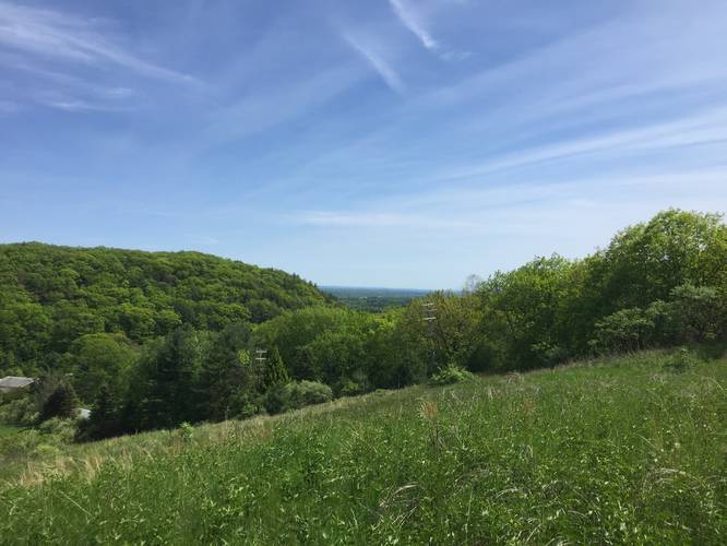
The DOC Trail at the Mount Tom State Reservation in Holyoke, Massachusetts is an easy 1-mile one-way trail that features a quiet walk through the forest near Whiting Peak.

This trailhead is located along the Tote Road Trail, just south of the summit of Whiting Peak on the the southern portion of the range. The DOC Trail heads up the mountain at a gradual elevation grade before continuing northeast, heading down the mountain, when it reaches the Metacomet-Monadnock Trail (M & M Trail) near Whiting Peak.

The DOC Trail connects easily to the Middle Loop Trail near the southern trailhead and in the northeast it meets up with the Quarry Trail and Keystone Trail.

Pets
Dogs are allowed if leashed and their waste must be carried out by the hiker.

Parking
Please note that the parking coordinates will bring hikers to the entrance to the southeastern section to the Mount Tom State Reservation. Depending on the time of year, this road can be closed up to a certain point to motorized vehicles. Hikers will find parking down this road, but how far is unpredictable - so plan on hiking down Mt Tom Ski Road until you reach the end of this trek to hike in the opposite direction.
Explore 206 trails near Holyoke, MA
  1. Parking

    42.24205, -72.629948
  2. Main Trailhead

    42.255457, -72.640751
  3. Vista point - not on the DOC Trail but leads up to it

    42.25285, -72.635772
    Vista point - not on the DOC Trail but leads up to it
  4. Vista point - not on the DOC Trail but leads up to it

    42.252183, -72.63465
    Vista point - not on the DOC Trail but leads up to it
No community routes found. To add your own hike as a Community Route for this Trail guide, leave a Trip Report with an attached GPX file.

Hazards

Ticks - Lyme Disease More Info (CDC)
Snakes

Seasons

All

Blaze Dot

Red

Weather Forecast

In Holyoke, MA

Explore Hiking Trails

You May Also Like

Colorado's Million Dollar Highway - Plan a day's drive adventure along the iconic Million Dollar Highway in Colorado. Explore the best short trails, roadside stops, waterfalls, vistas, ghost towns, and hot springs within a ~6 hour road trip.
Explore

Colorado's Million Dollar Highway

Plan a day's drive adventure along the iconic Million Dollar Highway in Colorado. Explore the best short trails, roadside stops, waterfalls, vistas, ghost towns, and hot springs within a ~6 hour road trip.

Read
Glacier's Going-to-the-Sun Road - Discover the breathtaking beauty of Glacier National Park along the iconic Going-to-the-Sun Road. From stunning roadside stops to picturesque waterfalls and vistas, this engineering marvel offers endless opportunities for exploration.
Explore

Glacier's Going-to-the-Sun Road

Discover the breathtaking beauty of Glacier National Park along the iconic Going-to-the-Sun Road. From stunning roadside stops to picturesque waterfalls and vistas, this engineering marvel offers endless opportunities for exploration.

Read
New York's Best Waterfalls - Whether you're planning a day hike, roadside stop, or a leisurely short walk, this guide provides hikers, travelers, and locals alike with 63 different locations to over 100 scenic waterfalls to help plan your next adventure!
Explore

New York's Best Waterfalls

Whether you're planning a day hike, roadside stop, or a leisurely short walk, this guide provides hikers, travelers, and locals alike with 63 different locations to over 100 scenic waterfalls to help plan your next adventure!

Read

Before you boogie...

Find our trail guides useful? Consider becoming a Supporter to unlock perks!

MyHikes is an indie platform that makes exploring public trails easier for everyone. The platform has no investors, no ads, and is owned and operated by one person, Dave Miller. Dave has personally mapped and written over 1,800 trail guides on MyHikes for the public to explore. MyHikes has helped millions outdoor enthusiasts plan their next adventure.

But it takes a lot of time ๐Ÿ•ฆ, money ๐Ÿ’ฐ, work, and espresso shots โ˜• to run MyHikes, including hiking , mapping , writing , and publishing new trails with high-quality (accurate) information... along with software engineering (coding) the platform like building new features, website and mobile app development (iOS and Android), site maintainance . and much much more.

Supporters unlock website and mobile app perks with an annual one-time payment of $25 (you renew) ๐Ÿ˜Ž๐Ÿ‘. Or you can simply make a Donation of your choice. Otherwise, you can support us by telling your friends about MyHikes - both quick and free ๐ŸŽ‰

Admin user profile picture

Dave Miller
MyHikes Founder