Loading...

🔥 End of Summer sale! 50% off on Supporter Accounts — now through September 1st. Learn More.

Difficult Run Hike

Directions
Map
Pictures
Send to App
Distance:
4.9 Miles / 7.9 km
Type:
Loop
Difficulty:
Easy
Time to Hike:
2 hours, ~27 minutes
Features:
Surface Type:
Dirt
Town:
McLean, Virginia
Directions:
38.978135, -77.248863
Added:
April 03, 2025
Updated:
April 06, 2025
Guide by:
Copy Trail Link Hiking this trail? Send a friend or family member a link to this trail guide for your own safety. Hike at your own risk (disclaimer)
Loading...
Loading...
204'

Total Change
616'

Ascent
616'

Descent

Download the Trail Route for Offline Use

Supporters get exclusive access to download trail routes to the MyHikes app for offline use. Stay prepared on your adventure, even without an internet connection! Become a Supporter today to unlock this feature and hike with confidence.

Send to App

Difficult Run Hike

With fifty percent of the Difficult Run hike following the Potomac River at one of its most scenic spots, it's easy to see why so many people make Great Falls Park one of their favorite local hikes. Difficult Run drops over several small waterfalls as it winds its way to the Potomac River, where the Potomac River passes through a deep gorge with fast moving water. Just 2.8 miles from the Scott's Run Nature Preserve, this is one of two scenic loop hikes just outside the Capital Beltway.

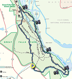
From the end of the parking area, take the Difficult Run Trail as it follows the run bank before passing under Georgetown Pike in 0.3 miles. Just after passing under Georgetown Pike, the trail will become wider as it continues along Difficult Run for another 0.9 miles and past the junction of the Ridge Trail on your left. Continue downhill past the Ridge Trail, where the Difficult Run Trail ends at the confluence of the Potomac River.

Return to the intersection of the Ridge Trail and turn right. Follow the trail to the top of the rise and turn left following the ridge. In 0.5 miles turn right downhill on the blue blazed River Trail as it steeply descends toward the Potomac River.

The trail is hard to spot in places because of blow downs, just follow the blue blazes. The trail passes over a small footbridge and a paved road, then continues just to the right on the other side.

Continue on the blue blazed trail as it follows the river before arriving at Patowmack Canal ruins. In 50 yards, turn right over the footbridge then left following the green blazed River Trail. The trail will descend over a large footbridge before arriving at the main picnic area of Great Falls Park. Stay right and pass the two main scenic overlooks at Great Falls Park.

Just past the second overlook, cross the footbridge turning left back through the picnic area. Stay right, then at the fork, bear left towards the bathroom facilities (right is a parking area). After passing the bathrooms, turn right onto the Old Carriage Road.

In 0.5 miles, turn right on the Swamp Trail. Follow the Swamp Trail for 0.4 miles where it ends at the next trail junction. Turn right climbing over the hill and in 0.3 miles the trail ends at the junction of the Ridge Trail.

Turn left, and in 60 yards, at the bottom of the depression, a small trail marked only by a single split rail post turns right downhill. Turn right on the trail as it heads down the ravine for the remaining 0.2 miles back to Georgetown Pike and the parking area.

Use Extreme Caution crossing Georgetown Pike back to the parking area.

Explore 19 trails near McLean, VA
  1. Parking

    38.978135, -77.248863
  2. Main Trailhead

    38.978261, -77.248821
No community routes found. To add your own hike as a Community Route for this Trail guide, leave a Trip Report with an attached GPX file.

Hazards

Ticks - Lyme Disease More Info (CDC)
Snakes
Poison Ivy/Oak

Seasons

All

Blaze Color

Blue

Trip Reports (Reviews)

Rated 3.93 out of 5 based on 45 ratings.
By: Cate
4.9 miles / 7.9 km
January 21, 2019
The Difficult Run Trail (at least where it meets the parking lot for this hike) is closed for repair. I wasn't sure what or where the issue was so I just reversed the directions for the above hike, crossed Georgetown Pike and started on the unmarked, but easy to spot trail that starts right across the street from the parking lot (Google Maps has it labeled as Wolfpack Trail). I went left where Wolfpack Trail dumps out onto Ridge Trail, right onto Swamp Trail, and left onto Old Carriage Road which took me to the overlooks. This shortens the hike to about 3 miles round trip, but the overlooks are amazing and totally worth it. Saw a few people, but was alone most of the time, probably thanks to the weather (16 degrees when I started out at 10:30am!!) While not blazed, the trails are easy to follow in most places. There are several parts where the trail is iced over so watch your step!
Legacy Review
By: cmg
4.9 miles / 7.9 km
June 03, 2017
We started at 9am at the Georgetown Pike parking lot. There's actually 3 trails that meet there, take the farthest east trail entrance that has a small sign post (not the trail with the large cross county map and not the trail across Georgetown Pike. Get to the parking lot early it was almost full at 9am on Saturday when we started. This hike took us about 5 hours but we stopped for lunch at the picnic area near the bathrooms and checked out most of the overlooks and small paths by the river. Everything is well signed but the blaze is now green instead of blue. Definitely take the Swamp Trail since we saw maybe two people on that trail and it was quite beautiful. I'll try this hike again in Fall/Winter to see the views without the leaves- perhaps in the reverse.
Legacy Review
By: Suzanne
4.9 miles / 7.9 km
May 26, 2017
Hiked this trail today (Friday) after work. Start about 6:30 or so, and was practically the only one one the trail, until I got to the main part of the park. I was expecting crowds after reading the previous reviews, but that just didn't materialize. The hike is beautiful, with tremendous water views along most of the hike. The River Trail is green blazed,not blue. And it is indeed hard to pick up after the steep descent. Just keep walking towards the park, and you will eventually cross the paved road and know that you are on track. Once I got to the park, and passed the second overlook, I had a little bit of trouble finding Carriage Road. The bathrooms and parking lot referred to in the right up are not the bathrooms and parking lot by the Visitor's Center. Once I realized that, I was back on track. All in all a great hike. Got back to my car at about 8. Would have taken more time but was walking fast so as to not run out of daylight.
Legacy Review

Weather Forecast

In McLean, VA

Explore Hiking Trails

You May Also Like

New York's Best Waterfalls - Whether you're planning a day hike, roadside stop, or a leisurely short walk, this guide provides hikers, travelers, and locals alike with 63 different locations to over 100 scenic waterfalls to help plan your next adventure!
Explore

New York's Best Waterfalls

Whether you're planning a day hike, roadside stop, or a leisurely short walk, this guide provides hikers, travelers, and locals alike with 63 different locations to over 100 scenic waterfalls to help plan your next adventure!

Read
25 Best Day Hikes in North Carolina - Discover the top 25 best day hikes in North Carolina, from breathtaking waterfalls to mountain peaks. Explore hidden gems, scenic views, and trails suitable for all skill levels, perfect for your next outdoor adventure.
Explore

25 Best Day Hikes in North Carolina

Discover the top 25 best day hikes in North Carolina, from breathtaking waterfalls to mountain peaks. Explore hidden gems, scenic views, and trails suitable for all skill levels, perfect for your next outdoor adventure.

Read

Before you boogie...

Find our trail guides useful? Consider becoming a Supporter to unlock perks!

MyHikes is an indie platform that makes exploring public trails easier for everyone. The platform has no investors, no ads, and is owned and operated by one person, Dave Miller. Dave has personally mapped and written over 1,800 trail guides on MyHikes for the public to explore. MyHikes has helped millions outdoor enthusiasts plan their next adventure.

But it takes a lot of time 🕦, money 💰, work, and espresso shots ☕ to run MyHikes, including hiking , mapping , writing , and publishing new trails with high-quality (accurate) information... along with software engineering (coding) the platform like building new features, website and mobile app development (iOS and Android), site maintainance . and much much more.

Supporters unlock website and mobile app perks with an annual one-time payment of $25 (you renew) 😎👍. Or you can simply make a Donation of your choice. Otherwise, you can support us by telling your friends about MyHikes - both quick and free 🎉

Admin user profile picture

Dave Miller
MyHikes Founder