Loading...

🎉 Enjoy a Free 7-Day Supporter Trial and Unlock Exclusive Perks — No Credit Card Required. Learn more.

Devils Nose Hike

Directions
Map
Pictures
Send to App
Distance:
5.4 Miles / 8.7 km
Type:
Out-and-Back
Difficulty:
Hard
Time to Hike:
2 hours, ~42 minutes
Features:
Surface Type:
Dirt
Town:
Hedgesville, West Virginia
Directions:
39.586819, -78.119004
Added:
March 20, 2025
Updated:
April 06, 2025
Copy Trail Link Hiking this trail? Send a friend or family member a link to this trail guide for your own safety. Hike at your own risk (disclaimer)
Loading...
Loading...
669'

Total Change
1,451'

Ascent
1,449'

Descent

Download the Trail Route for Offline Use

Supporters get exclusive access to download trail routes to the MyHikes app for offline use. Stay prepared on your adventure, even without an internet connection! Become a Supporter today to unlock this feature and hike with confidence.

Send to App

Devils Nose Hike

Devils Nose in the Sleepy Creek Wildlife Management Area WV is a unique rock out cropping that overlooks Meadow Branch Creek gorge. Although the 1.1 mile hike to Devils Nose can be busy on nice days, the outcrop is more than 75 yards long and has plenty of room for you to find a quiet place to enjoy the views. Meadow Branch can run high in the spring and the new bridge now makes it an easy crossing. Hike the longer 5.5-mile option to Devils Nose and also get to enjoy the little-visited easterly overlooks towards North Mountain from the Tuscarora Trail on Third Hill Mountain.

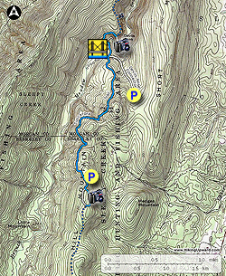
Devils Nose - 2.2 Miles

  • Mile 0.0 - From the parking area at the end of Maverick Trail road, pass through the closed gate onto the white blazed Devils Nose Connector Trail. The trail is wide and easy to navigate. Pass a side trail on the right that leads down to Meadow Branch in 0.4 miles.
  • Mile 0.6 - Turn right off the Devils Nose Connector Trail onto the narrower blue blazed Tuscarora Trail. The Tuscarora Trail will head down towards Meadow Branch and enter an area of pine trees where it makes a sharp left. Continue downward to Meadow Branch.
  • Mile 0.8 - Cross Meadow Branch over the bridge and stay right beginning to climb Sleepy Creek Mountain. Soon pass a small overlook of Meadow Branch, where the trail turns more steeply uphill. Follow the trail for another 0.25 miles to the intersection of the white blazed Devils Nose Overlook Trail.
  • Mile 1.1 - Follow the white blazed trail onto Devils Nose for outstanding views of Meadow Branch in the gorge below. Note: If you wish to add some additional milage, after stopping at Devils Nose, continue on the Tuscarora Trail for less than a mile where there are two more overlooks of the gorge and valley to the north.
  • Mile 2.2 - Retrace your route back the parking area on Maverick Trail road.

Devils Nose/Third Hill Mountain - 6.2 Miles

  • Mile 0.0 - From the parking area at the end of Audubon road, pass through the gate and head south/uphill on the blue blazed Tuscarora Trail that follow a jeep road at this point.
  • Mile 0.1 - Turn left where the Tuscarora Trail leaves the jeep road. The trail will pass three good overlooks to the east before turning right and rejoining the jeep road.
  • Mile 0.35 - Turn right/north and follow the jeep road and back toward the parking area.
  • Mile 0.6 - Just before the gate and parking area, turn left staying on the the blue blazed Tuscarora trail. The trail will now pass through three main gullies and several small ones before arriving at the intersection with the Devils Nose Connector Trail in 2.0 miles.
  • Mile 2.6 - Cross the Devils Nose Connector Trail remaining on the Tuscarora Trail. The Tuscarora Trail will head down towards Meadow Branch and enter an area of pine trees where the trail makes a sharp left. Continue downward to Meadow Branch.
  • Mile 2.8 - Cross Meadow Branch over the bridge and stay right beginning to climb Sleepy Creek Mountain. Soon pass a small overlook of Meadow Branch where the trail turns more steeply uphill. Follow the trail for another 0.2 miles to the intersection of the white blazed Devils Nose Overlook Trail.
  • Mile 3.1 - Follow the white blazed trail onto Devils Nose for outstanding views of Meadow Branch in the gorge below. Note: If you wish to add some additional milage, after stopping at Devils Nose, continue on the Tuscarora Trail for less than a mile where there are two more overlooks of the gorge and valley to the north.
  • Mile 5.5 - Retrace your route back the parking area on Audubon road to end the hike.
Explore 16 trails near Hedgesville, WV
  1. Parking

    39.586819, -78.119004
  2. Main Trailhead

    39.586938, -78.118887
No community routes found. To add your own hike as a Community Route for this Trail guide, leave a Trip Report with an attached GPX file.

Hazards

Ticks - Lyme Disease More Info (CDC)
Snakes
Poison Ivy/Oak

Seasons

All

Blaze Color

Blue

Trip Reports

Trail Guide By:
HikingUpward user profile picture
5.4 miles / 8.7 km

Weather Forecast

In Hedgesville, WV

Explore Hiking Trails

You May Also Like

Colorado's Million Dollar Highway - Plan a day's drive adventure along the iconic Million Dollar Highway in Colorado. Explore the best short trails, roadside stops, waterfalls, vistas, ghost towns, and hot springs within a ~6 hour road trip.
Explore

Colorado's Million Dollar Highway

Plan a day's drive adventure along the iconic Million Dollar Highway in Colorado. Explore the best short trails, roadside stops, waterfalls, vistas, ghost towns, and hot springs within a ~6 hour road trip.

Read
New York's Best Waterfalls - Whether you're planning a day hike, roadside stop, or a leisurely short walk, this guide provides hikers, travelers, and locals alike with 63 different locations to over 100 scenic waterfalls to help plan your next adventure!
Explore

New York's Best Waterfalls

Whether you're planning a day hike, roadside stop, or a leisurely short walk, this guide provides hikers, travelers, and locals alike with 63 different locations to over 100 scenic waterfalls to help plan your next adventure!

Read

Before you boogie...

Find our trail guides useful? Consider becoming a Supporter to unlock perks!

MyHikes is an indie platform that makes exploring public trails easier for everyone. The platform has no investors, no ads, and is owned and operated by one person, Dave Miller. Dave has personally mapped and written over 1,800 trail guides on MyHikes for the public to explore. MyHikes has helped millions outdoor enthusiasts plan their next adventure.

But it takes a lot of time 🕦, money 💰, work, and espresso shots ☕ to run MyHikes, including hiking , mapping , writing , and publishing new trails with high-quality (accurate) information... along with software engineering (coding) the platform like building new features, website and mobile app development (iOS and Android), site maintainance . and much much more.

Supporters unlock website and mobile app perks with an annual one-time payment of $25 (you renew) 😎👍. Or you can simply make a Donation of your choice. Otherwise, you can support us by telling your friends about MyHikes - both quick and free 🎉

Admin user profile picture

Dave Miller
MyHikes Founder