Loading...

Distance:
6.5 Miles / 10.5 km
Type:
Out-and-Back
Difficulty:
Hard
Time to Hike:
3 hours, ~15 minutes
Features:
Surface Type:
Dirt
Park:
Deschutes National Forest
Town:
Sisters, Oregon
Directions:
44.260415, -121.810012
Added:
September 12, 2017
Updated:
January 25, 2021

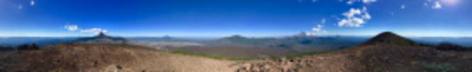
The Belknap Crater Trail at Deschutes National Forest near Sisters, Oregon is a difficult hike up to the sandy summit of Belknap Crater, a cinder cone surrounded by the great expanses of the Belknap Lava Bed, and features stunning views.

The hike is marked difficult due to course, rough lava, and steep and sandy grades.

The last part of the hike, past the lava flow, is extremely sandy, slippery, and steep! Your progress will be slow, but it never gets too sketchy. The path is for the most part, easy to follow. The trail leading away from the Pacific Crest Trail is not marked. It is seen to your left immediately after you exit the lava bed (beyond the Little Belknap Crater Trail junction).

Explore 3 trails near Sisters, OR
  1. Parking

    44.260415, -121.810012
  2. Main Trailhead

    44.260368, -121.809578
  3. Panoramic vista from the summit of Belknap Crater

    44.285667, -121.841431
    Panoramic vista from the summit of Belknap Crater
Explore other trail routes for this hike, added by the MyHikes Community via Trip Reports.
No community routes found. To add your own route as a Community Route for this Trail guide, please leave a Trip Report with a GPX file on this Trail.

Hazards

Rockfalls / Ledges / or Scrambles

Seasons

Summer, Fall
Loading...
Loading...
1,649 '

Total Change
1,739 '

Ascent
1,663 '

Descent

Photo Albums

1 Trip Report

No Star-Ratings
6.5 miles / 10.5 km
Trail added
September 12, 2017
Hiked on
July 22, 2017
Updated on
January 25, 2021

Weather Forecast

In Sisters, OR

Explore Hiking Trails

New Hikes

Almond Lake Overlook
0.1 Miles
0.2 km
Easy
Out-and-Back
Coquina Loop (Old Levi Mill Waterfall)
1.7 Miles
2.7 km
Moderate
Loop
Double Run to Canyon Vista Loop
3.7 Miles
6 km
Moderate
Loop
Fred's Bog Trail
0.7 Miles
1.1 km
Easy
Out-and-Back

Before you leave...

MyHikes is an indie web platform aimed to make exploring public trails easier for everyone. The site has no investors and is owned and operated by one person, Dave Miller (Founder & Admin). As the Founder, main contributor, and doer-of-all-things for MyHikes, I share my trips with over-detailed write-ups for fun on a volunteer basis and I believe that public trail information should be available to everyone.

It takes a lot of time 🕦, money 💰, and effort (including espresso shots ☕) to run MyHikes, including hiking , mapping , writing , and publishing new trails with high-quality content... along with building new features, moderating, site maintainance, and app development for iOS and Android . I simply ask that if you find MyHikes' trail guides helpful to please consider becoming a Supporter to help keep the site, iOS, and Android apps available to everyone.

Supporters unlock website and in-app perks with a one-time payment of $25 (you renew) 😎👍. Or you can simply make a Donation of your choice without a MyHikes user account. Otherwise, telling your friends about MyHikes is the next-best thing - both quick and free 🎉

Thanks for visiting MyHikes and have a great hike!️

Admin user profile picture

Dave Miller
MyHikes Founder & Admin