Loading...

WINTER SALE! 50% OFF Supporter Accounts — now through January 31st. Learn More.

Dead Run Hike

Dead Run, just west of Turkey Run Park, is arguably one of the prettiest streams with small waterfalls inside the D.C. Beltway. A short 3.8 mile loop along the Potomac Heritage Trail and Dead Run, this hike is a great walk in the woods if you don't have much time to get out.

In springtime Dead Run is at its peak with several small pools and waterfalls as it flows for the last 1/4 mile into the Potomac River. The Potomac Heritage Trail is also in bloom this time of year with Virginia Blue Bells.

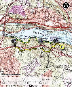
  • Mile 0.0 – From the C1 Turkey Run parking area, head downhill towards the Potomac Heritage Trail on the yellow blazed trail shortly passing an intersection on your left. Stay straight, the trail becomes steep in 100 yards making several sharp switchbacks, then ends at the Potomac River and intersection of the Potomac Heritage Trail.
  • Mile 0.2 – Turn left upstream on the yellow and green blazed Potomac Heritage Trail for 0.1 miles.
  • Mile 0.3 - Cross Turkey Run and stay right on the green and yellow blazed Potomac Heritage Trail (PHT) as it follows the Potomac River. In the spring this section of the Potomac river is awash in Virginia Blue Bells (Mertensia virginica). The PHT winds along the banks of the Potomac River crossing several small streams before reaching the much larger Dead Run.
  • Mile 1.7 - The PHT crosses Dead Run at this point. Do Not cross Dead Run, but follow the yellow blazed trail along the left bank for 30 yards where it crosses over to the right bank. The yellow blazed trail is not very apparent as this section has been washed out in the last couple of years. Pass several small pools and waterfalls which are the highlight of the hike. In the summer these make great swimming holes as the water is much warmer than the colder mountain fed streams.
  • Mile 1.8 - Pass under the George Washington Parkway then immediately cross Dead Run back to the left bank. This area is part of Langley Oaks Park and has many interconnecting unmarked trails. Follow the yellow blazed trail markings and you shouldn't get lost. Pass a flatter area and small trail on the right. After passing the first trail reach the next intersection at a small rise. Stay right and pass along a fence marking private property in the Langley Oaks sub-division. Descend through another steep gully and rise to the next intersection. Turn right for 100 yards, then turn left downhill to the next intersection and arrive at Turkey Run.
  • Mile 3.1 - Turn left downstream on Turkey Run, then where Turkey Run passes under the George Washington Parkway cross Turkey Run, then in 25 yards take the trail right uphill.
  • Mile 3.3 - Follow the yellow blazed trail uphill and back over to the first intersection you passed at the beginning of the hike.
  • Mile 3.5 - Turn right uphill for the remaining 0.1 miles to the parking area
  • Mile 3.6 - Return to the Turkey Run C1 parking area.
Explore 19 trails near McLean, VA

Know Before You Go

  • Dead Run Trail in McLean, VA, offers a scenic 3.6-mile loop featuring waterfalls and streams, particularly beautiful in springtime.
  • The hike includes sections along the Potomac Heritage Trail, known for its Virginia Blue Bells in the spring, and follows Dead Run upstream, with potential swimming holes in the summer.
  • Navigating the trail requires attention to yellow blazes, especially around Dead Run and Langley Oaks Park due to washed-out sections and unmarked intersecting trails.
Interactive topographic map for Dead Run Hike located in McLean, VA. Click the "View Map" button to load GPS coordinates and trail markers.
Get directions
Distance
3.1 mi
Difficulty
Easy
Type
Loop
Est. Time
1.6 hrs
Elev. Gain
498'
Rating
3.5
Added
April 03, 2025
Updated
April 06, 2025

Weather Forecast

Loading...
Total Change
165'
Ascent
498'
Descent
505'
Loading...

Download the GPX Data for Offline Use

Supporters get exclusive access to download trail routes to the MyHikes app for offline use. Stay prepared on your adventure, even without an internet connection! Become a Supporter today to unlock this feature and hike with confidence.

Download Dead Run Hike GPX Data to the MyHikes Mobile App

Features

Vista / Lookout Point
Dogs
Waterfalls
Water Source

Points of interest

  1. Parking

    38.96436, -77.152936
  2. Main Trailhead

    38.96436, -77.152936

Safety information

For your own safety: plan ahead, let someone know where you'll be, and hike at your own risk.

Hazards

Snakes (Rattlesnakes, Copperheads, others)
Poison Ivy or Poison Oak

Markers

Blaze Color

Yellow

Availability

All seasons

Surface type

Dirt

Trip Reports (Reviews)

Rated 3.5 out of 5 based on 16 ratings.

Ready to help fellow hikers? Add a trip report to share your experience and provide valuable insights for other hikers!

By: JMP
3.1 miles / 5.0 km
January 29, 2017
VERY poorly marked, and maintained, the sections off the river, especially the clear cut power line sections south of GW Parkway near Turkey Run. Does anyone know who maintains this section of the trail. PATC? Are there workdays? Could be a very nice fairly rigorous circuit.
Legacy Review
By: Justin V
3.1 miles / 5.0 km
January 25, 2017
Fine hike considering how close to downtown it is. The portion with the stream is nice, but the rest is pretty plain. Decent hills up and down keep it a little interesting, but for most of it you're just walking through the woods. Def watch out for downed trees - I counted 3 that were basically on the trail, and all required taking 10-15 seconds to be sure which direction to go.
Legacy Review
By: Mel
3.1 miles / 5.0 km
January 15, 2017
This was a robust hike that is close enough to DC to be undertaken last minute, but remote enough to make you feel like you are farther out from the city. Parts of this hike that require rock scrambling and ravine crossing are more 3 than 2, but overall, the trail has a little bit of everything. We started the hike at 8:30am and no on else was there yet. Finished it in 3 hours, but we also walked at a slower pace. There wasn't much birdwatching to be had, but we did see a beautiful Pileated Woodpecker! Strongly suggest hiking footwear and not running shoes.
Legacy Review
No community routes found. To add your own hike as a Community Route for this Trail guide, leave a Trip Report with an attached GPX file.

Popular categories

Scenic mountain view representing vista trails
Vista trails
Scenic gorge of cascades representing waterfall trails
Waterfall hikes
Rugged mountain terrain representing summit trails
Summit trails
Scenic mountain view representing dog-friendly trails
Dog-friendly
Scenic campsite with a view representing camping trails
Camping trails
Appalachian Trail logo representing A.T. hikes
A.T. hikes

You May Also Like

25 Best Day Hikes in North Carolina - Discover the top 25 best day hikes in North Carolina, from breathtaking waterfalls to mountain peaks. Explore hidden gems, scenic views, and trails suitable for all skill levels, perfect for your next outdoor adventure.
Explore

25 Best Day Hikes in North Carolina

Discover the top 25 best day hikes in North Carolina, from breathtaking waterfalls to mountain peaks. Explore hidden gems, scenic views, and trails suitable for all skill levels, perfect for your next outdoor adventure.

Read
🍪 We use cookies to learn about site usage and to serve map tiles. You may block cookies manually in the browser. By continuing you agree. Learn more