Loading...

WINTER SALE! 50% OFF Supporter Accounts — now through January 31st. Learn More.

Cumberland Knob Hike

Cumberland Knob Recreation Area is not noteworthy for being a hiking destination. However, it does have a great loop trail that likely attracts few hikers due to its short length and remote location. This loop is short and will take less than 2 hours maximum, so it is not something to plan a full day around. But, if you are exploring the Blue Ridge Parkway near the North Carolina/Virginia border this could be a great stop to stretch your legs or combine it with other short trails along the parkway.

The Gully Creek Trail leaves the picnic area and drops steeply to the Gully Creek drainage where you will follow the creek for a fantastic half mile. Here you will pass a small, beautiful waterfall and numerous cascades in this narrow gorge. After leaving the creek the trail climbs steadily to the tree-covered Cumberland Knob before returning to the picnic area. Be sure to check out the eastern view of Pilot Mountain from the grassy picnic area before you hop back in the car.

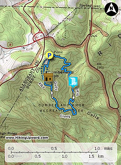
Where NC-18 crosses under the Blue Ridge Parkway at Low Gap a few miles south of the Virginia border, enter the parkway and drive south for 0.3-mi. The Cumberland Knob Recreation Area is well-signed on the east side of the highway with ample parking for cars and campers. Park in the main lot beside the picnic area and comfort station. The loop trail starts directly behind the comfort station on the left side of the parking lots.

  • Mile 0.0 – Start the Gully Creek Trail (no blaze) behind the comfort station. Go left towards picnic area into the forest. The trail starts downhill on a wide dirt path.
  • Mile 0.5 – The trail meets a tributary and begins a steep descent on tight switchbacks towards Gully Creek. The trail frequently touches but doesn’t cross the tributary.
  • Mile 0.75 – End of descent as the trail meets Gully Creek above a waterfall.
  • Mile 0.8 – 1st crossing over Gully Creek below a picturesque 6-foot waterfall. No knowledge if this is a named waterfall. The trail crosses Gully Creek 9 times in the next 0.5 miles.
  • Mile 0.85 – 2nd crossing.
  • Mile 0.9 – 3rd crossing on a bridge.
  • Mile 1.0 – 4th crossing between a cascade amongst large boulders and above a slide waterfal.
  • Mile 1.1 - 5th crossing and 6th crossing.
  • Mile 1.15 – 7th crossing onto an island that divides Gully Creek. The trail follows this island downstream.
  • Mile 1.2 – 8th crossing. There’s a nice cascade with mossy boulders in the creek below the crossing.
  • Mile 1.25 – 9th crossing. The trail leaves Gully Creek and climbs steeply up the west side of the basin. The trail climbs 855 feet in 1.1 miles to Cumberland Knob.
  • Mile 1.6 – The trail follows a shoulder rising high above Gully Creek. The vegetation here is reminiscent of much higher elevations and there are intermittent views into the creek basin and of the mountain peaks across the basin.
  • Mile 2.2 – Junction with Cumberland Knob Trail, go left to the summit. The Gully Creek Trail stays right returning to the picnic area.
  • Mile 2.4 – Reach summit of Cumberland Knob (2,885 feet). The summit is a small grass field surrounded by forest with no views. There is an old stone shelter at the summit. Two parallel trails leave the summit heading back to the parking lot. The left trail is paved and goes through the picnic area. Go right of the shelter slightly downhill to rejoin the Gully Creek Trail.
  • Mile 2.6 – Junction with Gully Creek Trail at the beginning of the large grass field at the picnic area. Go left to return to the trail head. There is one view due east through the trees with Pilot Mountain standing tall in the background.
  • Mile 2.8 – Loop ends at the comfort station behind the parking lot.
Bonus: A few miles south of Cumberland Knob is the excellent Fox Hunter’s Paradise Overlook on High Piney Spur (2,805 feet). In addition to the view on the roadside turnout there is a side loop road to the right that leads to a short walk to a stone overlook. This stone overlook is perched at the end of High Piney Spur and provides great views south of Saddle Mountain and east and north of the ridge crest that dramatically drops to The Piedmont. Pilot Mountain can be spotted many miles away due east. A large tree provides shade so this makes an enjoyable stop for a snack break to admire one of the best overlooks in this region.
By HikingUpward Contributor: Zach Robbins
Explore 5 trails near Lowgap, NC

Know Before You Go

  • The Cumberland Knob/Gully Creek Loop is a short, 2.2-mile hike located in a remote area of the Blue Ridge Parkway near the NC/VA border, ideal for a leg stretch or as part of a larger parkway exploration.
  • The Gully Creek section of the trail features a steep descent to a creek with multiple crossings, a small waterfall, and cascades within a narrow gorge, offering a scenic and engaging hiking experience.
  • While the summit of Cumberland Knob itself lacks significant views, the picnic area offers an eastern view of Pilot Mountain, and the nearby Fox Hunter's Paradise Overlook provides exceptional views of Saddle Mountain and the surrounding Piedmont region.
Interactive topographic map for Cumberland Knob Hike located in Lowgap, NC. Click the "View Map" button to load GPS coordinates and trail markers.
Get directions
Distance
2.2 mi
Difficulty
Moderate
Type
Loop
Est. Time
1.1 hrs
Elev. Gain
945'
Rating
0.0
Added
March 22, 2025
Updated
April 06, 2025

Weather Forecast

Loading...
Total Change
878'
Ascent
945'
Descent
945'
Loading...

Download the GPX Data for Offline Use

Supporters get exclusive access to download trail routes to the MyHikes app for offline use. Stay prepared on your adventure, even without an internet connection! Become a Supporter today to unlock this feature and hike with confidence.

Download Cumberland Knob Hike GPX Data to the MyHikes Mobile App

Features

Vista / Lookout Point
Dogs
Waterfalls
Mountain Summit
Water Source

Points of interest

  1. Parking

    36.553767, -80.906973
  2. Main Trailhead

    36.553948, -80.906861

Safety information

For your own safety: plan ahead, let someone know where you'll be, and hike at your own risk.

Hazards

Snakes (Rattlesnakes, Copperheads, others)
Poison Ivy or Poison Oak

Availability

All seasons

Surface type

Dirt

Trip Reports (Reviews)

Your opinion matters! Be the first to rate this trail.

Ready to help fellow hikers? Add a trip report to share your experience and provide valuable insights for other hikers!

No community routes found. To add your own hike as a Community Route for this Trail guide, leave a Trip Report with an attached GPX file.

Popular categories

Scenic mountain view representing vista trails
Vista trails
Scenic gorge of cascades representing waterfall trails
Waterfall hikes
Rugged mountain terrain representing summit trails
Summit trails
Scenic mountain view representing dog-friendly trails
Dog-friendly
Scenic campsite with a view representing camping trails
Camping trails
Appalachian Trail logo representing A.T. hikes
A.T. hikes

You May Also Like

25 Best Day Hikes in North Carolina - Discover the top 25 best day hikes in North Carolina, from breathtaking waterfalls to mountain peaks. Explore hidden gems, scenic views, and trails suitable for all skill levels, perfect for your next outdoor adventure.
Explore

25 Best Day Hikes in North Carolina

Discover the top 25 best day hikes in North Carolina, from breathtaking waterfalls to mountain peaks. Explore hidden gems, scenic views, and trails suitable for all skill levels, perfect for your next outdoor adventure.

Read
Colorado's Million Dollar Highway - Plan a day's drive adventure along the iconic Million Dollar Highway in Colorado. Explore the best short trails, roadside stops, waterfalls, vistas, ghost towns, and hot springs within a ~6 hour road trip.
Explore

Colorado's Million Dollar Highway

Plan a day's drive adventure along the iconic Million Dollar Highway in Colorado. Explore the best short trails, roadside stops, waterfalls, vistas, ghost towns, and hot springs within a ~6 hour road trip.

Read
Glacier's Going-to-the-Sun Road - Discover the breathtaking beauty of Glacier National Park along the iconic Going-to-the-Sun Road. From stunning roadside stops to picturesque waterfalls and vistas, this engineering marvel offers endless opportunities for exploration.
Explore

Glacier's Going-to-the-Sun Road

Discover the breathtaking beauty of Glacier National Park along the iconic Going-to-the-Sun Road. From stunning roadside stops to picturesque waterfalls and vistas, this engineering marvel offers endless opportunities for exploration.

Read
🍪 We use cookies to learn about site usage and to serve map tiles. You may block cookies manually in the browser. By continuing you agree. Learn more