Loading...

🎉 Enjoy a Free 7-Day Supporter Trial and Unlock Exclusive Perks — No Credit Card Required. Learn more.

Cranesville Swamp Loop Trail

Directions
Map
Pictures
Send to App
Distance:
0.4 Miles / 0.6 km
Type:
Loop
Difficulty:
Easy
Time to Hike:
~12 minutes
Features:
Surface Type:
Boardwalk
Park:
Cranesville Swamp Natural Area
Town:
Terra Alta, West Virginia
Directions:
39.531849, -79.485613
Added:
April 14, 2018
Updated:
January 23, 2020
Copy Trail Link Hiking this trail? Send a friend or family member a link to this trail guide for your own safety. Hike at your own risk (disclaimer)
Loading...
Loading...
27'

Total Change
6'

Ascent
29'

Descent

Download the Trail Route for Offline Use

Supporters get exclusive access to download trail routes to the MyHikes app for offline use. Stay prepared on your adventure, even without an internet connection! Become a Supporter today to unlock this feature and hike with confidence.

Send to App

Cranesville Swamp Loop Trail

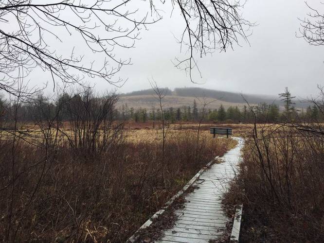
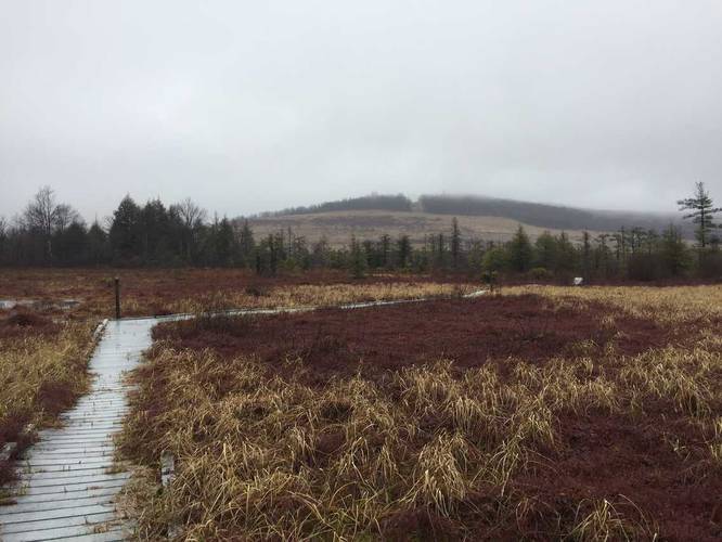
The Loop Trail at the Cranesville Swamp Natural Area in Terra Alta, West Virginia is an easy 0.4 mile hike that leads into the wetlands of the park with awesome views surrounding you. This is likely one of the best trails in the park since the trail lies within a large valley, so you get views of the hills around you, but you also get a variety of plant life too.

The trail is fairly unique in that half of it is a boardwalk that runs above the wetland and half runs along the dirt outside of the wetland area. Back on the dirt portion of the trail, you'll pass through a grove of coniferous trees before heading back into the deciduous forest.

In order to get to this trail you need to hike in on the Blue Trail, Orange Trail, or White Trail (not mapped on MyHikes yet).

Note mud and water conditions: Since the trail passes through wetlands, it can be muddy in certain areas. Some areas of the boardwalk can be flooded after it rains too - which is usually an inch or to of water. You can get by the flooding with proper footwear or you can walk along the edge of the boardwalk which usually sits flush with the waterline during high water.

Dogs are allowed on this trail.
Explore 22 trails near Terra Alta, WV
  1. Parking

    39.531849, -79.485613
  2. Main Trailhead

    39.534888, -79.483392
  3. Trailhead with view of the swamp and neighboring hills

    39.534931, -79.483375
    Trailhead with view of the swamp and neighboring hills
  4. View of the swamp and neighboring hills

    39.534919, -79.483047
    View of the swamp and neighboring hills
No community routes found. To add your own hike as a Community Route for this Trail guide, leave a Trip Report with an attached GPX file.

Hazards

Ticks - Lyme Disease More Info (CDC)

Seasons

All

Photo Albums

Trip Reports

Trail Guide By:
Admin user profile picture
0.4 miles / 0.6 km
0.4 miles / 0.6 km
March 30, 2018
Hiking

Weather Forecast

In Terra Alta, WV

Explore Hiking Trails

You May Also Like

Colorado's Million Dollar Highway - Plan a day's drive adventure along the iconic Million Dollar Highway in Colorado. Explore the best short trails, roadside stops, waterfalls, vistas, ghost towns, and hot springs within a ~6 hour road trip.
Explore

Colorado's Million Dollar Highway

Plan a day's drive adventure along the iconic Million Dollar Highway in Colorado. Explore the best short trails, roadside stops, waterfalls, vistas, ghost towns, and hot springs within a ~6 hour road trip.

Read
New York's Best Waterfalls - Whether you're planning a day hike, roadside stop, or a leisurely short walk, this guide provides hikers, travelers, and locals alike with 63 different locations to over 100 scenic waterfalls to help plan your next adventure!
Explore

New York's Best Waterfalls

Whether you're planning a day hike, roadside stop, or a leisurely short walk, this guide provides hikers, travelers, and locals alike with 63 different locations to over 100 scenic waterfalls to help plan your next adventure!

Read

Before you boogie...

Find our trail guides useful? Consider becoming a Supporter to unlock perks!

MyHikes is an indie platform that makes exploring public trails easier for everyone. The platform has no investors, no ads, and is owned and operated by one person, Dave Miller. Dave has personally mapped and written over 1,800 trail guides on MyHikes for the public to explore. MyHikes has helped millions outdoor enthusiasts plan their next adventure.

But it takes a lot of time 🕦, money 💰, work, and espresso shots ☕ to run MyHikes, including hiking , mapping , writing , and publishing new trails with high-quality (accurate) information... along with software engineering (coding) the platform like building new features, website and mobile app development (iOS and Android), site maintainance . and much much more.

Supporters unlock website and mobile app perks with an annual one-time payment of $25 (you renew) 😎👍. Or you can simply make a Donation of your choice. Otherwise, you can support us by telling your friends about MyHikes - both quick and free 🎉

Admin user profile picture

Dave Miller
MyHikes Founder