Loading...

🍁 Fall is here! Check out our foliage map to plan your autumn hikes! Learn more.

Cove Mountain Hike

Directions
Map
Pictures
Send to App
Distance:
7.1 Miles / 11.4 km
Type:
Loop
Difficulty:
Moderate
Time to Hike:
3 hours, ~33 minutes
Features:
Appalachian Trail hike
Surface Type:
Dirt
Park:
Jefferson National Forest
Town:
Buchanan, Virginia
Get Directions:
37.521234, -79.624325
Added:
February 28, 2025
Updated:
April 05, 2025
Guide by:
Copy Trail Link Hiking this trail? Send a friend or family member a link to this trail guide for your own safety. Hike at your own risk (disclaimer)
Loading...
Loading...
1,545'

Total Change
1,888'

Ascent
1,888'

Descent

Download the Trail Route for Offline Use

Supporters get exclusive access to download trail routes to the MyHikes app for offline use. Stay prepared on your adventure, even without an internet connection! Become a Supporter today to unlock this feature and hike with confidence.

Send to App

Key Takeaways

  • This 7.5-mile loop hike near Buchanan, VA offers diverse scenery, including views, a cove, the Appalachian Trail, a climb, and waterfalls.
  • The trail guide provides instructions for a "local insider" route to avoid a road walk and see an additional waterfall, but it includes sections of unmaintained trail that require navigation skills and a GPS.
  • The hike incorporates sections of the Appalachian Trail and Little Cove Mountain Trail, with options for a shorter, less strenuous loop using the Glenwood Horse Trail.

Cove Mountain Hike

Only 10 minutes from the interstate, this loop packs a little bit of everything into only 7.5 miles: great views, a beautiful cove, the Appalachian Trail, a stiff climb, and even a waterfall! Most hikers doing this hike involving the two major trails loop back via a 15 minute road walk. This “local insider” version shows you how to avoid the road walk for more wooded bliss with a bonus waterfall which most hikers miss!

Note: This hike uses sections of non-maintained/non-blazed trail. Appropriate navigation skills and a GPS with the provided hike route are recommended.

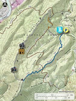
The trailhead is accessed by exiting Interstate 81 at the Arcadia exit and heading east over the James River and into the Jefferson National Forest on Jennings Creek Road. Pass signs first for the Forest Service’s North Creek Campground and then the Middle Creek Picnic Area, and look for a brown hiker sign and pedestrian bridge on the right. Park off the side of the road when you see these.

  • Mile 0.0 – The trailhead is a wooden pedestrian bridge over Jennings Creek at an elevation of just over 1000 feet. You are briefly hiking on the blue blazed Little Cove Mountain Trail, which will be your return trail. Just on the other side of the bridge is a campsite. This campsite was once the site of an Appalachian Trail shelter, as your first 100 yards of this hike is an old part of the Appalachian Trail. Back in the late 1970’s or early 1980’s, The A.T. was rerouted about a mile further west to avoid hikers walking along Jennings Creek Road. The old A.T. trail bed heads uphill almost invisibly to your right a little further down the trail, but that section of trail is no longer maintained.
  • Mile 0.1 – The trail splits here. Go uphill to the right onto an unblazed trail, as shown in the photo. You will return on the trail to the left. This direction is recommended as the trail is easier to follow this way.
  • Mile 0.3 – Look for rocks on your left, and head down for a view of a beautiful waterfall of Cove Creek immediately below the rocks.
  • Mile 0.4 – Cross a small stream (your last water until the end of this hike), then pass the first of three old woods roads you will encounter on this portion of your hike. In each case, take the uphill route, which should be obvious as the trail is more worn in the correct option. The first two times, you will go to the right, and the third time will be to the left; always the uphill option.
  • Mile 0.8 – The trail ends at a “T” intersection when you reach a wide woods road that is the Glenwood Horse Trail (blazed orange). You will turn right here. (Turning left on the Glenwood Horse Trail takes you in 3.1 miles to the Little Cove Mountain Trail, which you can take left back to your vehicle for a less strenuous and less interesting 6.3 mile loop hike.) If you are taking this loop clockwise and returning to your vehicle from here, there is an old style trail marker which designates the trail – silver paint and some ax choppings to a tree – found a few feet to the left of the Glenwood Horse Trail and just to the right of the unmarked trail. There is no trail sign.
  • Mile 1.0 – The Glenwood Horse Trail narrows dramatically here and becomes an actual trail rather than a grassy woods road. Starting here, the trail follows an old Appalachian Trail alignment to the current A.T. If your eyes are really sharp and you look both ways over the next half mile, you might even see an old A.T. blaze on a tree trunk that has been painted brown to hide it.
  • Mile 1.5 – After clinging to the sides of steep slopes for half a mile, the Glenwood Horse Trail intersects with the Appalachian Trail. The intersection is marked by signs prohibiting bicycles on the A.T. and by decaying fencing to keep horses off the A.T., but there is no intersection trail sign. Look for the white A.T. blazes, and turn left, heading uphill. (To the right, the A.T. heads downhill 1 mile to the Jennings Creek Road, about a 15 minute walk west of your vehicle. The Glenwood Horse Trail continues straight ahead, heading towards the town of Arcadia.)
  • Mile 1.8 – After climbing somewhat steeply, the Appalachian Trail intersects with the Buchanan Trail. Stay left on the white blazed A.T.
  • Mile 3.3 – Shortly after passing a small campsite on your right, the trail encounters some rocks with a nice view to the southwest.
  • Mile 3.5 – A side trail drops down to the A.T. Cove Mountain Shelter. The shelter has a new privy, a new picnic table and a new roof, but the shelter itself was taken apart from its original location at Marble Springs in the James River Face Wilderness, and reconstructed here back in the early 1980’s. This is a nice place to stop for a snack, but this shelter has no water source nearby.
  • Mile 4.1 – Pass through an area with multiple nice views to the west of the town of Buchanan, Purgatory Mountain, and the James River.
  • Mile 4.6 – Nice views down into the Cove Creek valley, courtesy a July, 2008 forest fire in this area. You will note that the forest is coming back, as the area is now covered in Virginia Pine that will obscure this view in the next few years.
  • Mile 4.8 – The A.T. intersects with the Little Cove Mountain Trail at the high point of the hike, 2575 feet. Turn left here onto a blue blazed trail, and begin descending to your vehicle. (The A.T. continues here southbound for two miles to Virginia Route 43, near Bearwallow Gap and the Blue Ridge Parkway, a few miles south of the Parkway’s Peaks of Otter resort.)
  • Mile 5.7 – Trail crosses gravel road that is part of the Glenwood Horse Trail. Be sure to check out the old, beat up Forest Service informational sign justifying nearby clear cuts to the forest. The gated road on the far left connects to early parts of this loop. You will continue on the Little Cove Mountain Trail, found to the right as you descend to the road. Look for the blue blazes.
  • Mile 6.4 – A woods road crosses the trail. Continue straight.
  • Mile 7.0 – The trail merges onto an old woods road as the trail descends into a lush valley formed by Little Cove Creek.
  • Mile 7.2 – The trail crosses Little Cove Creek, and shortly afterwards crosses Cove Creek before passing a campsite and merging with the trail taken at the beginning of this hike.
  • Mile 7.5 – Return back to Jennings Creek Road and your vehicle.
By HikingUpward Contributor: Jeff Monroe
Explore 27 trails near Buchanan, VA
  1. Parking

    37.521234, -79.624325
  2. Main Trailhead

    37.521234, -79.624325
No community routes found. To add your own hike as a Community Route for this Trail guide, leave a Trip Report with an attached GPX file.

Hazards

Ticks - Lyme Disease More Info (CDC)
Snakes
Poison Ivy/Oak

Seasons

All

Blaze Color

White

Photo Albums

+ Add Photo Album

Upload your photos from the trail to help others know what to expect.

Preview of the MyHikes mobile app interface

Track, Log, and Explore Hikes with the MyHikes App

Explore Autumn Foliage

No Change
Some Color
Low Color
Moderate Color
High Color
Peak Color
Past Peak
Sept 1 Sept 8 Sept 15 Sept 22 Sept 29 Oct 6 Oct 13 Oct 20 Oct 27 Nov 3 Nov 10 Nov 17 Nov 24

Trip Reports (Reviews)

Ready to help fellow hikers? Add a trip report to share your experience and provide valuable insights for those planning their next hike. Your review makes the trail better for everyone.

Rated 3.75 out of 5 based on 8 ratings.
By: John
7.1 miles / 11.4 km
September 07, 2019
I hiked this counterclockwise. As previous reviewers have said, the conditions on non AT portions are still pretty good. Also as previous reviewer said, plenty of spiderwebs. I also found many micro/tiny bugs (maybe ticks, couldn't tell as they were very small) crawling on my the rest of the night. This was after I took a shower and then took a bath. The hike was very dry when I did it in late summer, Little Cove Creek was not running and Jennings Creek was very very low. My intent was to see sunset on the ridge, the outcrop just north of the AT shelter would have been perfect for sunset. I got there a bit too early so I continued on and ended up passing all the good vistas to the west by the time I reached the Little Cove Mountain junction. I ended exploring the AT SOBO all the way till the Cove Mountain Peak and it was all just a green tunnel. Full trip report here: https://travel2walk.com/2019/09/13/virginia-hikes-cove-mountain-loop-september-7-2019/
Legacy Review
By: Patrick
7.1 miles / 11.4 km
August 10, 2019
It was a great hike on a good day with great weather in the mountains. We only encountered two other people on the hike. There were a couple of things that we did notice during the hike. This hike will be an amazing hike in the fall and winter if seeking solitude from the crowds going to Shenandoah. 1. The trails, especially the unblazed trail and the Glenwood Horse Trail are in very good shape. Somebody has been doing an amazing job of maintaining those trails. They are in really good shape. Thank you to the maintainer, who is keeping these trails in really good shape. 2. There is a yellow jacket nest on the Little Cove Mountain about a mile from the end of the hike. A couple of people in our group got stung. Please be careful out there if you decide to do this hike. I am definitely going to do this hike in the winter for the winter time views, which are going to be awesome when the leaves are off the trail.
Legacy Review
By: Wrong Pocket
7.1 miles / 11.4 km
April 28, 2019
My 9 year old son and I hiked this trail backwards from directions. Clockwise, due to my knees don’t like descending steeper hills which is on the return trip as listed. I probably would have been ok to do it either way, but if you do it backwards or clockwise you will definitely climb the steeper sections first, probably a solid 2.7 miles. Then you reach the AT and turn right and then it’s just a nice steady decline the rest of the trip back. We stopped a little more than halfway up near Glenwood Horse Trail for lunch, then again when we got to the cove mountain shelter to hang our hammocks and rest a for about an hour. Whole trip took us about 6 hours. Very nice waterfalls near end of hike, or beginning if you go listed way. Also a few nice views along the ridge, which would definitely be nicer when foliage is off trees in fall or early spring. Never saw the first hiker. Plan on going back and camping somewhere, maybe near the shelter to make a nice little 2 day trip. Would like to see if the following the trail listed on route then turning left on the Glenwood Horse Trail and following it until you get to the cove mountain trail would avoid more of the steep sections. And if there may be water somewhere through that section, which would be nice to refill and cut some weight. If I try it I will repost my findings. As stated only water is at beginning of trail, so camel up before you begin. I packed 2 liters for each of us which was fine. Overall nice little trail, some of everything. My son enjoyed it and had fun in Jennings Creek near the parking area when we finished. Directions were also very good. Thanks!
Legacy Review

Weather Forecast

In Buchanan, VA

Explore Hiking Trails

You May Also Like

New York's Best Waterfalls - Whether you're planning a day hike, roadside stop, or a leisurely short walk, this guide provides hikers, travelers, and locals alike with 63 different locations to over 100 scenic waterfalls to help plan your next adventure!
Explore

New York's Best Waterfalls

Whether you're planning a day hike, roadside stop, or a leisurely short walk, this guide provides hikers, travelers, and locals alike with 63 different locations to over 100 scenic waterfalls to help plan your next adventure!

Read
25 Best Day Hikes in North Carolina - Discover the top 25 best day hikes in North Carolina, from breathtaking waterfalls to mountain peaks. Explore hidden gems, scenic views, and trails suitable for all skill levels, perfect for your next outdoor adventure.
Explore

25 Best Day Hikes in North Carolina

Discover the top 25 best day hikes in North Carolina, from breathtaking waterfalls to mountain peaks. Explore hidden gems, scenic views, and trails suitable for all skill levels, perfect for your next outdoor adventure.

Read

Before you boogie...

Find our trail guides useful? Consider becoming a Supporter to unlock perks!

MyHikes is an indie platform that makes exploring public trails easier for everyone. The platform has no investors, no ads, and is owned and operated by one person, Dave Miller. Dave has personally mapped and written over 1,800 trail guides on MyHikes for the public to explore. MyHikes has helped millions outdoor enthusiasts plan their next adventure.

But it takes a lot of time 🕦, money 💰, work, and espresso shots ☕ to run MyHikes, including hiking , mapping , writing , and publishing new trails with high-quality (accurate) information... along with software engineering (coding) the platform like building new features, website and mobile app development (iOS and Android), site maintainance . and much much more.

Supporters unlock website and mobile app perks with an annual one-time payment of $25 (you renew) 😎👍. Or you can simply make a Donation of your choice. Otherwise, you can support us by telling your friends about MyHikes - both quick and free 🎉

Admin user profile picture

Dave Miller
MyHikes Founder