The Copperas Pond Trail at Adirondack Park within the Sentinel Range Wilderness in Wilmington, New York is a moderate 1.2-mile out-and-back hike that leads to the shores of Copperas Pond and features views of the surrounding mountains.
Hike Description
This hike begins at the main trailhead at the coordinates provided, directly across the street from the parking turnout, and follows a steep and rocky trail as it ascends the base of the Sentinel Mountain Range. The trail climbs at a moderate to steep grade for about 0.3-miles before it begins to undulate uphill toward the pond. Hikers will reach a trail sign, just after mile 0.3, which points the way to Copperas Point - keeping right at the trail junction.
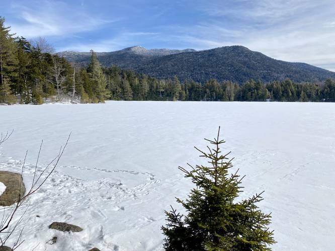
Copperas Pond - Mile 0.5
The trail eventually leads downhill for approximately 0.15-miles and at the bottom of the descent sits Copperas Pond, around mile 0.5. Here, the hiker has a choice of where to walk next; however, if you wish to take in nice views of the surrounding mountains, taking a right-hand turn to head toward the primitive camping leanto leads to nice vistas along the northeastern shore.
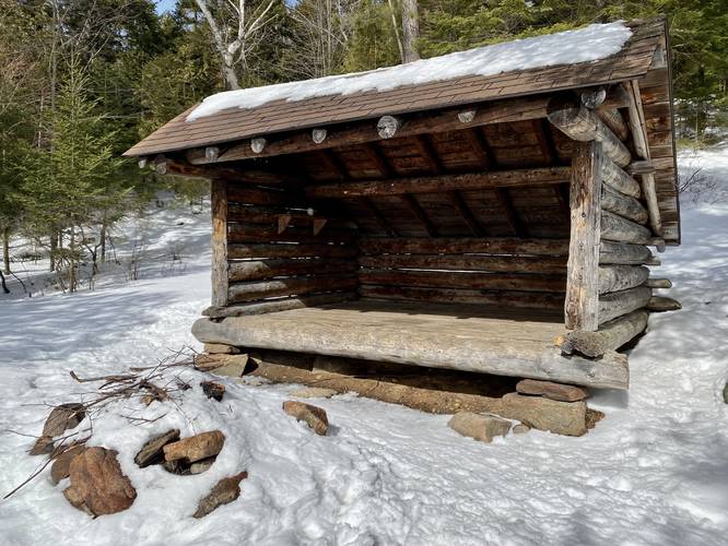
Camping Leanto - Mile 0.6
After taking a right-hand turn when reaching Copperas Pond, hikers can walk another 0.1-miles to reach the primitive camping leanto located on the northeastern shore of the pond. Along the way, hikers get better and better views of Kilburn Mountain (right-most), Sentinel Mountain (center / tallest), and Stewart Mountain (left-most) as they tower over Copperas Pond.
After visiting Copperas Pond, hikers can choose to head back out for a 1.2-mile out-and-back hike or continue further along the trail system here to reach other ponds like Owen Pond.
Parking
Hikers will find a very large parking turn out at the coordinates provided. The turnout is large enough to fit a dozen vehicles or more.
Pets
Dogs are allowed if leashed and if cleaned up after.
Camping and Backpacking
Primitive / dispersed / backcountry camping is allowed at designated leantos and campsites. Please follow all rules and regulations when camping.
Hike Description
This hike begins at the main trailhead at the coordinates provided, directly across the street from the parking turnout, and follows a steep and rocky trail as it ascends the base of the Sentinel Mountain Range. The trail climbs at a moderate to steep grade for about 0.3-miles before it begins to undulate uphill toward the pond. Hikers will reach a trail sign, just after mile 0.3, which points the way to Copperas Point - keeping right at the trail junction.
Copperas Pond - Mile 0.5
The trail eventually leads downhill for approximately 0.15-miles and at the bottom of the descent sits Copperas Pond, around mile 0.5. Here, the hiker has a choice of where to walk next; however, if you wish to take in nice views of the surrounding mountains, taking a right-hand turn to head toward the primitive camping leanto leads to nice vistas along the northeastern shore.
Camping Leanto - Mile 0.6
After taking a right-hand turn when reaching Copperas Pond, hikers can walk another 0.1-miles to reach the primitive camping leanto located on the northeastern shore of the pond. Along the way, hikers get better and better views of Kilburn Mountain (right-most), Sentinel Mountain (center / tallest), and Stewart Mountain (left-most) as they tower over Copperas Pond.
After visiting Copperas Pond, hikers can choose to head back out for a 1.2-mile out-and-back hike or continue further along the trail system here to reach other ponds like Owen Pond.
Parking
Hikers will find a very large parking turn out at the coordinates provided. The turnout is large enough to fit a dozen vehicles or more.
Pets
Dogs are allowed if leashed and if cleaned up after.
Camping and Backpacking
Primitive / dispersed / backcountry camping is allowed at designated leantos and campsites. Please follow all rules and regulations when camping.