Loading...

WINTER SALE! 50% OFF Supporter Accounts — now through January 31st. Learn More.

Cole Mountain Hike

Can't make it to Scotland or Switzerland anytime soon to hike those spectacular high mountain meadows? Well right here in the Old Dominion we have the next best thing! Every hiker in the mid-Atlantic should hike Cole Mountain at least once. The 360° meadow views from the saddle are are some of the best on the east coast.

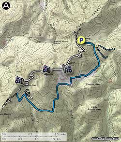
Cole Mountain is the sister circuit to the Mount Pleasant hike on the next ridge. If you are looking for a slightly longer hike, or a backpack, consider combining this hike with the Mount Pleasant route for a combined 11.3 mile figure eight circuit.

From the parking area continue down FS48 for 0.2 miles. Just before the road splits the Hotel Trail will be on the right marked by two posts with blue blazes. Head up the blue blazed trail for 0.1 miles arriving at a wooden horse gate (the trail on the left leads down to the Mount Pleasant parking area). Stay straight on the Hotel Trail passing through the horse gate. Descend slightly, then in 0.6 miles head back uphill climbing a spur of Cole Mountain.

Reach the spur ridge entering a clearing 0.4 miles from beginning your ascent. At the end of the clearing is one of the prettiest backcountry campsite in the Blue Ridge. Situated among a stand of mature oak, this site is suitable for multiple tents.

On the southwest side of the campsite, or on its right corner as you approached, the blue blazed trail descends a spur. Continue to follow the blue blazed trail, cross a small stream, then arrive at the crest of a second spur in 1.5 miles (there is an overgrown abandoned trail on the left here).

Continue downhill on the blue blazed trail into Cowcamp Gap, cross Little Cove Creek, then in 200 yards Cowcamp Gap Shelter is on your right. 100 yards to the right/southeast of the shelter in is a large campsite suitable for 4-6 tents, and 75 yards to the left/northwest of the shelter is a spring and the source of Little Cove Creek.

Continue up the blue blazed trail, on the opposite side of the creek than the shelter, and in 75 yards turn left on the Hotel Trail at the sign towards the Appalachian Trail (AT). (turning right and crossing Little Cove Creek at this point leads back to the spring and shelter. note: this side trail is also blue blazed)

Continue up the Hotel Trail for 0.5 miles to the intersection of the AT. Turn right/north on the white blazes AT (Appalachian Trail) and make two switchbacks, pass two view points, then arrive at the first open meadow and 4033ft summit of Cole Mountain in 1.2 miles. Continue, passing through a small stand of trees before reaching the the main Cole Mountain saddle, and largest of the high mountain meadows. The saddle provides a 360° panoramas with views of Pompey Mountain and Mount Pleasant.

After re-entering the forest at the end of the meadow, follow the white blazed AT as it winds its way downhill for the remaining 0.6 miles back to FS48 and hike parking area on the right.

Explore 37 trails near Vesuvius, VA

Know Before You Go

  • Cole Mountain in Vesuvius, VA offers a 5.7-mile hike with 360° meadow views comparable to Scotland or Switzerland.
  • The Hotel Trail, marked with blue blazes, leads to the Appalachian Trail (AT), providing access to the Cole Mountain summit and its panoramic views.
  • Cowcamp Gap along the trail offers a shelter, campsite, and spring, while the AT section features switchbacks, viewpoints, and open meadows leading to the summit.
Interactive topographic map for Cole Mountain Hike located in Vesuvius, VA. Click the "View Map" button to load GPS coordinates and trail markers.
Get directions
Distance
5.7 mi
Difficulty
Moderate
Type
Loop
Est. Time
2.9 hrs
Elev. Gain
1,436'
Rating
4.4
Added
January 23, 2025
Updated
April 04, 2025

Weather Forecast

Loading...
Total Change
999'
Ascent
1,436'
Descent
1,436'
Loading...

Download the GPX Data for Offline Use

Supporters get exclusive access to download trail routes to the MyHikes app for offline use. Stay prepared on your adventure, even without an internet connection! Become a Supporter today to unlock this feature and hike with confidence.

Download Cole Mountain Hike GPX Data to the MyHikes Mobile App

Features

Vista / Lookout Point
Dogs
Mountain Summit
Camping
Appalachian Trail logo Appalachian Trail hike

Points of interest

  1. Parking

    37.759665, -79.195266
  2. Main Trailhead

    37.759683, -79.195375

Safety information

For your own safety: plan ahead, let someone know where you'll be, and hike at your own risk.

Hazards

Snakes (Rattlesnakes, Copperheads, others)
Poison Ivy or Poison Oak

Availability

All seasons

Surface type

Dirt

Trip Reports (Reviews)

Rated 4.44 out of 5 based on 78 ratings.

Ready to help fellow hikers? Add a trip report to share your experience and provide valuable insights for other hikers!

By: Mark
5.7 miles / 9.2 km
March 11, 2017
What a great hike! Not too long, not too hard, incredible views from the summit, it was great. We hiked it as described in this guide on a cold but beautiful March day. Always looking for hikes to take visitors on and this will be on that list. A bit of fire damage along the way, but I suspect that is going to really accelerate growth this next year. Perfect place to take a picnic on a nice day if you hike in on the AT. The 0.6 hike to the summit will get their blood flowing and make them appreciate the incredible views. The only possible negative about this one is the access road is a little rough, but not so much you can't get a car up to the parking lot. Just be careful and go a little slower.
Legacy Review
By: Jeff S.
5.7 miles / 9.2 km
October 29, 2016
We did this hike combined with Mount Pleasant, making it an overnighter. We parked at the Mt. Pleasant trailhead and did that loop with only day packs. We got back to the car, grabbed our full packs, and took the Hotel Trail shortcut over to the Cold Mountain loop (it is easily spotted from the parking area). We did the loop clockwise to save the meadows for last. The first meadow campsite mentioned in the hike info is awesome. Big enough for a festival! Only about 1.5 miles from the parking area and would make for a nice family camping trip. We camped around Cowcamp Gap Shelter because of the water source. We broke camp the next morning and hiked on up to the meadows. They were beautiful, and so were the views! Be sure and spend some significant time up there to relax and soak it all in. We wrapped up our time there and hiked back down to the cars, having to walk on the road for the last .3 miles or so. This is a great hike and isn't too tough. Like others have said, you could just park at Hog Camp Gap and take the AT for a short hike up to the meadows.
Legacy Review
By: Kyle B
5.7 miles / 9.2 km
June 05, 2016
Some of the best views in Virginia! This is a great short hike or trail run and can even be shortened to a 1.2 miles out and back by heading out on the AT instead of the blue blaze and turning around at the meadows. If trail running, you can combine this with the start of the Mt Pleasant hike for a few extra flat miles. The road up is a bit rough at times but can be easily made with a 2 wheel drive low clearance car. The trail was overgrown in areas, so I would recommend long pants or expect some irritation from the grass/plants. It would make one of the best picnic spots too. Enjoy! Highly recommended if you're in the area
Legacy Review
No community routes found. To add your own hike as a Community Route for this Trail guide, leave a Trip Report with an attached GPX file.

Popular categories

Scenic mountain view representing vista trails
Vista trails
Scenic gorge of cascades representing waterfall trails
Waterfall hikes
Rugged mountain terrain representing summit trails
Summit trails
Scenic mountain view representing dog-friendly trails
Dog-friendly
Scenic campsite with a view representing camping trails
Camping trails
Appalachian Trail logo representing A.T. hikes
A.T. hikes

You May Also Like

25 Best Day Hikes in North Carolina - Discover the top 25 best day hikes in North Carolina, from breathtaking waterfalls to mountain peaks. Explore hidden gems, scenic views, and trails suitable for all skill levels, perfect for your next outdoor adventure.
Explore

25 Best Day Hikes in North Carolina

Discover the top 25 best day hikes in North Carolina, from breathtaking waterfalls to mountain peaks. Explore hidden gems, scenic views, and trails suitable for all skill levels, perfect for your next outdoor adventure.

Read
🍪 We use cookies to learn about site usage and to serve map tiles. You may block cookies manually in the browser. By continuing you agree. Learn more