Loading...

WINTER SALE! 50% OFF Supporter Accounts — now through January 31st. Learn More.

Cobble Hill Trail (West)

The Cobble Hill Trail (West) at Adirondack Park in Lake Placid, New York is a moderate 1.5-mile out-and-back hike that leads to the top of Cobble Hill and features stunning views of the surrounding Adirondack Mountains.

Alternative route: This route is the most-popular way to hike up to the top of Cobble Hill; however, if you wish to experience a more secluded (and albeit longer hike) to the top, you can follow our Cobble Hill Trail guide which leads hikers in from the east instead with a trailhead located on  NY-86.

Trail names: Cobble Hill Trail

Location: 424 Mirror Lake Drive, Lake Placid NY

Permitted uses: Hiking

Prohibited uses: There are no posted prohibited uses.

Hours: There are no posted hours at the trailhead.

Fees and Parking: There is no fee to use the trail. There is no parking area. Most visitors park alongside the road. Although the Northwood School is right next to the trailhead, parking is not allowed there. Hikers are encouraged to park in a public parking area closer to town, and walk from the parking area to the trailhead.

Pets: Dogs are allowed on the trail and need to be on a leash. Please take all dog waste with you when you hike. Do not leave waste on the trail.

Accessibility: This is not a wheelchair accessible trail.

Hiker amenities: There is no information Kiosk at the trailhead, No restrooms and no trash bins.

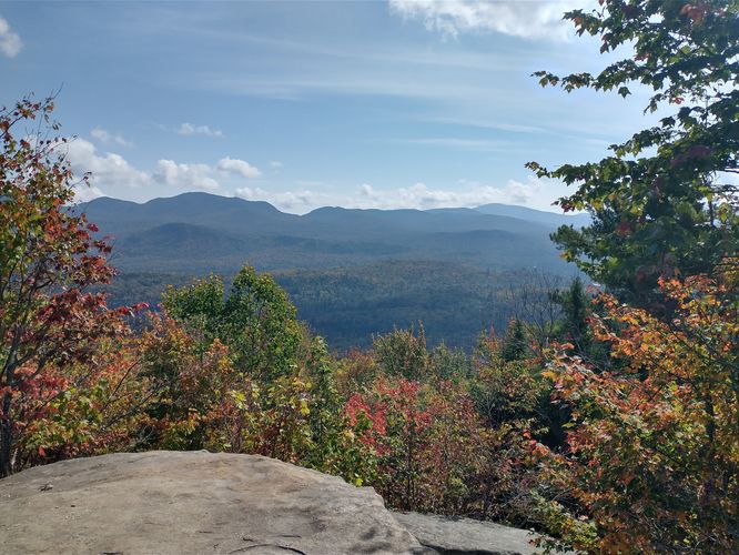
Length and Trail information: This hike is an out and back hike, is approximately 1.5 miles and is moderate to hard. There is an elevation gain of about 470 feet. The hike starts off on a sturdy, newly installed 250 foot boardwalk that brings hikers over a wetland area, leading to a densely wooded trail. The trail is blazed by blue markers and the pathway substrate through the woods is made up of packed crushed stones. There are very few trip hazards at the start of the trail but that changes once you reach the intersection of the Cobble Hill trail and Whitney Road. This section of Whitney Road is unmarked and is possibly an abandoned Class 6 road. After that intersection, the trail becomes more difficult and begins to ascend. The footing can be tricky with roots and rocks and the trail can often be crowded. There are an estimated 10,000 visitors to this trail each year, so plan on sharing the trail with other hikers of varying abilities and ages. Earlier in 2024, the trail was closed and trail workers rerouted the trail, worked on the substrate and installed stone steps. The steps have made Cobble Hill Trail more accessible as there are no longer any rock scrambles to navigate. That being said, there are still some very steep sections where caution is needed. The views from the summit are worth the effort, if you can see through the throng of hikers that are likely to be with you at the top. During our hike, we counted no less than 30 people at the summit, all taking pictures of the area around Lake Placid. All in all it's a quick hike with nice views, albeit very popular and crowded.

Private property: Please note that portions of this trail lead through private property that's kind enough to grant the public access to reach the top of Cobble Hill. As things can change in life, please ensure that this trail is still open to the public before hiking. If you wish to follow a 100% public land hike to reach the top, check out our Cobble Hill Trail guide with a trailhead along NY-86.

Explore 35 trails near Lake Placid, NY

Know Before You Go

  • The Cobble Hill Trail (West) is a popular, moderate 1.5-mile hike in Lake Placid, NY, offering stunning views from the summit but expect crowds.
  • Parking is limited to roadside and not permitted at the nearby school; consider walking from a public parking area in town.
  • While the trail is maintained with a boardwalk and stone steps, some steep and rocky sections remain; also, be aware that portions of the trail cross private property.
Interactive topographic map for Cobble Hill Trail (West) located in Lake Placid, NY. Click the "View Map" button to load GPS coordinates and trail markers.
Get directions
Distance
1.5 mi
Difficulty
Moderate
Type
Out-and-Back
Est. Time
45 min
Elev. Gain
498'
Rating
0.0
Added
October 10, 2024
Updated
December 13, 2024

Weather Forecast

Today
High -5°F
Sunny
Tonight
Low -12°F
Partly Cloudy
Sunday
High 7°F
Mostly Cloudy then Light Snow Likely
Sunday Night
Low 3°F
Heavy Snow
Monday
High 12°F
Heavy Snow
Monday Night
Low -4°F
Light Snow Likely
Tuesday
High 9°F
Mostly Cloudy
Tuesday Night
Low -4°F
Mostly Cloudy
Wednesday
High 9°F
Partly Sunny
Wednesday Night
Low -9°F
Mostly Cloudy
Thursday
High 6°F
Mostly Cloudy
Thursday Night
Low -7°F
Slight Chance Light Snow
Friday
High 9°F
Mostly Cloudy
Friday Night
Low -4°F
Mostly Cloudy
Loading...
Total Change
475'
Ascent
498'
Descent
498'
Loading...

Download the GPX Data for Offline Use

Supporters get exclusive access to download trail routes to the MyHikes app for offline use. Stay prepared on your adventure, even without an internet connection! Become a Supporter today to unlock this feature and hike with confidence.

Download Cobble Hill Trail (West) GPX Data to the MyHikes Mobile App

Features

Vista / Lookout Point
Dogs
Mountain Summit

Points of interest

  1. Parking

    44.293709, -73.974278
  2. Main Trailhead

    44.293972, -73.974096

Safety information

For your own safety: plan ahead, let someone know where you'll be, and hike at your own risk.

Hazards

Poison Ivy or Poison Oak
Rockfalls, Ledges, or Scrambles

Markers

Blaze Color

Blue

Blaze Dot Color

Blue

Availability

All seasons

Surface type

Dirt

Trip Reports (Reviews)

Your opinion matters! Be the first to rate this trail.

Ready to help fellow hikers? Add a trip report to share your experience and provide valuable insights for other hikers!

No community routes found. To add your own hike as a Community Route for this Trail guide, leave a Trip Report with an attached GPX file.

Popular categories

Scenic mountain view representing vista trails
Vista trails
Scenic gorge of cascades representing waterfall trails
Waterfall hikes
Rugged mountain terrain representing summit trails
Summit trails
Scenic mountain view representing dog-friendly trails
Dog-friendly
Scenic campsite with a view representing camping trails
Camping trails
Appalachian Trail logo representing A.T. hikes
A.T. hikes

You May Also Like

Colorado's Million Dollar Highway - Plan a day's drive adventure along the iconic Million Dollar Highway in Colorado. Explore the best short trails, roadside stops, waterfalls, vistas, ghost towns, and hot springs within a ~6 hour road trip.
Explore

Colorado's Million Dollar Highway

Plan a day's drive adventure along the iconic Million Dollar Highway in Colorado. Explore the best short trails, roadside stops, waterfalls, vistas, ghost towns, and hot springs within a ~6 hour road trip.

Read
Glacier's Going-to-the-Sun Road - Discover the breathtaking beauty of Glacier National Park along the iconic Going-to-the-Sun Road. From stunning roadside stops to picturesque waterfalls and vistas, this engineering marvel offers endless opportunities for exploration.
Explore

Glacier's Going-to-the-Sun Road

Discover the breathtaking beauty of Glacier National Park along the iconic Going-to-the-Sun Road. From stunning roadside stops to picturesque waterfalls and vistas, this engineering marvel offers endless opportunities for exploration.

Read
🍪 We use cookies to learn about site usage and to serve map tiles. You may block cookies manually in the browser. By continuing you agree. Learn more