The Coal Creek Waterfalls Hike in Cedar City, Utah is an easy 1.1-mile universally-accessible out-and-back hike that leads to two waterfalls within Coal Creek, the tallest being approximately 30-feet tall.
Trails
This hike follows two named trails: Cedar Canyon Trail, Coal Creek Trail.
Universal Access
Note that this trail is universally accessible from the parking lot up to the Upper Coal Creek Falls area. There is an off-trail portion of this hike that is not universally accessible, but all of the waterfalls on this trail are visible from the paved pathway.
Hike Description
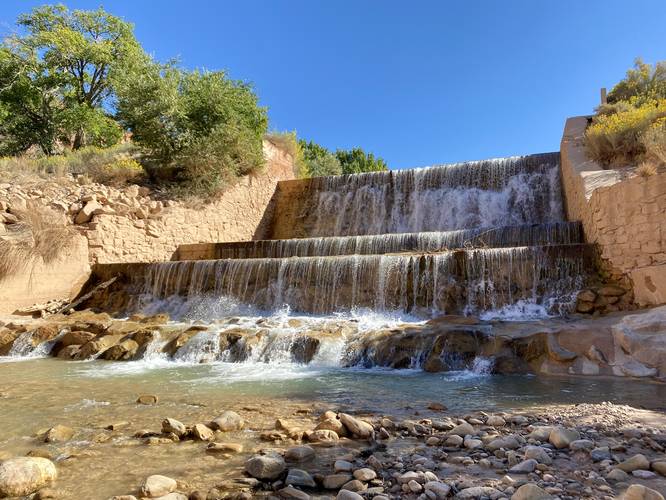
This hike begins at the main parking lot for the Cedar Canyon Trail at the coordinates provided. Hikers will head in on the main paved trail, first crossing the bridge that spans Coal Creek. Here, at the bridge crossing, is the first waterfall - aka Lower Coal Creek Falls. Lower Coal Creek Falls is about 12-15 feet tall in total and is a human-made waterfall.
Reaching Upper Coal Creek Falls
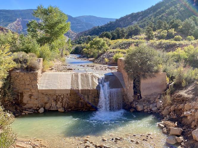
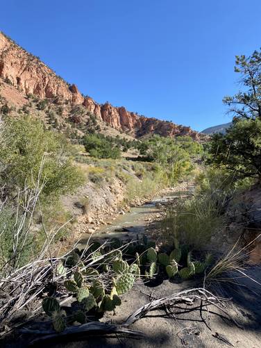
After visiting the first waterfall, hikers will head west for ~100-feet before taking a sharp left-hand turn onto the Coal Creek Trail (bike trail). Here, hikers will follow the Cedar Canyon Trail as it leads eastward and into Cedar Canyon. Along the way, hikers will get nice views of Coal Creek and the surrounding mountain / canyon slopes. Eventually, hikers will end up at the Upper Coal Creek Falls viewing area located around mile 0.45. In this GPS recording, the trail leads down and onto a gravel path, then down to Coal Creek and up the creek just a bit to reach the true base of Upper Coal Creek Falls, located around mile 0.55. Upper Coal Creek Falls is another human-made waterfall that runs down the creek along several tiers of cascades making-up the ~30-foot waterfall. Upper Coal Creek Falls is the main attraction for this hike, but the views of and from Lower Coal Creek Falls (in my opinion) were prettier as it gave more views into Cedar Canyon.
After visiting Upper Coal Creek Falls, hikers will take the same path heading back to parking for a ~1.1-mile out-and-back hike.
Parking
Hikers will find a medium-sized parking lot at the coordinates provided, located off of Center Street. The parking lot is large enough to fit just under 2 dozen vehicles as of September 2023.
Pets
Dogs are allowed only if leashed and cleaned up after.
Biking
Biking is permitted along this trail.
Trails
This hike follows two named trails: Cedar Canyon Trail, Coal Creek Trail.
Universal Access
Note that this trail is universally accessible from the parking lot up to the Upper Coal Creek Falls area. There is an off-trail portion of this hike that is not universally accessible, but all of the waterfalls on this trail are visible from the paved pathway.
Hike Description
This hike begins at the main parking lot for the Cedar Canyon Trail at the coordinates provided. Hikers will head in on the main paved trail, first crossing the bridge that spans Coal Creek. Here, at the bridge crossing, is the first waterfall - aka Lower Coal Creek Falls. Lower Coal Creek Falls is about 12-15 feet tall in total and is a human-made waterfall.
Reaching Upper Coal Creek Falls
After visiting the first waterfall, hikers will head west for ~100-feet before taking a sharp left-hand turn onto the Coal Creek Trail (bike trail). Here, hikers will follow the Cedar Canyon Trail as it leads eastward and into Cedar Canyon. Along the way, hikers will get nice views of Coal Creek and the surrounding mountain / canyon slopes. Eventually, hikers will end up at the Upper Coal Creek Falls viewing area located around mile 0.45. In this GPS recording, the trail leads down and onto a gravel path, then down to Coal Creek and up the creek just a bit to reach the true base of Upper Coal Creek Falls, located around mile 0.55. Upper Coal Creek Falls is another human-made waterfall that runs down the creek along several tiers of cascades making-up the ~30-foot waterfall. Upper Coal Creek Falls is the main attraction for this hike, but the views of and from Lower Coal Creek Falls (in my opinion) were prettier as it gave more views into Cedar Canyon.
After visiting Upper Coal Creek Falls, hikers will take the same path heading back to parking for a ~1.1-mile out-and-back hike.
Parking
Hikers will find a medium-sized parking lot at the coordinates provided, located off of Center Street. The parking lot is large enough to fit just under 2 dozen vehicles as of September 2023.
Pets
Dogs are allowed only if leashed and cleaned up after.
Biking
Biking is permitted along this trail.