Loading...

🎆 50% off 4th of July sale on Supporter Accounts — now through July 6! Learn More.

Church Rock Hike

Directions
Map
Pictures
Send to App
Distance:
7.3 Miles / 11.7 km
Type:
Out-and-Back
Difficulty:
Hard
Time to Hike:
3 hours, ~39 minutes
Features:
Surface Type:
Dirt
Park:
George Washington National Forest
Town:
Basye, Virginia
Directions:
38.724249, -78.869466
Added:
January 25, 2025
Updated:
April 04, 2025
Copy Trail Link Hiking this trail? Send a friend or family member a link to this trail guide for your own safety. Hike at your own risk (disclaimer)
Loading...
Loading...
1,521'

Total Change
1,759'

Ascent
1,754'

Descent

Download the Trail Route for Offline Use

Supporters get exclusive access to download trail routes to the MyHikes app for offline use. Stay prepared on your adventure, even without an internet connection! Become a Supporter today to unlock this feature and hike with confidence.

Send to App

Church Rock Hike

One of the most secluded panoramic vista hikes in western Virginia. Church Rock has expansive views to the north and east from its main rock outcrop and to the southeast from the Church Mountain ridgeline. The hike climbs Church Mountain with ten switchbacks and it can be challenging if the weather is warm, however the effort is more than worth it as you're rewarded with spectacular views from one of the least visited pinnacles in the Old Dominion.

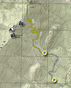
For most of the year you need to start the hike from the lower parking area as FR482 is closed and only opens from October 1 - January 10. If you do make the hike when it's open the total length will reduce to 5.6 miles. If you plan on doing this as a backpack there are two nice campsites along the route. The first is on the ridge just before the descent in to the saddle, and the second is in the saddle below the overlook from Church Rock. You will have to carry in water.

  • Mile 0.0 - From the lower parking area on FR482 pass around the closed gate and follow gravel FR482 for 1.0 miles. This area was recently timbered and provides nice views of the valley to the east.

  • Mile 1.0 - Arrive at the end of FR482, upper parking area, and the beginning of the Church Rock Trail. Follow the yellow blazed Church Rock Trail for 50 yards where it makes a sharp right. A old unused road continues straight. Remain right on the yellow trail and begin a gradual ascent of Church Mountain. The trail soon turns right and crosses the only stream of the hike. After 0.85 miles on the yellow trail make the first of ten switchbacks on the way to the ridge. As the Church Rock Trail climbs the mountain cross several old road cuts, make sure to follow the yellow blazes. At the second switchback there are views of Church Rock.

  • Mile 3.0 - Arrive at the ridgeline and intersection of the white blazed Talc Trail. The ridge here has very little underbrush and is mostly grass covered. Turn left on the white blazed Talc Trail and in 100 yards there is an opening in the trees to the south and views down the valley. Just before the Talc Trail descends into the saddle pass a campsite with room for multiple tents. Continue into the saddle and pass the second campsite of the hike. This campsite has log seats and more room for camping. Pass through the saddle and begin to climb and scramble through a rocky area. The trail veers left here so keep an eye out for the white blazes. Turn directly uphill steeply requiring hand-over-hand climbing for the remaining 60 yards to the summit.

  • Mile 3.8 - Arrive a the Church Rock overlook area where there are two main view outcrops. The westerly overlook has views along Church Mountain and north of the Great North Mountain range. Cross over to the main easterly overlook with more expansive views where on a clear day you can see both ranges of the Massanutten as well as the Shenandoah National Park in the far distance. This is the turn around point. Retrace your route back to the parking area.

  • Mile 7.3 - Arrive back at the parking area on FR482

Explore 68 trails near Basye, VA
  1. Parking

    38.724249, -78.869466
  2. Main Trailhead

    38.724249, -78.869466
No community routes found. To add your own hike as a Community Route for this Trail guide, leave a Trip Report with an attached GPX file.

Hazards

Ticks - Lyme Disease More Info (CDC)
Snakes
Poison Ivy/Oak
Rockfalls / Ledges / or Scrambles

Seasons

All

Blaze Color

Yellow

Trip Reports

Trail Guide By:
HikingUpward user profile picture
7.3 miles / 11.7 km

Weather Forecast

In Basye, VA

Explore Hiking Trails

You May Also Like

New York's Best Waterfalls - Whether you're planning a day hike, roadside stop, or a leisurely short walk, this guide provides hikers, travelers, and locals alike with 63 different locations to over 100 scenic waterfalls to help plan your next adventure!
Explore

New York's Best Waterfalls

Whether you're planning a day hike, roadside stop, or a leisurely short walk, this guide provides hikers, travelers, and locals alike with 63 different locations to over 100 scenic waterfalls to help plan your next adventure!

Read
25 Best Day Hikes in North Carolina - Discover the top 25 best day hikes in North Carolina, from breathtaking waterfalls to mountain peaks. Explore hidden gems, scenic views, and trails suitable for all skill levels, perfect for your next outdoor adventure.
Explore

25 Best Day Hikes in North Carolina

Discover the top 25 best day hikes in North Carolina, from breathtaking waterfalls to mountain peaks. Explore hidden gems, scenic views, and trails suitable for all skill levels, perfect for your next outdoor adventure.

Read

Before you boogie...

Find our trail guides useful? Consider becoming a Supporter to unlock perks!

MyHikes is an indie platform that makes exploring public trails easier for everyone. The platform has no investors, no ads, and is owned and operated by one person, Dave Miller. Dave has personally mapped and written over 1,800 trail guides on MyHikes for the public to explore. MyHikes has helped millions outdoor enthusiasts plan their next adventure.

But it takes a lot of time 🕦, money 💰, work, and espresso shots ☕ to run MyHikes, including hiking , mapping , writing , and publishing new trails with high-quality (accurate) information... along with software engineering (coding) the platform like building new features, website and mobile app development (iOS and Android), site maintainance . and much much more.

Supporters unlock website and mobile app perks with an annual one-time payment of $25 (you renew) 😎👍. Or you can simply make a Donation of your choice. Otherwise, you can support us by telling your friends about MyHikes - both quick and free 🎉

Admin user profile picture

Dave Miller
MyHikes Founder