After passing through a forested area the hike enters more open pine stands, then arrives at the first overlook with a view down to the North Fork of the Potomac River. The rock wall here, visible from the valley, has overlook after overlook for nearly half a mile, so don't be concerned if you get to the parking area and see a lot of vehicles, you're still almost guaranteed to get an overlook to yourself.
The Chimney Top hike is part of the northern section of the 24.7 mile North Fork Mountain Trail traverse hike with this area having the greatest density of overlooks. If you are considering doing the Chimney Top hike as an overnight backpack there are three good campsites. Two along the ridge wall, and the other at the Chimney Top summit. Keep in mind that there are no water sources on this 4.5 mile out/back route and you will need to carry water up with you.
-
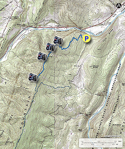
Mile 0.0 – From the parking area pass the information Kiosk and start up the blue triangle blazed North Fork Mountain Trail. The trail will wind upwards on the mountain through a forested area with good cover. Pine is also located along the trail which makes for a nice layer of needles to hike on. After climbing for 1.55 miles the trail makes its final switchback before the first overlook on the ridge wall. The trail will open up here with less cover.
-
Mile 1.74 - Turn right onto an unmarked side trail to the first overlook on the rock wall. This is the best overlook on the wall and has spectacular views into the valley of the North Fork of the Potomac River, New Creek Mountain, and the Dolly Sods massif. Continue uphill along the ridge wall as the trail steepens.
-
Mile 1.84 - Pass a campsite on the wall.
-
Mile 2.02 - Pass a second campsite on the wall. From this point the hike increases in steepness for the 0.4 miles to the Chimney Top spur trail intersection.
-
Mile 2.5 - Turn right uphill on the unblazed Chimney Top spur trail. The spur trail is the steepest portion of the of the hike.
-
Mile 2.7 - Arrive at the Chimney Top summit campsite. Pass through the campsite to see Chimney Top with sweeping views of the valley. There are multiple viewpoints from the summit of the valley below. Use extreme care if you decide to climb around the rocks. A fall here will be fatal. Return down the steep spur trail and retrace your route back to the parking area.
- Mile 4.9 - Arrive back at Smoke Hole Rd. and parking area.