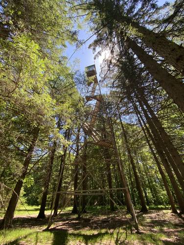
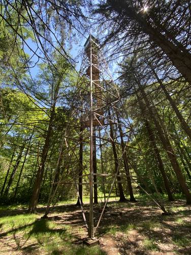
Exploring the Cherry Springs Fire Tower near the Cherry Springs State Park in the Susquehanna State Forest in Potter County, Pennsylvania is the subject at hand of this 0.1-mile walk.
The following newspaper clipping captures the excitement about it's building in October of 1917:
"An observation tower is being built on the highest point in the Black Forest, about one and one-half miles from Cherry Springs, which will be used for the sighting of forest fires in the county. The tower will be 70 feet high when completed and is at the present time erected to about 40 feet. It is constructed of steel and is being erected by the State Forestry Department. The tower will be connected by telephone so that news of any forest fire can be quickly spread. This tower will no doubt prove of considerable interest to tourists.--Westfield Free Press." (The Wellsboro Agitator)
Oh how times have changed. Of these fire towers that once dotted the forested landscape of Pennsylvania, few are left standing. Fire towers were popular in the early 1900s as the primary way for spotting wildfires. Perched high on the mountain top, these manned towers provided an excellent view point for smoke columns and flames. This tower at Cherry Springs in Potter County is still standing, but it appears to have been abandoned now for several decades.
There is a forest road service with a turn around loop that tracks about 200 feet from the State Route 44 Roadway to the Cherry Springs tower. It is probably best to visit this old tower by foot and come in on the hiking trail to truly enjoy this wonderful site. This steel relic continues to garner interest from the hikers trekking along the STS.
There is still an operational fire tower at the top of Brooks Run along the Bucktail Path in Elk State Forest in Cameron County.
Trails
This structure is located just off of the State Route 44, and can be accessed by a short forest service road from the public roadway.
The Susquehanna Trail System (STS) trail follows along this route. The orange blazes of the STS follows this same access road, and tracks under the tower, and exits out the back of the site onto the Short Run Road trail (open to hiking only).
Length and Difficulty
No real hiking is required to visit this Cherry Springs Fire Tower. Visitors can walk a short distance from the parking area along the forest service road to see the tower and the cabin area.
It is probably best to visit this old tower by foot and come in on the hiking trail to truly enjoy this wonderful site.
Parking
Hikers can find parking at the coordinates provided; next to the tower. It is important not park so as to block authorized vehicles from using the state forest road.
Pets
Dogs are allowed if leashed.
Camping and Backpacking
Backpackers are allowed to camp off-trail only within the Susquehanna State Forest section of this route. Backpackers need to follow the state forest rules and regulations for dispersed / primitive / backcountry camping.
The Susquehanna Trail System is by far the best place to camp in this area; and it would be best for the camper to park at another designation parking area for any extended hikes or overnight camping trips.
Hikers can find overnight parking for extended hiking trips at the Bureau of Forestry headquarters on US Route 6 on top of Denton Hill. The lot is large enough to hold dozens of vehicles with some amenities including maps and informational kiosks, and restrooms, and serves as the "Northern Gateway" which provides access to the northern portion of the STS loop.. See Duck Ponds Short Loop for extended trip parking coordinates and details to find the route to the STS.
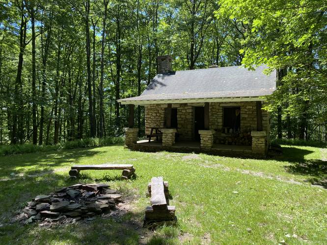
Forest Service Cabin with Outdoor Water Source and Restroom Faculty
There is a small Cabin at the tower site, presumably once used by the Forest Service who monitor from the tower for wildfires in an bygone era.
There is a latched and locked outdoor restroom faculty near the cabin and is not-accessible by hikers. No outdoor water sources are available at this tower site.
Access to climb the fire tower is not allowed. The bottom sections of the stairs have been removed.
Biking
Biking is only permitted along the service road, and would make for a quick out-and-back bike ride. Biking is allowed along the multi-use trails in the Cherry Springs State Park area and public roads in the area except for the STS. Additionally, horses are not allowed along the STS.
The following newspaper clipping captures the excitement about it's building in October of 1917:
"An observation tower is being built on the highest point in the Black Forest, about one and one-half miles from Cherry Springs, which will be used for the sighting of forest fires in the county. The tower will be 70 feet high when completed and is at the present time erected to about 40 feet. It is constructed of steel and is being erected by the State Forestry Department. The tower will be connected by telephone so that news of any forest fire can be quickly spread. This tower will no doubt prove of considerable interest to tourists.--Westfield Free Press." (The Wellsboro Agitator)
Oh how times have changed. Of these fire towers that once dotted the forested landscape of Pennsylvania, few are left standing. Fire towers were popular in the early 1900s as the primary way for spotting wildfires. Perched high on the mountain top, these manned towers provided an excellent view point for smoke columns and flames. This tower at Cherry Springs in Potter County is still standing, but it appears to have been abandoned now for several decades.
There is a forest road service with a turn around loop that tracks about 200 feet from the State Route 44 Roadway to the Cherry Springs tower. It is probably best to visit this old tower by foot and come in on the hiking trail to truly enjoy this wonderful site. This steel relic continues to garner interest from the hikers trekking along the STS.
There is still an operational fire tower at the top of Brooks Run along the Bucktail Path in Elk State Forest in Cameron County.
Trails
This structure is located just off of the State Route 44, and can be accessed by a short forest service road from the public roadway.
The Susquehanna Trail System (STS) trail follows along this route. The orange blazes of the STS follows this same access road, and tracks under the tower, and exits out the back of the site onto the Short Run Road trail (open to hiking only).
Length and Difficulty
No real hiking is required to visit this Cherry Springs Fire Tower. Visitors can walk a short distance from the parking area along the forest service road to see the tower and the cabin area.
It is probably best to visit this old tower by foot and come in on the hiking trail to truly enjoy this wonderful site.
Parking
Hikers can find parking at the coordinates provided; next to the tower. It is important not park so as to block authorized vehicles from using the state forest road.
Pets
Dogs are allowed if leashed.
Camping and Backpacking
Backpackers are allowed to camp off-trail only within the Susquehanna State Forest section of this route. Backpackers need to follow the state forest rules and regulations for dispersed / primitive / backcountry camping.
The Susquehanna Trail System is by far the best place to camp in this area; and it would be best for the camper to park at another designation parking area for any extended hikes or overnight camping trips.
Hikers can find overnight parking for extended hiking trips at the Bureau of Forestry headquarters on US Route 6 on top of Denton Hill. The lot is large enough to hold dozens of vehicles with some amenities including maps and informational kiosks, and restrooms, and serves as the "Northern Gateway" which provides access to the northern portion of the STS loop.. See Duck Ponds Short Loop for extended trip parking coordinates and details to find the route to the STS.
Forest Service Cabin with Outdoor Water Source and Restroom Faculty
There is a small Cabin at the tower site, presumably once used by the Forest Service who monitor from the tower for wildfires in an bygone era.
There is a latched and locked outdoor restroom faculty near the cabin and is not-accessible by hikers. No outdoor water sources are available at this tower site.
Access to climb the fire tower is not allowed. The bottom sections of the stairs have been removed.
Biking
Biking is only permitted along the service road, and would make for a quick out-and-back bike ride. Biking is allowed along the multi-use trails in the Cherry Springs State Park area and public roads in the area except for the STS. Additionally, horses are not allowed along the STS.