The Centralia Active Smoking Vent in Centralia, Pennsylvania is an easy 0.1-mile out-and-back walk that leads to a vent in the ground where smoke rises out from the active coal mile fire underneath the ghost town.
Warning
Noxious fumes: This area is full of noxious, toxic, and deadly fumes that surface from the underground coal mine fire in the abandoned town of Centralia. By standing around for too long, even just a few minutes, can cause headaches. It's smart to not actually hang out here for very long, but it's an interesting spot for the curious.
Walk
This is not a hike but rather a short walk through the woods to reach a small cliff / rock out cropping area where heat and smoke rise out of the ground. Visitors will first walk into the woods to find a large cliff area to your right-hand side; however, the active vent area is located up on a hill on the left-hand side -- look for a small path that leads up a steep hill and ends at a dead-end rock outcropping. If you walk up to the top -- it's smart to hold your breath for as long as humanly-possible -- you'll find smoke puffing out of the cracks in the rock. During warmer months, like when I visited, the smoke is much harder to see in a photograph but it's pretty easy to see in-person. Again, don't stay for long for obvious deadly reasons.
Parking
Visitors will find a parking turnout near the coordinates provided. The turnout is large enough to pull your car off of the road.
Pets
Dogs are allowed only if leashed and must be cleaned up after. Note that during our visitor in October 2023, there was broken glass near the start of this walk, so it's probably best to leave your dog in the car if you bring them with you.
Warning
Noxious fumes: This area is full of noxious, toxic, and deadly fumes that surface from the underground coal mine fire in the abandoned town of Centralia. By standing around for too long, even just a few minutes, can cause headaches. It's smart to not actually hang out here for very long, but it's an interesting spot for the curious.
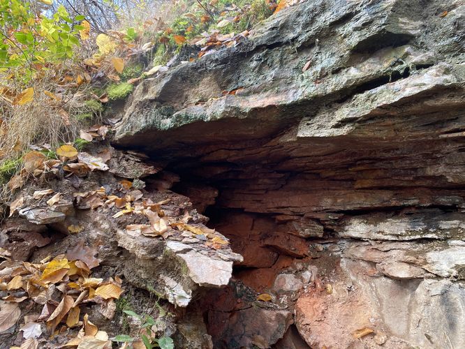
Walk
This is not a hike but rather a short walk through the woods to reach a small cliff / rock out cropping area where heat and smoke rise out of the ground. Visitors will first walk into the woods to find a large cliff area to your right-hand side; however, the active vent area is located up on a hill on the left-hand side -- look for a small path that leads up a steep hill and ends at a dead-end rock outcropping. If you walk up to the top -- it's smart to hold your breath for as long as humanly-possible -- you'll find smoke puffing out of the cracks in the rock. During warmer months, like when I visited, the smoke is much harder to see in a photograph but it's pretty easy to see in-person. Again, don't stay for long for obvious deadly reasons.
Parking
Visitors will find a parking turnout near the coordinates provided. The turnout is large enough to pull your car off of the road.
Pets
Dogs are allowed only if leashed and must be cleaned up after. Note that during our visitor in October 2023, there was broken glass near the start of this walk, so it's probably best to leave your dog in the car if you bring them with you.