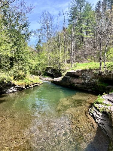
Cedar Run Swimming Hole
This is not a hike and not a walk but rather a couple of steps from parking to the creek where Summer-time visitors can take a dip in the deep creek swimming hole in Cedar Creek. This swimming hole is also a good spot to fish during the Spring. If swimming, swim at your own risk.
Parking
Visitors will find parking at the coordinates provided along Leetonia Road. The lot is large enough to fit 3 vehicles. Do not overcrowd the lot.
Pets
Dogs are allowed only if leashed and cleaned up after.
Know Before You Go
Interactive topographic map for Cedar Run Swimming Hole located in Leetonia, PA. Click the "View Map" button to load GPS coordinates and trail markers.
View map
Get directions
- Distance
- N/A
- Difficulty
- Easy
- Type
- Out-and-Back
- Est. Time
- 5 min
- Elev. Gain
- 5'
- Rating
- 0.0
- Added
- March 25, 2023
- Updated
- April 06, 2023
Weather Forecast
Today
High
81°F
Sunny
Tonight
Low
55°F
Mostly Clear
Saturday
High
82°F
Sunny
Saturday Night
Low
59°F
Partly Cloudy
Sunday
High
84°F
Mostly Sunny then Chance Showers And Thunderstorms
Sunday Night
Low
61°F
Chance Showers And Thunderstorms
Monday
High
84°F
Showers And Thunderstorms Likely
Monday Night
Low
63°F
Showers And Thunderstorms Likely then Chance Showers And Thunderstorms
Tuesday
High
81°F
Showers And Thunderstorms Likely
Tuesday Night
Low
60°F
Showers And Thunderstorms Likely
Wednesday
High
79°F
Partly Sunny then Chance Showers And Thunderstorms
Wednesday Night
Low
57°F
Chance Showers And Thunderstorms then Partly Cloudy
Thursday
High
80°F
Sunny
Thursday Night
Low
58°F
Mostly Clear
Don't let Google decide who you trust.


Loading...
<strong>Trail map and elevation chart not rendering in print mode?</strong> Simply scroll to the trail map section, then try printing again!
Features
- Water Source
-
 PA Wilds
Points of interest
-
Parking
41.579687, -77.473889 -
Main Trailhead
41.579804, -77.47406
Safety information
For your own safety: plan ahead, let someone know where you'll be, and hike at your own risk.
Availability
All seasons
Surface type
Dirt
Trip Reports (Reviews)
Ready to help fellow hikers? Add a trip report to share your experience!
0
miles
/ 0 km
May 03, 2024
Hiking
Pictures
No community routes found. To add your own hike as a Community Route for this Trail guide, leave a Trip Report with an attached GPX file.


You may also like

Explore
Pennsylvania's Grand Canyon
Explore Pennsylvania's Grand Canyon, officially named Pine Creek Gorge, including hiking trails, vistas, overlooks, waterfalls, backcountry campsites, backpacking trails.

Explore
New York's Best Waterfalls
Whether you're planning a day hike, roadside stop, or a leisurely short walk, this guide provides hikers, travelers, and locals alike with 63 different locations to over 100 scenic waterfalls to help plan your next adventure!

Explore
25 Best Day Hikes in West Virginia
Discover 25 of the best day hikes in West Virginia, from scenic overlooks to wilderness trails—perfect for every level of hiker.

Explore
Best of the Alps: Hiking, Adventure & Scenery
Plan your ultimate European Alps adventure! Discover the best hiking trails, epic scenery, and villages in the Swiss Alps, Dolomites, Chamonix, and Lake Como.
tioga state forest

