Loading...

🎉 Enjoy a Free 7-Day Supporter Trial and Unlock Exclusive Perks — No Credit Card Required. Learn more.

Cedar Run Hike

Directions
Map
Pictures
Send to App
Distance:
3.9 Miles / 6.3 km
Type:
Out-and-Back
Difficulty:
Moderate
Time to Hike:
1 hour, ~57 minutes
Features:
Surface Type:
Dirt
Park:
Shenandoah National Park
Town:
Syria, Virginia
Directions:
38.555777, -78.386699
Added:
March 18, 2025
Updated:
April 05, 2025
Copy Trail Link Hiking this trail? Send a friend or family member a link to this trail guide for your own safety. Hike at your own risk (disclaimer)
Loading...
Loading...
1,741'

Total Change
1,765'

Ascent
1,770'

Descent

Download the Trail Route for Offline Use

Supporters get exclusive access to download trail routes to the MyHikes app for offline use. Stay prepared on your adventure, even without an internet connection! Become a Supporter today to unlock this feature and hike with confidence.

Send to App

Cedar Run Hike

Not very long, this down and back hike can still be somewhat of a workout as you gain 1,500 ft on the way back in only 1.7 miles. If you make the hike in the early spring, Cedar Run should be flowing with several beautiful ponds and small waterfalls. The main falls at the base of the hike have a great natural water slide and there is a small swimming hole about 40 yards beyond it.


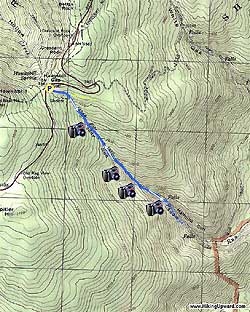
Start the hike by heading down Cedar Run Trail. Pass the Big Meadows Trail that comes in from the left after just 20 yards, continue downward on the Cedar Run Trail where the grade will gradually increase. In about 0.8 miles, Cedar Run will become visible on your right with several small ponds along the way.

At 1.5 miles cross Cedar Run and climb the opposite bank. 0.2 miles further you arrive at the Cedar Run natural water slide, with a small pond at its base. In 50 more yards, reach your destination, the tallest falls on the hike with Half Mile Cliffs visible on the opposite site of the run. Leave the trail and have lunch at the small pond at the bottom of the falls.

To return just retrace your steps up the trail to the parking area.

Explore 88 trails near Syria, VA
  1. Parking

    38.555777, -78.386699
  2. Main Trailhead

    38.556045, -78.386722
No community routes found. To add your own hike as a Community Route for this Trail guide, leave a Trip Report with an attached GPX file.

Hazards

Ticks - Lyme Disease More Info (CDC)
Snakes
Poison Ivy/Oak

Seasons

All

Trip Reports

Trail Guide By:
HikingUpward user profile picture
3.9 miles / 6.3 km

Weather Forecast

In Syria, VA

Explore Hiking Trails

You May Also Like

New York's Best Waterfalls - Whether you're planning a day hike, roadside stop, or a leisurely short walk, this guide provides hikers, travelers, and locals alike with 63 different locations to over 100 scenic waterfalls to help plan your next adventure!
Explore

New York's Best Waterfalls

Whether you're planning a day hike, roadside stop, or a leisurely short walk, this guide provides hikers, travelers, and locals alike with 63 different locations to over 100 scenic waterfalls to help plan your next adventure!

Read
25 Best Day Hikes in North Carolina - Discover the top 25 best day hikes in North Carolina, from breathtaking waterfalls to mountain peaks. Explore hidden gems, scenic views, and trails suitable for all skill levels, perfect for your next outdoor adventure.
Explore

25 Best Day Hikes in North Carolina

Discover the top 25 best day hikes in North Carolina, from breathtaking waterfalls to mountain peaks. Explore hidden gems, scenic views, and trails suitable for all skill levels, perfect for your next outdoor adventure.

Read

Before you boogie...

Find our trail guides useful? Consider becoming a Supporter to unlock perks!

MyHikes is an indie platform that makes exploring public trails easier for everyone. The platform has no investors, no ads, and is owned and operated by one person, Dave Miller. Dave has personally mapped and written over 1,800 trail guides on MyHikes for the public to explore. MyHikes has helped millions outdoor enthusiasts plan their next adventure.

But it takes a lot of time 🕦, money 💰, work, and espresso shots ☕ to run MyHikes, including hiking , mapping , writing , and publishing new trails with high-quality (accurate) information... along with software engineering (coding) the platform like building new features, website and mobile app development (iOS and Android), site maintainance . and much much more.

Supporters unlock website and mobile app perks with an annual one-time payment of $25 (you renew) 😎👍. Or you can simply make a Donation of your choice. Otherwise, you can support us by telling your friends about MyHikes - both quick and free 🎉

Admin user profile picture

Dave Miller
MyHikes Founder