Loading...

🎆 50% off 4th of July sale on Supporter Accounts — now through July 6! Learn More.

Cedar Run Falls & Swimming Hole

Directions
Map
Pictures
Send to App
Distance:
0 Miles / 0 km
Type:
Out-and-Back
Difficulty:
Easy
Time to Hike:
~5 minutes
Features:
PA Wilds
Surface Type:
Dirt
Park:
Tioga State Forest
Town:
Cedar Run, Pennsylvania
Directions:
41.55494, -77.459126
Added:
March 25, 2023
Updated:
March 26, 2023
Copy Trail Link Hiking this trail? Send a friend or family member a link to this trail guide for your own safety. Hike at your own risk (disclaimer)
Loading...

Download the Trail Route for Offline Use

Supporters get exclusive access to download trail routes to the MyHikes app for offline use. Stay prepared on your adventure, even without an internet connection! Become a Supporter today to unlock this feature and hike with confidence.

Send to App

Cedar Run Falls & Swimming Hole

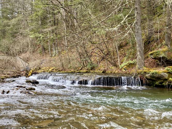
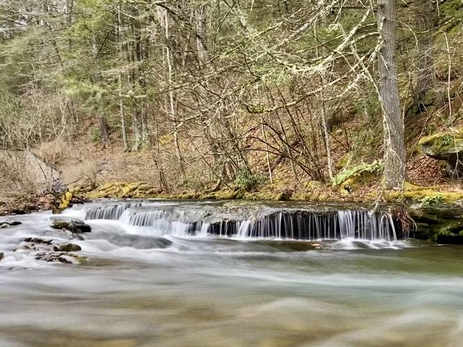
Cedar Run Falls & Swimming Hole near Cedar Run, Pennsylvania is an easy 0.1-mile out-and-back walk to reach a view of the 2-foot tall, 20-foot long Cedar Run Falls.

This is not a hike but simply a walk to the banks of Cedar Run where Mine Hole Run spills into the larger Cedar Run creek. The walk down to the banks of Cedar Run provides a view the scenic Cedar Run Falls. Cedar Run Falls is only 2-feet tall but about 20-feet wide with a pool at its base, which provides access for wading or cooling off during Summer months.

Swimming Hole
This waterfall has a potential swimming hole during Summer months; however, it's not very deep like other local holes and may be better for wading or cooling off.

Parking
Visitors will find a small parking turnout at the coordinates provided along Leetonia Road or they can park at the larger turnout just 150-feet east of there at the end of Mine Hole Road.

Pets
Dogs are allowed if leashed and cleaned up after.
Explore 276 trails near Cedar Run, PA
  1. Parking

    41.55494, -77.459126
  2. Main Trailhead

    41.554761, -77.459029
  3. Cedar Run Falls (approx. 2-feet tall, 20-feet wide)

    41.554906, -77.458922
    Cedar Run Falls (approx. 2-feet tall, 20-feet wide)
  4. Cedar Run Falls (approx. 2-feet tall, 20-feet wide)

    41.554906, -77.458922
    Cedar Run Falls (approx. 2-feet tall, 20-feet wide)
No community routes found. To add your own hike as a Community Route for this Trail guide, leave a Trip Report with an attached GPX file.

Hazards

Ticks - Lyme Disease More Info (CDC)
Snakes

Seasons

All

Weather Forecast

In Cedar Run, PA

Explore Hiking Trails

You May Also Like

Colorado's Million Dollar Highway - Plan a day's drive adventure along the iconic Million Dollar Highway in Colorado. Explore the best short trails, roadside stops, waterfalls, vistas, ghost towns, and hot springs within a ~6 hour road trip.
Explore

Colorado's Million Dollar Highway

Plan a day's drive adventure along the iconic Million Dollar Highway in Colorado. Explore the best short trails, roadside stops, waterfalls, vistas, ghost towns, and hot springs within a ~6 hour road trip.

Read
New York's Best Waterfalls - Whether you're planning a day hike, roadside stop, or a leisurely short walk, this guide provides hikers, travelers, and locals alike with 63 different locations to over 100 scenic waterfalls to help plan your next adventure!
Explore

New York's Best Waterfalls

Whether you're planning a day hike, roadside stop, or a leisurely short walk, this guide provides hikers, travelers, and locals alike with 63 different locations to over 100 scenic waterfalls to help plan your next adventure!

Read

Before you boogie...

Find our trail guides useful? Consider becoming a Supporter to unlock perks!

MyHikes is an indie platform that makes exploring public trails easier for everyone. The platform has no investors, no ads, and is owned and operated by one person, Dave Miller. Dave has personally mapped and written over 1,800 trail guides on MyHikes for the public to explore. MyHikes has helped millions outdoor enthusiasts plan their next adventure.

But it takes a lot of time 🕦, money 💰, work, and espresso shots ☕ to run MyHikes, including hiking , mapping , writing , and publishing new trails with high-quality (accurate) information... along with software engineering (coding) the platform like building new features, website and mobile app development (iOS and Android), site maintainance . and much much more.

Supporters unlock website and mobile app perks with an annual one-time payment of $25 (you renew) 😎👍. Or you can simply make a Donation of your choice. Otherwise, you can support us by telling your friends about MyHikes - both quick and free 🎉

Admin user profile picture

Dave Miller
MyHikes Founder