This can be done as a 2 day backpack with camping around mile 16.6
at the Manor Area Campground of Cunningham Falls State Park,
reservations suggested. Cars cannot be left at the Gambrill SP Trail
System Parking Area overnight. You can park at Gambrill State Park
(call them) and take the Red access trail from there to the Trail
System Parking Area.
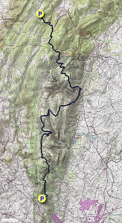
No camping is allowed along the Catoctin Trail. This hike will take you through 2 state parks, a Municipal Forest and a National Park. You will also cross many streams and hike by at least 4 beautiful ponds. Watch out for mountain bikers on much of the trail. The directions are not a mile by mile description but enough information for you to keep your orientation and know how far you have come.
- Mile 0.0 – Parking is at the Gambrill State Park Trail System Parking Area. The blue blazed trail begins to the right of the information kiosk. Follow the blue blazes as many trails are multi-blazed. There are sections marked better than others, so pay close attention.
- Mile 1.5 – Keep straight on the blue-blazed Catoctin Trail as the green and black blazed trails head uphill on the left.
- Mile 5.7 – Reach Hamburg Road. Go straight across road, next section does not have many blazes.
- Mile 7.5 – Make a decision to cross the creek straight ahead (cuts out 0.5 miles) or go around the pond. Go right for about 0.2 miles to a fork in the road, bear to the left, go another 0.2 miles and take a left walking on the far side of the pond. Cross Steep Creek and very quickly reach the fire road and take a right, this is mile 8.0.
- Mile 9.4 – Delauter Rd, you will pass a shed and house very close to this intersection. At the road take a right and in about 40 yards take a left back onto the trail.
- Mile 10.4 – Bear hard right on trail and head downhill towards Steep Creek.
- Mile 11.8 – Cross Steep Creek, multiple branches if the water is flowing. In 0.1 miles after crossing creek, the trail bears hard right towards Fishing Creek Rd.
- Mile 11.9 – Fishing Creek Rd, bear right then left at the yellow road barrier.
- Mile 14.4 – Thurmont Rock Overlook, on the right. It is a steady down to the Manor Area of Cunningham Falls State Park from the overlook
- Mile 16.3 – Catoctin Hollow Rd.
- Mile 16.5 – Little Hunting Creek. Cross creek and head towards parking area and then up the road to the Visitor Center, we ate lunch here. If water is flowing too high on the creek you may have to hike down to Route 15 and cross there, then head back towards the Visitor Center.
- Mile 16.6 – Manor Visitor Center. If doing a 2 day backpack, the camping area is just up the road from the Visitor Center. The white spur trail directly across the road takes you back to the Catoctin Trail and begins the most strenuous climb of the trail
- Mile 18.3 – Bob's Hill Overlook intersection. A 1142' climb from the Visitor Center. We took a right to see the view to the east (credit Greg Blair).
- Mile 21.5 – Catoctin Hollow Rd, second time you have crossed this. There is an entrance station to the left. Cross the road to continue. Taking a right on the road would lead you to the Entrance to the Houck Camp Area. If the creek is too deep you may have to go that way and then hook back into the trail at the camp area.
- Mile 21.6 – Cross Hunting Creek.
- Mile 22.1 – Cross Campground Rd, to the left and up the road is the Houck Campground area.
- Mile 23.5 – Route 77, take a right and at end of road barrier cross the road into Catoctin Mountain Park to continue on the trail
-
Mile 24.8 – Park Central Rd, Camp David is about 0.8 miles to the east as the crow flies
Mile 25.0 – Manahan Rd. Walk on road for about 0.25 miles then bear left back onto trail. It will parallel the road until you cross an unnamed creek in 0.9 miles - Mile 25.9 – Trail crosses a creek and starts to head away from the road, on the right you will see double metal drainage pipes bringing the creek under the road
- Mile 26.2 – Foxville/Deerfield Rd, bear right onto road then turn left towards Owens Creek Campground, cross over Owens Creek Bridge and in about 40 yards turn right onto trail. Begin a steady climb for 1 mile then reaching a T-intersection/Open Field in another 0.6 miles.
- Mile 27.8 – T-intersection/Open Field, there are blue blazes to the right at this intersection, ignore them and turn left reaching the Mt Zion Road Parking Area in 0.1 miles
- Mile 27.9 – Mt Zion Road Parking Area. Mt Zion United Methodist Church is visible from the parking area (Parking Coordinates 39.6722, -77.4983).
Note: Bypassing Bob's Hill Overlook and the circuit around the pond at Mile 7.5 reduces the trail by about 0.5 miles. Be careful when crossing fast flowing high creeks, don't cross if too dangerous, use an alternate route.