Loading...

WINTER SALE! 50% OFF Supporter Accounts — now through January 31st. Learn More.

Catoctin Mountain Park Hike

It's easy to see why Catoctin Mountain Park is one of the most popular hiking areas in Maryland. With great overlooks, including Chimney Rock, Thurmont Vista, the Blue Ridge Summit Overlook, and Hog Rock, plus a side trip to Cunningham Falls, you'll have more Kodak moments than you can shake a stick at!

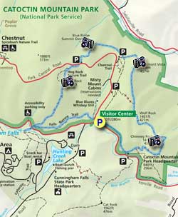
If you want to avoid the crowds, at least in the morning, try to get to the parking area by no later than 8 a.m. on weekends and there's a good chance you'll have Chimney Rock to yourself. The trails in Catoctin Mountain Park are not blazed, but are very well signed, and if you take a map along you shouldn't have any trouble following this circuit.

  • Mile 0.0 – From the parking area at the Visitors Center on Foxville Rd. MD77 start the hike a the far end of the eastern parking area. There are two trails that start at this point. Take the trail on the right that goes towards the Catoctin Mountain Park Headquarters and Chimney Rock. Follow the trail as it parallels Foxville Rd for 0.9 miles.
  • Mile 0.9 - At the intersection for the Catoctin Mountain Park Headquarters turn left uphill towards Chimney Rock, then in 0.1 miles pass the intersection for the Crows Nest Campground loop.
  • Mile 1.4 - Arrive a the ridgeline and other end of the Crows Nest Campground loop. Turn left towards Chimney Rock and pass around the eastern side if the ridge before reaching the Chimney Rock intersection. Turn left for the short walk to Chimney Rock.
  • Mile 2.0 - From Chimney Rock head back to the main trail and follow the signage for Wolf Rock.
  • Mile 2.4 - Wolf Rock is a quartzite ledge that was deposited 550 million years ago, with the quartzite forming 250 million yeas ago. Since then the softer sediments above the quartzite have eroded leaving this spectacular feature. If you climb the Wolf Rock ridge and follow it to its northern end there are nice views of the Thurmont Valley below. From Wolf Rock continue along the trail and pass another intersection that leads to Park Central Rd. From this intersection it's 0.7 miles to the Thurmont Overlook.
  • Mile 3.4 - Leaving Thurmont Overlook the trail will head downhill for 0.4 miles to a 4-way intersection.
  • Mile 3.8 - Turn right following the signage to Hog Rock. The trail winds around the northern section of the mountain, then climbs before arriving at the Blue Ridge Summit Overlook.
  • Mile 4.6 - From the Blue Ridge Summit Overlook continue on the trail to the Hog Rock parking area on Park Central Rd in another 0.3 miles.
  • Mile 5.3 - From the Hog Rock parking area cross Park Central Rd towards Hog Rock. Pass one end of the Hog Rock Nature Loop, then shortly arrive at Hog Rock.
  • Mile 6.3 - From Hog Rock stay on the trail to the left that leads downhill towards Cunningham Falls (the trail just to the right is the terminus of the other end of the Hog Rock Nature loop). The trail becomes more steep and rocky then reaches the intersection of the Falls Nature Trail, and Foxville Rd MD77.
  • Mile 6.5 - Stay straight, crossing Foxville Rd, then following the wooden walkway for 0.3 miles to Cunningham Falls.
  • Mile 6.6 - Retrace your steps re-crossing Foxville Rd to the intersection of the Falls Nature Trail you just passed. Now turn right on the Falls Nature Trail and hike the remaining 1.2 miles back to the Visitor Center and parking area.
  • Mile 7.8 - Arrive back at the Visitor Center.
Explore 27 trails near Thurmont, MD

Know Before You Go

  • This 7.8-mile hike in Catoctin Mountain Park offers numerous scenic overlooks, including Chimney Rock, Thurmont Vista, Blue Ridge Summit Overlook, and Hog Rock, with a side trip to Cunningham Falls.
  • To avoid crowds, especially on weekends, arrive at the visitor center parking area by 8 a.m.
  • The trails are well-signed, but bringing a map is recommended to follow the circuit, which includes diverse attractions like Wolf Rock, Cunningham Falls, and multiple overlooks.
Interactive topographic map for Catoctin Mountain Park Hike located in Thurmont, MD. Click the "View Map" button to load GPS coordinates and trail markers.
Get directions
Distance
7.8 mi
Difficulty
Moderate
Type
Loop
Est. Time
3.9 hrs
Elev. Gain
1,617'
Rating
3.8
Added
March 20, 2025
Updated
June 06, 2025

Weather Forecast

Loading...
Total Change
824'
Ascent
1,617'
Descent
1,621'
Loading...

Download the GPX Data for Offline Use

Supporters get exclusive access to download trail routes to the MyHikes app for offline use. Stay prepared on your adventure, even without an internet connection! Become a Supporter today to unlock this feature and hike with confidence.

Download Catoctin Mountain Park Hike GPX Data to the MyHikes Mobile App

Features

Vista / Lookout Point
Dogs
Waterfalls
Mountain Summit
Water Source

Points of interest

  1. Parking

    39.633883, -77.4498
  2. Main Trailhead

    39.633622, -77.44915

Safety information

For your own safety: plan ahead, let someone know where you'll be, and hike at your own risk.

Hazards

Snakes (Rattlesnakes, Copperheads, others)
Poison Ivy or Poison Oak

Availability

All seasons

Surface type

Dirt

Trip Reports (Reviews)

Rated 3.79 out of 5 based on 19 ratings.

Ready to help fellow hikers? Add a trip report to share your experience and provide valuable insights for other hikers!

By: urxc
7.8 miles / 12.6 km
September 29, 2019
Looks like they might be expanding the parking lot at the Visitor’s Center, but until then I echo others’ comments about getting there early. Check out Pryor’s Orchard off Rt. 77 on the way out of the park. We stopped for some fresh honeycrisps after hiking the Hog Rock yellow-blazed trail (4.5 miles) with my wife, 15-month-old (in backpack), and fit dachshund.
Legacy Review
By: Sophie and Jerick
7.8 miles / 12.6 km
February 11, 2017
We drove from DC and arrived at the parking lot at 8:15. I definitely recommend getting an early start because it was chock full upon our return at 12. This hike is a new favorite due to its beauty, geology, views, and proximity to DC. We hiked mostly alone for the first half, then started meeting more and more hikers as the day got later. If we do it again, we will probably turn back at Hog Rock because the first half is arguably more beautiful and rugged than the last half.
Legacy Review
By: Kevin H.
7.8 miles / 12.6 km
January 20, 2017
Arrived around 10am to the visitor center. Parking wasn't an issue at that point. Plenty of spaces available. When we finished the lot was full so take that into account. The visitor center volunteer was very informative and explained the best trail to take. This particular day was misty and foggy so the sights of the trail were not seeable, but there was something about hiking this trail in the elements that made it fun. Hike took about 3.5 or 4 hours. Would like to do this hike again when the sights are seeable.
Legacy Review
No community routes found. To add your own hike as a Community Route for this Trail guide, leave a Trip Report with an attached GPX file.

Popular categories

Scenic mountain view representing vista trails
Vista trails
Scenic gorge of cascades representing waterfall trails
Waterfall hikes
Rugged mountain terrain representing summit trails
Summit trails
Scenic mountain view representing dog-friendly trails
Dog-friendly
Scenic campsite with a view representing camping trails
Camping trails
Appalachian Trail logo representing A.T. hikes
A.T. hikes

You May Also Like

Colorado's Million Dollar Highway - Plan a day's drive adventure along the iconic Million Dollar Highway in Colorado. Explore the best short trails, roadside stops, waterfalls, vistas, ghost towns, and hot springs within a ~6 hour road trip.
Explore

Colorado's Million Dollar Highway

Plan a day's drive adventure along the iconic Million Dollar Highway in Colorado. Explore the best short trails, roadside stops, waterfalls, vistas, ghost towns, and hot springs within a ~6 hour road trip.

Read
🍪 We use cookies to learn about site usage and to serve map tiles. You may block cookies manually in the browser. By continuing you agree. Learn more