Loading...

Distance:
2.9 Miles / 4.7 km
Type:
Out-and-Back
Difficulty:
Moderate
Time to Hike:
1 hour, ~27 minutes
Features:
Surface Type:
Dirt
Park:
Pisgah National Forest
Town:
Old Fort, North Carolina
Directions:
35.61372, -82.230214
Added:
July 07, 2024
Updated:
July 07, 2024
Loading...
Loading...
366 '

Total Change
432 '

Ascent
432 '

Descent

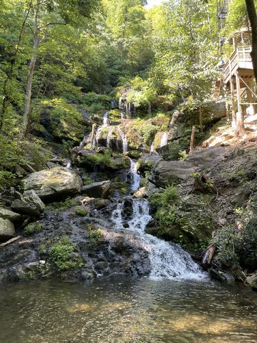
The Catawba Falls Trail at Pisgah National Forest near Old Fort, North Carolina is a moderate 2.9-mile out-and-back hike that leads to the ~100-foot tall waterfall, Catawba Falls.

Hike
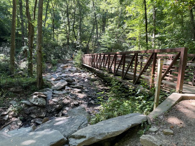
One of the most popular waterfall hikes in North Carolina, this hike is relatively easy, but has some altitude gain in the last half mile where the trail leaves the wide gravel path and becomes a narrower dirt trail. The waterfall is a set of two spectacular cascading falls, and a new stair system (as of 2024) had made the upper falls much easier to navigate. The upper falls cascades in a free-fall with lower falls consisting of multiple tiers to make up the total ~100-foot height. Be prepared for the crowds! This hike has a negative solitude rating!

Parking
Hikers will find a large parking lot at the end of Catawba River Road near Old Fort.

Pets
Dogs are allowed only if leashed and should be cleaned up after.

Explore 1 trail near Old Fort, NC
  1. Parking

    35.61372, -82.230214
  2. Main Trailhead

    35.613213, -82.230874
  3. Catawba Falls

    35.604439, -82.245025
    Catawba Falls
  4. Footbridge near Chestnut Branch

    35.605664, -82.245056
    Footbridge near Chestnut Branch
No community routes found. To add your own hike as a Community Route for this Trail guide, leave a Trip Report with an attached GPX file.

Hazards

Rockfalls / Ledges / or Scrambles

Seasons

All

Photo Albums

1 Trip Report

No Star-Ratings
Trail Guide By:
AuzzieHiker user profile picture
2.9 miles / 4.7 km
Trail added
July 07, 2024
Hiked on
July 07, 2024
Updated on
July 07, 2024

Weather Forecast

In Old Fort, NC

Explore Hiking Trails

New Hikes

Lake Estes Trail
0.9 Miles
1.4 km
Easy
Out-and-Back
Hidden Valley Nature Trail
0.7 Miles
1.1 km
Easy
Loop
Many Parks Curve Trail
0.4 Miles
0.6 km
Easy
Out-and-Back
Bierstadt Lake via Bierstadt Moraine Trail
3.4 Miles
5.5 km
Moderate
Out-and-Back

Before you boogie...

Find our trail guides useful? Consider becoming a Supporter to unlock perks!

MyHikes is an indie platform that makes exploring public trails easier for everyone. The platform has no investors, runs no ads, and is owned and operated by one person, Dave Miller. Dave has personally mapped and written over 1,600 trail guides on MyHikes for the public to explore. As of 2024, MyHikes has helped over 1,300,000 outdoor enthusiasts plan their next adventure.

But it takes a lot of time 🕦, money 💰, and work, and espresso shots ☕ to run MyHikes, including hiking , mapping , writing , and publishing new trails with high-quality (accurate) information... along with software engineering (coding) the platform like building new features, site and mobile app development for iOS and Android, site maintainance . and much much more.

Supporters unlock website and mobile app perks with an annual one-time payment of $25 (you renew) 😎👍. Or you can simply make a Donation of your choice. Otherwise, you can support us by telling your friends about MyHikes - both quick and free 🎉

Admin user profile picture

Dave Miller
MyHikes Founder