Loading...

🌲 WINTER SALE! 50% OFF on Supporter Accounts — now through December 31st. Unlock a full year of exclusive website & app perks for better hikes. Learn More.

Castel Montani Ruins Hike

Directions
Map
Pictures
Send to App
Distance:
1.3 km / 0.8 Miles
Type:
Out-and-Back
Difficulty:
Moderate
Time to Hike:
~24 minutes
Features:
Surface Type:
Dirt
Town:
Laces, Italy
Get Directions:
46.600227, 10.828012
Added:
September 22, 2025
Updated:
November 19, 2025
Copy Trail Link Hiking this trail? Send a friend or family member a link to this trail guide for your own safety. Hike at your own risk (disclaimer)
Loading...
Loading...
86m

Total Change
94m

Ascent
94m

Descent

Download the Trail Route for Offline Use

Supporters get exclusive access to download trail routes to the MyHikes app for offline use. Stay prepared on your adventure, even without an internet connection! Become a Supporter today to unlock this feature and hike with confidence.

Send to App

Key Takeaways

  • Explore the abandoned medieval fortresses of Castel Montani di Sopra (Obermontani) and Castel Montani di Sotto (Untermontani) on a single loop near Laces (Latsch), Italy.
  • Located in the heart of South Tyrol, this ridge trail offers spectacular south-facing views of the Italian Alps, the Plima waterfall, and the lush vineyards of Val Venosta.
  • While the upper castle is viewed from the outside, this trail allows you to safely step inside the crumbling walls of the lower castle ruins to see historic masonry and open-air windows.

Castel Montani Ruins Hike

Looking for a fun castle ruins hike in the Italian Alps of South Tyrol near Laces (Latsch), Italy? Look no further than the abandoned ruins of Castel Montani di Sopra and Castel Montani di Sotto!

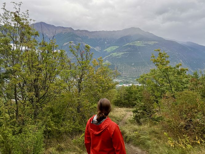
This fun, but moderate family-friendly hike leads visitors to two castle ruins along a mountain ridge in the heart of Val Venosta in the Italian Alps. Surrounded by vineyards, apple orchards, and towering alpine mountains, this short 1.3 km (0.8 mile) out-and-back hike features breathtaking Alps views and a chance to explore two distinct medieval fortifications.

Reaching Castel Montani di Sopra Ruins (Burg Obermontani)

The hike begins on a hairpin turn of the road Via Montani di Sopra (Obermontaniweg). Here, you will find a gated entrance to the trail.

After passing the gate, the first set of ruins presents itself almost immediately. Located just 50 meters from the trailhead, the abandoned tower of Castel Montani di Sopra (German: Burg Obermontani) stands tall overhead. The trail runs along the exterior of the castle walls, offering stunning south-facing views of the Italian Alps and the vineyard-filled valley below. To the east, hikers will find more views of the orchard and vineyard-filled valley that sits below the Italian Alps of South Tyrol.

Note: While Montani di Sopra is a unique fortress, the interior is gated. Visitors cannot enter these specific ruins, but you can admire the historic castle from the path.

The Descent to Castel Montani di Sotto (Burg Untermontani)

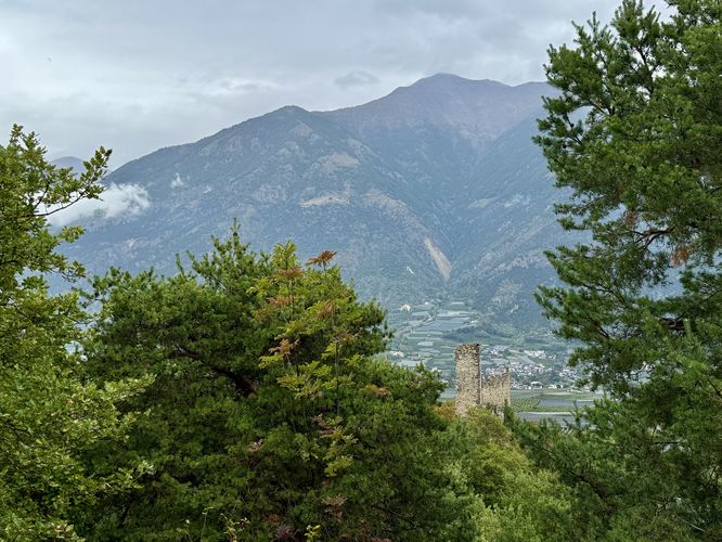
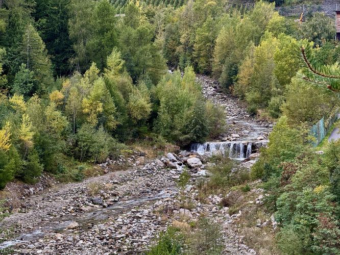
After exploring the exterior of the upper castle, the trail curves around the fortress and begins a descent along the mountain ridge toward the second ruin: Castel Montani di Sotto.

The path leads into the forest, following switchbacks downhill. Along the way, you are treated to panoramic views of South Tyrol’s dramatic landscape. To the southwest, look for the Rio Plima (Plimabach), where a ~3 meter (10 ft) waterfall cascades into the gorge below.

At approximately the 0.63 km mark, you will reach the entrance to Castel Montani di Sotto (German: Burg Untermontani).

Exploring the Castel Montani di Sotto Ruins

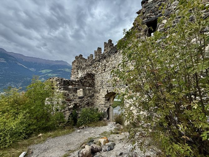
Unlike the first castle, Montani di Sotto is more accessible. A small path winds up and around the long-abandoned castle drawbridge that once connected the ridge to the fortress entrance.

Pass through the stone doorway to step into the long-gone interior of this castle ruin. Here, you will find historic walls, open windows framing the sky, and spectacular views.

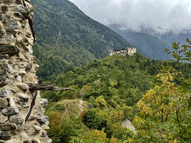
The view back uphill toward Castel Montani di Sopra is arguably the best on the hike. It frames the upper castle sitting on the ridge with the peaks of the Italian Alps in the background.

The Return Hike - 0.67 to 1.3 km

After exploring the interior of the abandoned Castel Montani di Sotto, the return hike is short but requires some effort. Follow the same path back up the mountain ridge. While the trail uphill is moderate, it offers a final chance to enjoy the scenic views of the orchard valley below with towering Italian Alps overhead.

Once you pass the upper castle again, exit through the gate to return to the road. Please remember to close the gate behind you.

Parking & Directions: How to Get to the Castel Montani Ruins

For visitors who are driving through the Italian Alps of South Tyrol near Laces (Latsch), Italy you won't want to miss this unique castle ruins hike. To find parking, there's a small parking turnout located near the trailhead located at the coordinates provided (46.600227, 10.828012) on Via Montani di Sopra (Obermontaniweg). Do not block the trail entrance and do not block the road!

Pets

Dogs are allowed only if leashed and must be cleaned up after.

Warning

Falling rock: Please note that these abandoned castle ruins are not renovated and as such, the castle walls (especially of Castel Montani di Sotto) are crumbling. The loose rock in the abandoned castle walls could fall at any time, so be aware of the dangers.
Explore 1 trail near Laces, Italy
  1. Parking

    46.600227, 10.828012
  2. Main Trailhead

    46.600289, 10.828066
  3. View of the Italian Alps in South Tyrol

    46.600708, 10.827784
    View of the Italian Alps in South Tyrol
  4. Castel Montani di Sopra

    46.600658, 10.827733
    Castel Montani di Sopra
  5. View of the Italian Alps of South Tyrol from the trail

    46.601453, 10.827633
    View of the Italian Alps of South Tyrol from the trail
  6. View of Castle Montani di Sotto from the trail

    46.603086, 10.827772
    View of Castle Montani di Sotto from the trail
  7. Stunning Italian Alps view on the trail to Castel Montani di Sotto

    46.603972, 10.827619
    Stunning Italian Alps view on the trail to Castel Montani di Sotto
  8. View of Castel Montani di Sopra from Castel Montani di Sotto

    46.60461, 10.827443
    View of Castel Montani di Sopra from Castel Montani di Sotto
  9. Inside the castle ruins of Montani di Sotto

    46.604647, 10.827428
    Inside the castle ruins of Montani di Sotto
  10. Rio Plima / Plimabach waterfall viewpoiint

    46.603233, 10.827447
    Rio Plima / Plimabach waterfall viewpoiint
No community routes found. To add your own hike as a Community Route for this Trail guide, leave a Trip Report with an attached GPX file.

Hazards

Rockfalls / Ledges / or Scrambles

Seasons

All

Photo Albums

+ Add Photo Album

Upload your photos from the trail to help others know what to expect.

Preview of the MyHikes mobile app interface

Track, Log, and Explore Hikes with the MyHikes App

Shop Landscape Prints
Shop our Alps landscape prints to support MyHikes!

Trip Reports (Reviews)

Ready to help fellow hikers? Add a trip report to share your experience and provide valuable insights for those planning their next hike. Your review makes the trail better for everyone.

Rated 5.0 out of 5 based on 1 rating.
0.8 miles / 1.3 km
September 22, 2025
Really fun and secluded hike with great views of the vineyards. The castle ruins were a lot of fun to explore and we only saw one other couple that hiked up the road to reach the castles. Highly recommend if driving through the valley.
Hiking

Explore Hiking Trails

You May Also Like

Colorado's Million Dollar Highway - Plan a day's drive adventure along the iconic Million Dollar Highway in Colorado. Explore the best short trails, roadside stops, waterfalls, vistas, ghost towns, and hot springs within a ~6 hour road trip.
Explore

Colorado's Million Dollar Highway

Plan a day's drive adventure along the iconic Million Dollar Highway in Colorado. Explore the best short trails, roadside stops, waterfalls, vistas, ghost towns, and hot springs within a ~6 hour road trip.

Read
Glacier's Going-to-the-Sun Road - Discover the breathtaking beauty of Glacier National Park along the iconic Going-to-the-Sun Road. From stunning roadside stops to picturesque waterfalls and vistas, this engineering marvel offers endless opportunities for exploration.
Explore

Glacier's Going-to-the-Sun Road

Discover the breathtaking beauty of Glacier National Park along the iconic Going-to-the-Sun Road. From stunning roadside stops to picturesque waterfalls and vistas, this engineering marvel offers endless opportunities for exploration.

Read
New York's Best Waterfalls - Whether you're planning a day hike, roadside stop, or a leisurely short walk, this guide provides hikers, travelers, and locals alike with 63 different locations to over 100 scenic waterfalls to help plan your next adventure!
Explore

New York's Best Waterfalls

Whether you're planning a day hike, roadside stop, or a leisurely short walk, this guide provides hikers, travelers, and locals alike with 63 different locations to over 100 scenic waterfalls to help plan your next adventure!

Read

Before you boogie...

Find our trail guides useful? Consider becoming a Supporter to unlock perks!

MyHikes is an indie platform that makes exploring public trails easier for everyone. The platform has no investors, no ads, and is owned and operated by one person, Dave Miller. Dave has personally mapped and written over 1,800 trail guides on MyHikes for the public to explore. MyHikes has helped millions outdoor enthusiasts plan their next adventure.

But it takes a lot of time 🕦, money 💰, work, and espresso shots ☕ to run MyHikes, including hiking , mapping , writing , and publishing new trails with high-quality (accurate) information... along with software engineering (coding) the platform like building new features, website and mobile app development (iOS and Android), site maintainance . and much much more.

Supporters unlock website and mobile app perks with an annual one-time payment of $25 (you renew) 😎👍. Or you can simply make a Donation of your choice. Otherwise, you can support us by telling your friends about MyHikes - both quick and free 🎉

Admin avatar

Dave Miller
MyHikes Founder
🍪 We use cookies to learn about site usage, performance, and to serve map tiles. You may block cookies manually in the browser. By continuing to use MyHikes, you agree. Learn more