Loading...

🌲 WINTER SALE! 50% OFF on Supporter Accounts — now through December 31st. Unlock a full year of exclusive website & app perks for better hikes. Learn More.

Cascate dell'Acquafraggia

Directions
Map
Pictures
Send to App
Distance:
0.2 km / 0.1 Miles
Type:
Out-and-Back
Difficulty:
Easy
Time to Hike:
~5 minutes
Features:
Surface Type:
Dirt
Town:
Borgonuovo, Italy
Get Directions:
46.330236, 9.438061
Added:
September 22, 2025
Updated:
November 18, 2025
Copy Trail Link Hiking this trail? Send a friend or family member a link to this trail guide for your own safety. Hike at your own risk (disclaimer)
Loading...
Loading...
2m

Total Change
2m

Ascent
2m

Descent

Download the Trail Route for Offline Use

Supporters get exclusive access to download trail routes to the MyHikes app for offline use. Stay prepared on your adventure, even without an internet connection! Become a Supporter today to unlock this feature and hike with confidence.

Send to App

Key Takeaways

  • The main viewpoint path to the base of the massive 140m waterfall in Borgonuovo (Sondrio), Italy is a super short, universally-accessible easy walk perfect for families and wheelchair access.
  • Visitors must drive to Borgonuovo, Italy, and use the public lot near coordinates 46.330236, 9.438061. Parking requires a small hourly € fee paid at the station.
  • This natural landmark features a seasonal stream, and visitors should expect the waterfall's intense spray (regardless of rain) and note that leashed dogs are allowed on the trail.

Cascate dell'Acquafraggia

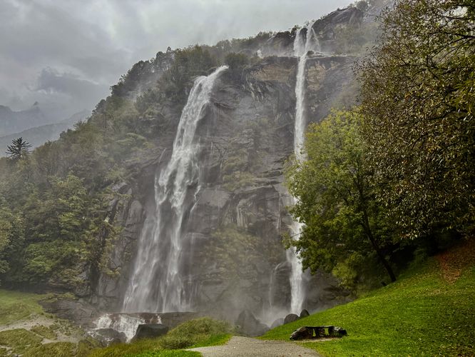
Looking to explore a massive waterfall in the southern Italian Alps near Borgonuovo (Sondrio), Italy? Look no further than the 140 meter (460 feet) tall waterfall, Cascate dell'Acquafraggia.

Cascate dell'Acquafraggia Trail Guide: Hike, Viewpoint & Parking in Borgonuovo, Italy

Located in the heart of Borgonuovo, Italy (in the Province of Sondrio) and seen from all around town is the massive two-tier Italian Alps waterfall known as Cascate dell'Acquafraggia (Waterfall Acquafraggia). This short, flat, and universally-accessible easy walk leads visitors along a path to the base of the waterfall where you can enjoy the breathtaking plunge of the seasonal stream, Acquafraggia. The total length of the walk is approximately 0.23 km or 0.1 mile out-and-back. If you wish to explore further, by hiking up nearby trails to reach the upper tier, the length to explore this waterfall will be much longer and more difficult, however, most visitors only care to explore Cascate dell'Acquafraggia from its base.

The Massive Cascate dell'Acquafraggia Waterfall

While visitors do not need to walk very far, this super short path leads from the parking area to the base of the cascade where you'll find breathtaking views of the 140m (460 feet) tall Italian Alps waterfall. The path that leads to the base of Acquafraggia Falls is comprised of crushed stone and is mostly flat—perfect for a small children or even wheelchair access.
During our visit in mid-September 2025, the weather had heavy rain, so I didn't make it all the way to the base of the waterfall as my camera lens was too wet to continue, but I was able to enjoy the massive waterfall from the trail near the base of the cascade. If you visit on a nice day, the waterfall's spray will likely get you wet regardless if it's raining or not!

Parking & Directions to Cascate dell'Acquafraggia in Borgonuovo

Visiting the waterfall will require driving into Borgonuovo, Italy where you'll find several public parking lots. The parking coordinates for this guide (46.330236, 9.438061) lead you directly to a parking lot across the street from the trailhead. At the parking lot, there's a small hourly fee to park. Visitors can pay using the pay station at the parking lot.

Fees

Aside from parking fees, the sign states that the park requires a €3 entrance fee; however, when we visited there were no pay stations or people collecting the fee at the trailhead. Parking does require a small hourly fee, however.

Universal Access

The walk to reach Cascate dell'Acquafraggia follows an easy, universally-accessible path. The walk to the waterfall is family-friendly and wheelchair accessible as of September 2025.

Pets

Dogs are allowed only if leashed and must be cleaned up after.
Explore 6 trails near Borgonuovo, Italy
  1. Parking

    46.330236, 9.438061
  2. Main Trailhead

    46.330236, 9.438061
  3. Cascate dell'Acquafraggia (Cascade Acquafraggia)

    46.330877, 9.437471
    Cascate dell'Acquafraggia (Cascade Acquafraggia)
No community routes found. To add your own hike as a Community Route for this Trail guide, leave a Trip Report with an attached GPX file.

Hazards

Rockfalls / Ledges / or Scrambles

Seasons

All

Photo Albums

+ Add Photo Album

Upload your photos from the trail to help others know what to expect.

Preview of the MyHikes mobile app interface

Track, Log, and Explore Hikes with the MyHikes App

Shop Landscape Prints
Shop our Alps landscape prints to support MyHikes!

Trip Reports (Reviews)

Ready to help fellow hikers? Add a trip report to share your experience and provide valuable insights for those planning their next hike. Your review makes the trail better for everyone.

Your opinion matters! Be the first to rate this trail.

Explore Hiking Trails

You May Also Like

Colorado's Million Dollar Highway - Plan a day's drive adventure along the iconic Million Dollar Highway in Colorado. Explore the best short trails, roadside stops, waterfalls, vistas, ghost towns, and hot springs within a ~6 hour road trip.
Explore

Colorado's Million Dollar Highway

Plan a day's drive adventure along the iconic Million Dollar Highway in Colorado. Explore the best short trails, roadside stops, waterfalls, vistas, ghost towns, and hot springs within a ~6 hour road trip.

Read
Glacier's Going-to-the-Sun Road - Discover the breathtaking beauty of Glacier National Park along the iconic Going-to-the-Sun Road. From stunning roadside stops to picturesque waterfalls and vistas, this engineering marvel offers endless opportunities for exploration.
Explore

Glacier's Going-to-the-Sun Road

Discover the breathtaking beauty of Glacier National Park along the iconic Going-to-the-Sun Road. From stunning roadside stops to picturesque waterfalls and vistas, this engineering marvel offers endless opportunities for exploration.

Read
New York's Best Waterfalls - Whether you're planning a day hike, roadside stop, or a leisurely short walk, this guide provides hikers, travelers, and locals alike with 63 different locations to over 100 scenic waterfalls to help plan your next adventure!
Explore

New York's Best Waterfalls

Whether you're planning a day hike, roadside stop, or a leisurely short walk, this guide provides hikers, travelers, and locals alike with 63 different locations to over 100 scenic waterfalls to help plan your next adventure!

Read

Before you boogie...

Find our trail guides useful? Consider becoming a Supporter to unlock perks!

MyHikes is an indie platform that makes exploring public trails easier for everyone. The platform has no investors, no ads, and is owned and operated by one person, Dave Miller. Dave has personally mapped and written over 1,800 trail guides on MyHikes for the public to explore. MyHikes has helped millions outdoor enthusiasts plan their next adventure.

But it takes a lot of time 🕦, money 💰, work, and espresso shots ☕ to run MyHikes, including hiking , mapping , writing , and publishing new trails with high-quality (accurate) information... along with software engineering (coding) the platform like building new features, website and mobile app development (iOS and Android), site maintainance . and much much more.

Supporters unlock website and mobile app perks with an annual one-time payment of $25 (you renew) 😎👍. Or you can simply make a Donation of your choice. Otherwise, you can support us by telling your friends about MyHikes - both quick and free 🎉

Admin avatar

Dave Miller
MyHikes Founder
🍪 We use cookies to learn about site usage, performance, and to serve map tiles. You may block cookies manually in the browser. By continuing to use MyHikes, you agree. Learn more