The Cascadilla Gorge Trail in Ithaca, New York is a popular and moderate 1.2-mile out-and-back hike that features 8 different waterfalls ranging from 7-feet tall to about 40-feet or more.
Park
This trail and the natural area are maintained by the Cornell Botanic Gardens.
Hike Description
This scenic gorge hike begins at the western terminus for the Cascadilla Gorge Trail and follows the main path as it meanders its way up the gorge. Along the way are a plethora of different waterfalls to enjoy, but some of the most scenic are near the eastern end of the trail. Hikers will find a trailhead kiosk with information and a trail map; however, the data (mileage) on the map is very wrong, stating that this trail is just 0.3-miles long one-way.
10-foot Waterfall - Mile 0.1
Within the first tenth of a mile, hikers will reach the waterfall that starts the hike. This waterfall cascades down the gorge at about 10-feet tall.
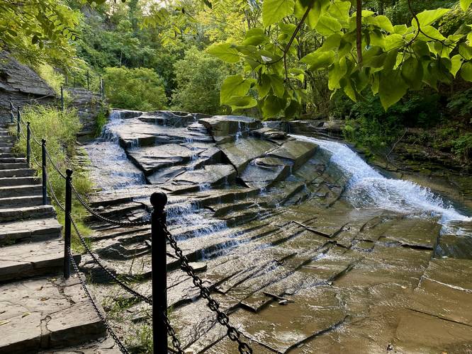
25-foot Waterfall - Mile 0.16
Just around the creek bend sits a multi-tiered waterfall that cascades down the gorge at about 25-feet in total; however it's broken up into several different cascades. Hikers can get a nice view of the bottom tiers of the cascade as they come around the large bend. Right as the stairs begin to climb, you'll get better views of the larger portion of the waterfall, albeit sometimes obstructed by trees slightly.
7-foot Waterfall - Mile 0.2
Around mile 0.2, hikers will pass a short, but scenic 7-foot waterfall.
Waterfall & Footbridge View - Mile 0.26
Around mile 0.26, hikers will reach a scenic view along the trail of the stone footbridge and waterfall rushing below.
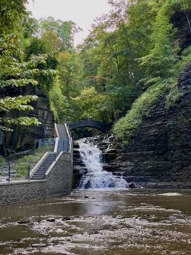
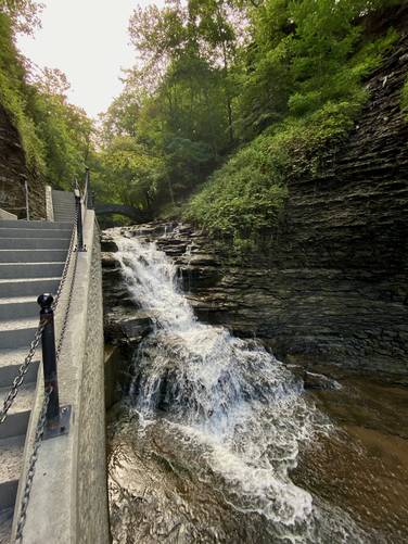
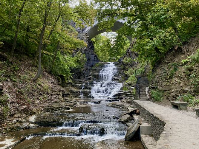
30-foot Waterfall & Footbridge - Mile 0.3
Around mile 0.3, hikers will walk adjacent to the 30-foot cascade and then pass over the stone footbridge to make their way up the trail.
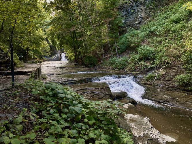
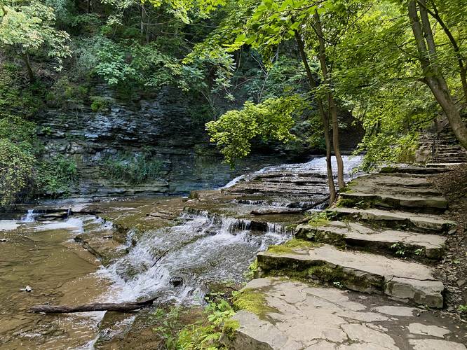
15-foot Waterfall - Mile 0.35
After the stone footbridge, the trail will bend around the creek once more where hikers will find a ~15-foot multi-tiered waterfall.
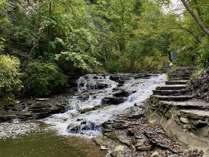
8-foot Waterfall - Mile 0.42
Around mile 0.42, another waterfall will pop up around the bend in the creek - this one is about 8-feet tall.
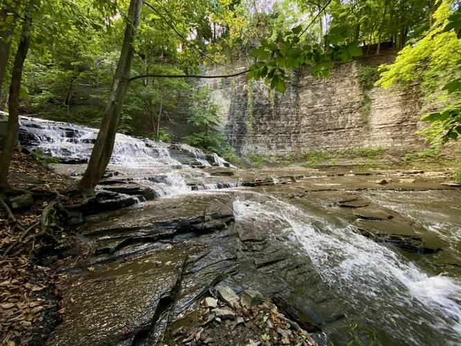
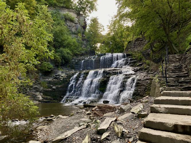
40-foot Waterfall - mile 0.45
One of the largest waterfalls along the hike sits around mile 0.45 and cascades down two different tiers of sandstone bedrock to form a 40-foot waterfall.
30-foot Waterfall / Last Waterfall - mile 0.5
At mile 0.5, hikers will reach the last waterfall along this trail, which cascades down the gorge at about 30-feet tall.
After passing the last cascade, hikers will head up the stairs to reach the top of the gorge. The trail ends at College Ave where you can continue exploring the gorge along the Upper Cascadilla Gorge Trail.
Parking & Fees
Hikers will find street parking nearby at the coordinates provided. Street parking has a fee during weekdays - pay at the parking space meter.
Pets
Dogs are allowed if leashed and must be cleaned up after.
Warning
Falling rock: This trail follows a gorge made-up of sandstone and shale. Both rock types tend to fall and cause debris fields - stay away from rock ledges to ensure your own safety from falling rock.
Park
This trail and the natural area are maintained by the Cornell Botanic Gardens.
Hike Description
This scenic gorge hike begins at the western terminus for the Cascadilla Gorge Trail and follows the main path as it meanders its way up the gorge. Along the way are a plethora of different waterfalls to enjoy, but some of the most scenic are near the eastern end of the trail. Hikers will find a trailhead kiosk with information and a trail map; however, the data (mileage) on the map is very wrong, stating that this trail is just 0.3-miles long one-way.
10-foot Waterfall - Mile 0.1
Within the first tenth of a mile, hikers will reach the waterfall that starts the hike. This waterfall cascades down the gorge at about 10-feet tall.
25-foot Waterfall - Mile 0.16
Just around the creek bend sits a multi-tiered waterfall that cascades down the gorge at about 25-feet in total; however it's broken up into several different cascades. Hikers can get a nice view of the bottom tiers of the cascade as they come around the large bend. Right as the stairs begin to climb, you'll get better views of the larger portion of the waterfall, albeit sometimes obstructed by trees slightly.
7-foot Waterfall - Mile 0.2
Around mile 0.2, hikers will pass a short, but scenic 7-foot waterfall.
Waterfall & Footbridge View - Mile 0.26
Around mile 0.26, hikers will reach a scenic view along the trail of the stone footbridge and waterfall rushing below.
30-foot Waterfall & Footbridge - Mile 0.3
Around mile 0.3, hikers will walk adjacent to the 30-foot cascade and then pass over the stone footbridge to make their way up the trail.
15-foot Waterfall - Mile 0.35
After the stone footbridge, the trail will bend around the creek once more where hikers will find a ~15-foot multi-tiered waterfall.
8-foot Waterfall - Mile 0.42
Around mile 0.42, another waterfall will pop up around the bend in the creek - this one is about 8-feet tall.
40-foot Waterfall - mile 0.45
One of the largest waterfalls along the hike sits around mile 0.45 and cascades down two different tiers of sandstone bedrock to form a 40-foot waterfall.
30-foot Waterfall / Last Waterfall - mile 0.5
At mile 0.5, hikers will reach the last waterfall along this trail, which cascades down the gorge at about 30-feet tall.
After passing the last cascade, hikers will head up the stairs to reach the top of the gorge. The trail ends at College Ave where you can continue exploring the gorge along the Upper Cascadilla Gorge Trail.
Parking & Fees
Hikers will find street parking nearby at the coordinates provided. Street parking has a fee during weekdays - pay at the parking space meter.
Pets
Dogs are allowed if leashed and must be cleaned up after.
Warning
Falling rock: This trail follows a gorge made-up of sandstone and shale. Both rock types tend to fall and cause debris fields - stay away from rock ledges to ensure your own safety from falling rock.