Loading...

🎆 50%-off 4th of July sale on Supporter Accounts thru July 6th! Learn more

Carvin Cove and Hay Rock Hike

Directions
Map
Pictures
Send to App
Distance:
7.7 Miles / 12.4 km
Type:
Out-and-Back
Difficulty:
Moderate
Time to Hike:
3 hours, ~51 minutes
Features:
Appalachian Trail hike
Surface Type:
Dirt
Park:
Jefferson National Forest
Town:
Daleville, Virginia
Directions:
37.39086, -79.906203
Added:
February 28, 2025
Updated:
April 05, 2025
Copy Trail Link Hiking this trail? Send a friend or family member a link to this trail guide for your own safety. Hike at your own risk (disclaimer)
Loading...
Loading...
833'

Total Change
1,612'

Ascent
1,606'

Descent

Download the Trail Route for Offline Use

Supporters get exclusive access to download trail routes to the MyHikes app for offline use. Stay prepared on your adventure, even without an internet connection! Become a Supporter today to unlock this feature and hike with confidence.

Send to App

Carvin Cove and Hay Rock Hike

Are you tired of ridgeline hikes that have beautiful views of trees? If so, then head to Daleville, VA and go south on the A.T. for view after view of the Carvin Cove Reservoir below and mountains beyond. We marked 3 great overlooks but there are many more before finally reaching Hay Rock.

The climb to the ridgeline is about 2 miles. We last did this hike in late June, and can only imagine what this hike will be like in the Fall. You may need more time with all the stops to take in the views :)

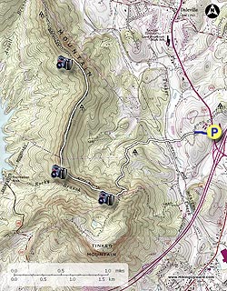
The trail begins at the guard rail behind the commuter parking area. There is room for 3-4 cars to park in front of the guard rail.

  • Mile 0.0 – Cross the road to the guard rail and continue 0.2 miles on the unmarked trail until you reach the A.T. Intersection.

  • Mile 0.2 – At the A.T. intersection bear left onto the white blazed A.T. In the next 0.9 miles you will cross a creek and railroad tracks before reaching the RATC Information Kiosk.

  • Mile 1.1 – RATC Information Kiosk. An easy hike to this point and we were beginning to wonder what happened to those lovely rocks we have come to expect on the A.T. in VA, should have kept our thoughts to ourselves!! From this point it becomes steeper and the trail more rocky.

  • Mile 1.9 – Cross under a high voltage power line, and you'll cross this once again on the ridge. There are a few switchbacks prior to reaching the ridge at the 1.9 mile mark, passing under another high voltage power line. The power lines took away from some of the beauty of this hike, but the views will make you forget them. The view to the northeast is Daleville.

  • Mile 4.0 – Over the next 0.8 miles we marked 3 (there are others) really good overlooks with views to the west of McAfee Knob before finally reaching Hay Rock. There is a little bit of a climb to get to the best view on Hay Rock accessed via the crevice near the north side. Please be careful as it is steep to get to the top. This section is not advised for small children. Some of the previous overlooks are better suited for lunch than Hay Rock.

  • Mile 7.7 – Enjoy your time here then retrace your steps back to the parking area on Route US220.
Explore 17 trails near Daleville, VA
  1. Parking

    37.39086, -79.906203
  2. Main Trailhead

    37.391139, -79.906526
No community routes found. To add your own hike as a Community Route for this Trail guide, leave a Trip Report with an attached GPX file.

Hazards

Ticks - Lyme Disease More Info (CDC)
Snakes
Poison Ivy/Oak

Seasons

All

Blaze Color

White

Trip Reports

Trail Guide By:
HikingUpward user profile picture
7.7 miles / 12.4 km

Weather Forecast

In Daleville, VA

Explore Hiking Trails

You May Also Like

New York's Best Waterfalls - Whether you're planning a day hike, roadside stop, or a leisurely short walk, this guide provides hikers, travelers, and locals alike with 63 different locations to over 100 scenic waterfalls to help plan your next adventure!
Explore

New York's Best Waterfalls

Whether you're planning a day hike, roadside stop, or a leisurely short walk, this guide provides hikers, travelers, and locals alike with 63 different locations to over 100 scenic waterfalls to help plan your next adventure!

Read
25 Best Day Hikes in North Carolina - Discover the top 25 best day hikes in North Carolina, from breathtaking waterfalls to mountain peaks. Explore hidden gems, scenic views, and trails suitable for all skill levels, perfect for your next outdoor adventure.
Explore

25 Best Day Hikes in North Carolina

Discover the top 25 best day hikes in North Carolina, from breathtaking waterfalls to mountain peaks. Explore hidden gems, scenic views, and trails suitable for all skill levels, perfect for your next outdoor adventure.

Read

Before you boogie...

Find our trail guides useful? Consider becoming a Supporter to unlock perks!

MyHikes is an indie platform that makes exploring public trails easier for everyone. The platform has no investors, no ads, and is owned and operated by one person, Dave Miller. Dave has personally mapped and written over 1,800 trail guides on MyHikes for the public to explore. MyHikes has helped millions outdoor enthusiasts plan their next adventure.

But it takes a lot of time 🕦, money 💰, work, and espresso shots ☕ to run MyHikes, including hiking , mapping , writing , and publishing new trails with high-quality (accurate) information... along with software engineering (coding) the platform like building new features, website and mobile app development (iOS and Android), site maintainance . and much much more.

Supporters unlock website and mobile app perks with an annual one-time payment of $25 (you renew) 😎👍. Or you can simply make a Donation of your choice. Otherwise, you can support us by telling your friends about MyHikes - both quick and free 🎉

Admin user profile picture

Dave Miller
MyHikes Founder