Loading...

WINTER SALE! 50% OFF Supporter Accounts — now through January 31st. Learn More.

Capitol Reef Scenic Vista

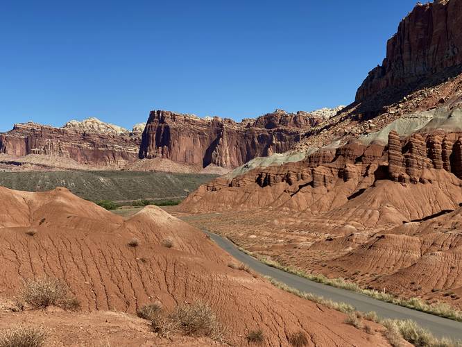
Capitol Reef Scenic Vista at Capitol Reef National Park in Wayne County, Utah is an easy 0.1-mile out-and-back walk that leads to a scenic view of the Waterpocket Fold from the Capitol Reef Scenic Drive.

This is not a hike but rather a very short walk from a parking turnout and out to a scenic overlook that peers north through the valley toward Fruita, Utah. The views surrounding the scenic drive are stunning and steep rock ledges with large mesas that stretch for miles upon miles.

Parking
Hikers will find a small parking turnout at the coordinates provided, located on the western side of Capitol Reef Scenic Drive.

Pets
Dogs are not allowed on this trail.
Explore 20 trails near Wayne County, UT

Know Before You Go

  • Short, accessible walk to a scenic overlook.
  • Located along Capitol Reef Scenic Drive with views of the Waterpocket Fold and Fruita area.
  • Dogs are prohibited.
Interactive topographic map for Capitol Reef Scenic Vista located in Wayne County, UT. Click the "View Map" button to load GPS coordinates and trail markers.
Get directions
Distance
0.1 mi
Difficulty
Easy
Type
Out-and-Back
Est. Time
5 min
Elev. Gain
8'
Rating
0.0
Added
September 28, 2023
Updated
October 04, 2023

Weather Forecast

Loading...
Total Change
7'
Ascent
8'
Descent
8'
Loading...

Download the GPX Data for Offline Use

Supporters get exclusive access to download trail routes to the MyHikes app for offline use. Stay prepared on your adventure, even without an internet connection! Become a Supporter today to unlock this feature and hike with confidence.

Download Capitol Reef Scenic Vista GPX Data to the MyHikes Mobile App

Features

Vista / Lookout Point

Points of interest

  1. Parking

    38.266841, -111.244962
  2. Main Trailhead

    38.266935, -111.245062

Safety information

For your own safety: plan ahead, let someone know where you'll be, and hike at your own risk.

Hazards

Snakes (Rattlesnakes, Copperheads, others)

Availability

All seasons

Surface type

Dirt

Trip Reports (Reviews)

Your opinion matters! Be the first to rate this trail.

Ready to help fellow hikers? Add a trip report to share your experience and provide valuable insights for other hikers!

0.1 miles / 0.2 km
September 27, 2023
Hiking
No community routes found. To add your own hike as a Community Route for this Trail guide, leave a Trip Report with an attached GPX file.

Popular categories

Scenic mountain view representing vista trails
Vista trails
Scenic gorge of cascades representing waterfall trails
Waterfall hikes
Rugged mountain terrain representing summit trails
Summit trails
Scenic mountain view representing dog-friendly trails
Dog-friendly
Scenic campsite with a view representing camping trails
Camping trails
Appalachian Trail logo representing A.T. hikes
A.T. hikes

You May Also Like

Colorado's Million Dollar Highway - Plan a day's drive adventure along the iconic Million Dollar Highway in Colorado. Explore the best short trails, roadside stops, waterfalls, vistas, ghost towns, and hot springs within a ~6 hour road trip.
Explore

Colorado's Million Dollar Highway

Plan a day's drive adventure along the iconic Million Dollar Highway in Colorado. Explore the best short trails, roadside stops, waterfalls, vistas, ghost towns, and hot springs within a ~6 hour road trip.

Read
Glacier's Going-to-the-Sun Road - Discover the breathtaking beauty of Glacier National Park along the iconic Going-to-the-Sun Road. From stunning roadside stops to picturesque waterfalls and vistas, this engineering marvel offers endless opportunities for exploration.
Explore

Glacier's Going-to-the-Sun Road

Discover the breathtaking beauty of Glacier National Park along the iconic Going-to-the-Sun Road. From stunning roadside stops to picturesque waterfalls and vistas, this engineering marvel offers endless opportunities for exploration.

Read
🍪 We use cookies to learn about site usage and to serve map tiles. You may block cookies manually in the browser. By continuing you agree. Learn more