Loading...

WINTER SALE! 50% OFF Supporter Accounts — now through January 31st. Learn More.

Capitol Reef Petroglyphs

The Capitol Reef Petroglyphs at Capitol Reef National Park in Fruita, Utah is an easy 0.3-mile universally-accessible out-and-back trail that features two sets of ancient Native American petroglyphs.

Walk Description
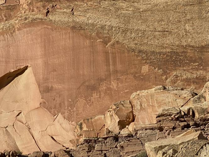
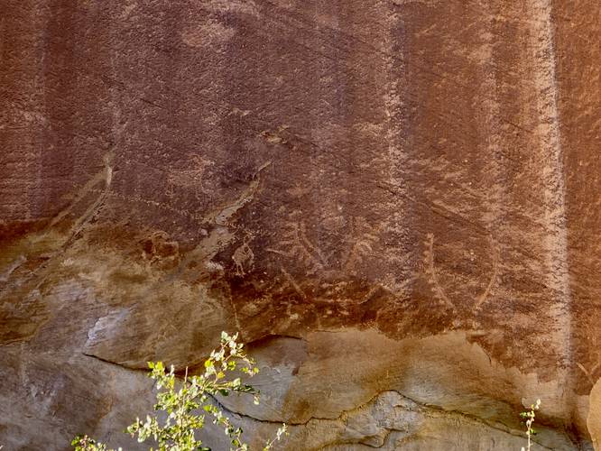
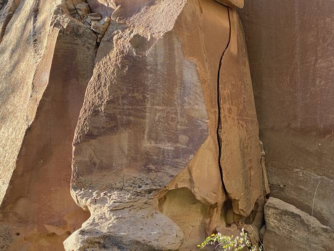
This is not a hike but rather a short walk along a universally-accessible boardwalk trail that leads to two different sets of petroglyphs. First, hikers will head along the shortest path which leads north from the parking lot and ends within 150-feet or so where they'll find petroglyphs located high on the rock wall above their heads. After exploring the norther-most petroglyphs, hikers can head east along the paved pathway and over to the eastern boardwalk. From the eastern boardwalk, hikers can head to the end of the trail where they'll find more ancient petroglyphs in addition to some newer illegal graffiti that was carved into the rock.

Parking
Hikers will find a large paved parking lot at the coordinates provided.

Pets
Dogs are not allowed on this trail.

Warning
Falling rock: Despite the trail being far from the cliff's edge, sometimes rockfalls can happen along these sheer rock ledges. Rockfalls are rare.
Explore 20 trails near Fruita, UT

Know Before You Go

  • The Capitol Reef Petroglyphs trail is a short, universally-accessible walk to view ancient Native American rock art.
  • The trail features two distinct sets of petroglyphs, one located north of the parking lot and another further east along a boardwalk.
  • Dogs are prohibited on the trail, and visitors should be aware of the potential (though rare) for falling rocks.
Interactive topographic map for Capitol Reef Petroglyphs located in Fruita, UT. Click the "View Map" button to load GPS coordinates and trail markers.
Get directions
Distance
0.3 mi
Difficulty
Easy
Type
Out-and-Back
Est. Time
9 min
Elev. Gain
15'
Rating
0.0
Added
September 26, 2023
Updated
October 04, 2023

Weather Forecast

Loading...
Total Change
15'
Ascent
15'
Descent
15'
Loading...

Download the GPX Data for Offline Use

Supporters get exclusive access to download trail routes to the MyHikes app for offline use. Stay prepared on your adventure, even without an internet connection! Become a Supporter today to unlock this feature and hike with confidence.

Download Capitol Reef Petroglyphs GPX Data to the MyHikes Mobile App

Points of interest

  1. Parking

    38.288049, -111.242435
  2. Main Trailhead

    38.288137, -111.242446
  3. Capitol Reef Petroglyphs

    38.288433, -111.242394
    Capitol Reef Petroglyphs
  4. Capitol Reef Petroglyphs

    38.287856, -111.239926
    Capitol Reef Petroglyphs

Safety information

For your own safety: plan ahead, let someone know where you'll be, and hike at your own risk.

Hazards

Snakes (Rattlesnakes, Copperheads, others)

Availability

All seasons

Surface type

Universal Access

Trip Reports (Reviews)

Your opinion matters! Be the first to rate this trail.

Ready to help fellow hikers? Add a trip report to share your experience and provide valuable insights for other hikers!

0.3 miles / 0.5 km
September 26, 2023
Hiking
No community routes found. To add your own hike as a Community Route for this Trail guide, leave a Trip Report with an attached GPX file.

Popular categories

Scenic mountain view representing vista trails
Vista trails
Scenic gorge of cascades representing waterfall trails
Waterfall hikes
Rugged mountain terrain representing summit trails
Summit trails
Scenic mountain view representing dog-friendly trails
Dog-friendly
Scenic campsite with a view representing camping trails
Camping trails
Appalachian Trail logo representing A.T. hikes
A.T. hikes

You May Also Like

Colorado's Million Dollar Highway - Plan a day's drive adventure along the iconic Million Dollar Highway in Colorado. Explore the best short trails, roadside stops, waterfalls, vistas, ghost towns, and hot springs within a ~6 hour road trip.
Explore

Colorado's Million Dollar Highway

Plan a day's drive adventure along the iconic Million Dollar Highway in Colorado. Explore the best short trails, roadside stops, waterfalls, vistas, ghost towns, and hot springs within a ~6 hour road trip.

Read
Glacier's Going-to-the-Sun Road - Discover the breathtaking beauty of Glacier National Park along the iconic Going-to-the-Sun Road. From stunning roadside stops to picturesque waterfalls and vistas, this engineering marvel offers endless opportunities for exploration.
Explore

Glacier's Going-to-the-Sun Road

Discover the breathtaking beauty of Glacier National Park along the iconic Going-to-the-Sun Road. From stunning roadside stops to picturesque waterfalls and vistas, this engineering marvel offers endless opportunities for exploration.

Read
🍪 We use cookies to learn about site usage and to serve map tiles. You may block cookies manually in the browser. By continuing you agree. Learn more