Loading...

🎉 Enjoy a Free 7-Day Supporter Trial and Unlock Exclusive Perks — No Credit Card Required. Learn more.

Cacapon Resort State Park Hike

Directions
Map
Pictures
Send to App
Distance:
6.0 Miles / 9.7 km
Type:
Loop
Difficulty:
Moderate
Time to Hike:
3 hours
Features:
Surface Type:
Dirt
Town:
Berkeley Springs, West Virginia
Directions:
39.506177, -78.299716
Added:
March 20, 2025
Updated:
April 06, 2025
Copy Trail Link Hiking this trail? Send a friend or family member a link to this trail guide for your own safety. Hike at your own risk (disclaimer)
Loading...
Loading...
1,259'

Total Change
1,546'

Ascent
1,551'

Descent

Download the Trail Route for Offline Use

Supporters get exclusive access to download trail routes to the MyHikes app for offline use. Stay prepared on your adventure, even without an internet connection! Become a Supporter today to unlock this feature and hike with confidence.

Send to App

Cacapon Resort State Park Hike

Cacapon Resort State Park is a beautiful area of over 6,000 acres. There is something for everyone here. A virtual labyrinth of over 20 miles of hiking trails, a trap shooting range, horseback riding, swimming and boating, as well as fishing in the large lake and reservoir. The park also has accommodations of 24 cabins and a main inn for weekend getaways.

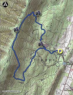
With 20 miles of interconnecting trails, from the easy nature walks, to the longer circuits that climb to the ridge on Cacapon Mountain, there are trails for every level of hiker. The circuit we describe makes use of the longer perimeter trails, and passes several good views of the valley.

From the lodge, walk back to the stop sign crossing the main road towards the cabins. The trailhead is located between cabins 21 and 22. Shortly after starting up the trail come to the first trail junction with the white blazed Cabin Loop Trail directly ahead. Turn right on the green blazed Laurel Trail, then in 150 yards pass the opposite end of the white blazed Cabin Loop Trail.

Continue straight on the green blazed Laurel Trail where it becomes steeper, before passing the red blazed central trail, and view of the reservoir on the right in 0.2 miles. Continue on the Laurel Trail for another 0.2 miles to the junction of the red blazed Central Trail at a small saddle.

Turn left downhill on the Central Trail then cross a park road in 0.1 miles. The red blazed trail continues on the opposite side of the road where it passes behind a group of cabins. After passing the cabins the trail climbs a small ridge before passing through an immature forest, then slightly descends and arrives at the Ziler Loop Trail intersection in 1.0 miles.

Turn right uphill on the red/blue blazed Ziler Loop Central Trail and come to the next intersection in 0.1 miles. At this intersection the combined Ziler Loop Central Trail turns right. Stay straight uphill on the blue blazed Ziler Loop Trail. The blue blazed trail has a steep grade with no switchbacks, leveling off only two times before arriving at the ridge and intersection of the Ziler Trail in 1.5 miles.

There is also a bench at the ridge and trail junction. Continue along the ridge on the Ziler Loop Trail passing an old shelter on the left before the Ziler Loop Trail begins to descend the mountain. The trail will make several switchbacks then pass through a hollow in 1.0 miles. Just after the hollow, the Ziler Loop Central Trail turns right. Continue straight on the now red blazed Central Trail and shortly cross a gravel park road.

The Central Trail continues on the other side of the road passing through an immature forest, then descends before crossing the next park road in another 0.5 miles. Follow the red blazed trail as it passes along the left of North Fork Run, just before crossing at the reservoir. The red blazed Central Trail will climb and reach the Laurel Trail in 0.2 miles. Turn left down the Laurel Trail passing the Cabin Loop Trail, and arriving back to the trailhead between cabins 21 and 22.
Explore 2 trails near Berkeley Springs, WV
  1. Parking

    39.506177, -78.299716
  2. Main Trailhead

    39.506077, -78.300462
No community routes found. To add your own hike as a Community Route for this Trail guide, leave a Trip Report with an attached GPX file.

Hazards

Ticks - Lyme Disease More Info (CDC)
Snakes
Poison Ivy/Oak

Seasons

All

Weather Forecast

In Berkeley Springs, WV

Explore Hiking Trails

You May Also Like

Colorado's Million Dollar Highway - Plan a day's drive adventure along the iconic Million Dollar Highway in Colorado. Explore the best short trails, roadside stops, waterfalls, vistas, ghost towns, and hot springs within a ~6 hour road trip.
Explore

Colorado's Million Dollar Highway

Plan a day's drive adventure along the iconic Million Dollar Highway in Colorado. Explore the best short trails, roadside stops, waterfalls, vistas, ghost towns, and hot springs within a ~6 hour road trip.

Read
New York's Best Waterfalls - Whether you're planning a day hike, roadside stop, or a leisurely short walk, this guide provides hikers, travelers, and locals alike with 63 different locations to over 100 scenic waterfalls to help plan your next adventure!
Explore

New York's Best Waterfalls

Whether you're planning a day hike, roadside stop, or a leisurely short walk, this guide provides hikers, travelers, and locals alike with 63 different locations to over 100 scenic waterfalls to help plan your next adventure!

Read

Before you boogie...

Find our trail guides useful? Consider becoming a Supporter to unlock perks!

MyHikes is an indie platform that makes exploring public trails easier for everyone. The platform has no investors, no ads, and is owned and operated by one person, Dave Miller. Dave has personally mapped and written over 1,800 trail guides on MyHikes for the public to explore. MyHikes has helped millions outdoor enthusiasts plan their next adventure.

But it takes a lot of time 🕦, money 💰, work, and espresso shots ☕ to run MyHikes, including hiking , mapping , writing , and publishing new trails with high-quality (accurate) information... along with software engineering (coding) the platform like building new features, website and mobile app development (iOS and Android), site maintainance . and much much more.

Supporters unlock website and mobile app perks with an annual one-time payment of $25 (you renew) 😎👍. Or you can simply make a Donation of your choice. Otherwise, you can support us by telling your friends about MyHikes - both quick and free 🎉

Admin user profile picture

Dave Miller
MyHikes Founder