Loading...

🎉 Enjoy a Free 7-Day Supporter Trial and Unlock Exclusive Perks — No Credit Card Required. Learn more.

C&O Canal and Weverton Cliff Hike

Directions
Map
Pictures
Send to App
Distance:
8.7 Miles / 14.0 km
Type:
Out-and-Back
Difficulty:
Hard
Time to Hike:
4 hours, ~21 minutes
Features:
Appalachian Trail hike
Surface Type:
Dirt
Park:
Harpers Ferry National Historical Park
Town:
Harpers Ferry, West Virginia
Directions:
39.324187, -77.730961
Added:
March 20, 2025
Updated:
April 06, 2025
Copy Trail Link Hiking this trail? Send a friend or family member a link to this trail guide for your own safety. Hike at your own risk (disclaimer)
Loading...
Loading...
611'

Total Change
821'

Ascent
821'

Descent

Download the Trail Route for Offline Use

Supporters get exclusive access to download trail routes to the MyHikes app for offline use. Stay prepared on your adventure, even without an internet connection! Become a Supporter today to unlock this feature and hike with confidence.

Send to App

C&O Canal and Weverton Cliff Hike

This a beautiful hike, but don't let the C&O Canal tow path walk lull you into thinking it's going to be easy. Look at the elevation profile and you'll see that after the nice walk on the C&O the remaining 1.5 miles to Weverton Cliff is a steep climb with multiple switch backs. The payoff is the beautiful view from Weverton Cliff and walk in Harpers Ferry.

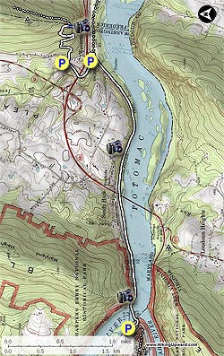
Starting in Harpers Ferry WV you cross the scenic footbridge over the Potomac River and walk along the C&O Canal tow path, get the heart pumping up to Weverton Cliff, then down and walk back to Harpers Ferry. You'll probably find yourself more tired than you expect as the total distance is just over 9.0 miles.

Another option is to park in Maryland at the Park & Ride off Weverton Rd (map point). This cuts out the C&O Canal tow path walk and just does the Weverton Cliff out/back portion of 2.0 miles.

For this 9.0 mile version, park at the Harpers Ferry Train Station and walk down to the pedestrian footbridge that crosses The Potomac River. Cross the river, descend the footbridge, and start following the the C&O Canal tow path/Appalachian Trail (A.T.) downstream.

In 1.2 miles the tow path passes underneath US340. Continue for another 1.6 miles where the A.T. will turn left off the tow path and cross an active set of train tracks.

After crossing the train tracks there is another parking area just before the A.T. crosses Keep Tryst Rd. The A.T. then starts its ascent and in 0.3 miles passes beneath US340. Israel Creek will be on your left for 0.1 miles at which point you reach the Park and Ride on Weverton Rd.

Cross Weverton Rd. The A.T. now steeply climbs with multiple switchbacks before arriving at the ridge and blue blazed Weverton Cliff Trail.

Turn right for the short 0.1 mile walk down to Weverton Cliff. At Weverton Cliff you have a beautiful 180 degree views of the Potomac River, with the Harpers Ferry area just visible at the very western point.

To return, just retrace your steps.
Explore 33 trails near Harpers Ferry, WV
  1. Parking

    39.324187, -77.730961
  2. Main Trailhead

    39.324065, -77.730836
No community routes found. To add your own hike as a Community Route for this Trail guide, leave a Trip Report with an attached GPX file.

Hazards

Ticks - Lyme Disease More Info (CDC)
Snakes
Poison Ivy/Oak
Rockfalls / Ledges / or Scrambles

Seasons

All

Blaze Color

Blue

Trip Reports

Trail Guide By:
HikingUpward user profile picture
8.7 miles / 14.0 km

Weather Forecast

In Harpers Ferry, WV

Explore Hiking Trails

You May Also Like

Colorado's Million Dollar Highway - Plan a day's drive adventure along the iconic Million Dollar Highway in Colorado. Explore the best short trails, roadside stops, waterfalls, vistas, ghost towns, and hot springs within a ~6 hour road trip.
Explore

Colorado's Million Dollar Highway

Plan a day's drive adventure along the iconic Million Dollar Highway in Colorado. Explore the best short trails, roadside stops, waterfalls, vistas, ghost towns, and hot springs within a ~6 hour road trip.

Read
New York's Best Waterfalls - Whether you're planning a day hike, roadside stop, or a leisurely short walk, this guide provides hikers, travelers, and locals alike with 63 different locations to over 100 scenic waterfalls to help plan your next adventure!
Explore

New York's Best Waterfalls

Whether you're planning a day hike, roadside stop, or a leisurely short walk, this guide provides hikers, travelers, and locals alike with 63 different locations to over 100 scenic waterfalls to help plan your next adventure!

Read

Before you boogie...

Find our trail guides useful? Consider becoming a Supporter to unlock perks!

MyHikes is an indie platform that makes exploring public trails easier for everyone. The platform has no investors, no ads, and is owned and operated by one person, Dave Miller. Dave has personally mapped and written over 1,800 trail guides on MyHikes for the public to explore. MyHikes has helped millions outdoor enthusiasts plan their next adventure.

But it takes a lot of time 🕦, money 💰, work, and espresso shots ☕ to run MyHikes, including hiking , mapping , writing , and publishing new trails with high-quality (accurate) information... along with software engineering (coding) the platform like building new features, website and mobile app development (iOS and Android), site maintainance . and much much more.

Supporters unlock website and mobile app perks with an annual one-time payment of $25 (you renew) 😎👍. Or you can simply make a Donation of your choice. Otherwise, you can support us by telling your friends about MyHikes - both quick and free 🎉

Admin user profile picture

Dave Miller
MyHikes Founder