The C. Lynn Keller Trail Vista Loop at Ives Run Recreation Area near Middlebury Township, Pennsylvania is a difficult 4-mile loop trail that leads to a scenic vista point near the summit of Bald Hill mountain.
Hike Description
This section of the C. Lynn Keller Trail covers the western portion of the trail system, despite there being several more miles of this trail that continue up toward Bald Hill summit, then down and around the mountain to head back to the main trailhead. This track only follows the western portion, heading in a clockwise direction, and uses Stephenhouse Run Road as a connector to complete the loop.
This hike starts out at the main trailhead located along Tioga Hammond Dam Road and follows the left-most yellow-blazed trail as it makes its way up a fairly steep hillside before leveling out a bit. The main trail map at the trailhead is a bit off with regard to cardinal directions and trail overlay, so don't get confused - just stay left and follow the yellow blazes until you reach signage around mile 0.57.
Trail Junction to Vista - Mile 0.57
Around mile 0.57, hikers will reach signage that points towards the scenic vista. Here, stay right as the trail leads hikers up a mostly gradual-sloped hollow. Near the end of this hollow is where the trail becomes more difficult as the elevation grade gets steeper. Once you power through this section, hikers will reach one more junction before finding the scenic vista.
Trail Registry / Top of Bald Hill Mountain Junction - Mile 1.75
Around mile 1.75, hikers will reach the trail registry box for the C. Lynn Keller Trail. Sign in if you care to. More signage can be found here; however, the vista point is located straight ahead and down the fairly steep hill just 0.1-miles away.
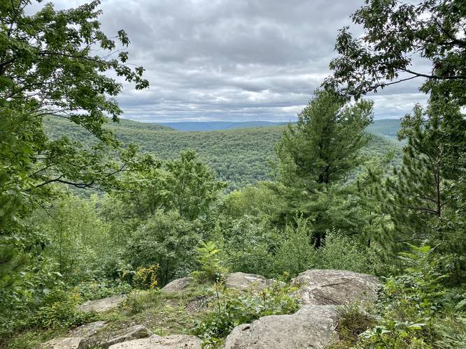
C. Lynn Keller / Bald Hill Scenic Vista - Mile 1.8
At mile 1.8, hikers will reach the scenic vista located on the side of Bald Hill mountain. This rocky outcropping, as of early September 2021, appears to be well-maintained. The vista gives hikers a view of the surrounding mountainsides including the mountain that Stephenhouse Trail and the Archery Trail can be found on. There's a small glimpse of PA Route 287 as well, but there are no views of the lakes unfortunately.
Hiking Down Bald Hill Mountain
After visiting the scenic vista, hikers will want to make their way down Bald Hill mountain and back to parking. Start by hiking back uphill from the vista to the last trail junction - with the trail registry box - and then take a left-hand turn. The first half-mile heading down Bald Hill mountain is not difficult as it follows a fairly modest-grade mountain ridge; however, eventually the trail becomes fairly steep. Making the ~1,000-foot climb down gets more difficult once the trail stops following the mountain ridge and begins following a steeper path along the side of Bald Hill mountain. Take your time and bring trekking poles, if necessary, to aid in the hike down.
Reaching Stephenhouse Road
Around mile 3.3, hikers will reach the Stephenhouse Road Trailhead for the C. Lynn Keller Trail. Here, take a right-hand turn to hike ~0.7-miles back to the parking lot.
Mushrooms
During late Summer hikers may find a plethora of wild mushrooms along this hike. See pictures for more details.
Parking
Hikers will find a small parking lot near the coordinates provided. It's large enough to fit about 5 vehicles.
Pets
Dogs are allowed if leashed and their waste should be carried out by the hiker.
Warnings
Hunting: This trail enters sections of State Game Lands 37, so it's best to wear blaze orange.
Rattlesnakes: This area is known for the Timber Rattlesnake. They're usually found on trails and near rocky outcroppings between late April and early October. Watch your step and give them space when you find one.
Hike Description
This section of the C. Lynn Keller Trail covers the western portion of the trail system, despite there being several more miles of this trail that continue up toward Bald Hill summit, then down and around the mountain to head back to the main trailhead. This track only follows the western portion, heading in a clockwise direction, and uses Stephenhouse Run Road as a connector to complete the loop.
This hike starts out at the main trailhead located along Tioga Hammond Dam Road and follows the left-most yellow-blazed trail as it makes its way up a fairly steep hillside before leveling out a bit. The main trail map at the trailhead is a bit off with regard to cardinal directions and trail overlay, so don't get confused - just stay left and follow the yellow blazes until you reach signage around mile 0.57.
Trail Junction to Vista - Mile 0.57
Around mile 0.57, hikers will reach signage that points towards the scenic vista. Here, stay right as the trail leads hikers up a mostly gradual-sloped hollow. Near the end of this hollow is where the trail becomes more difficult as the elevation grade gets steeper. Once you power through this section, hikers will reach one more junction before finding the scenic vista.
Trail Registry / Top of Bald Hill Mountain Junction - Mile 1.75
Around mile 1.75, hikers will reach the trail registry box for the C. Lynn Keller Trail. Sign in if you care to. More signage can be found here; however, the vista point is located straight ahead and down the fairly steep hill just 0.1-miles away.
C. Lynn Keller / Bald Hill Scenic Vista - Mile 1.8
At mile 1.8, hikers will reach the scenic vista located on the side of Bald Hill mountain. This rocky outcropping, as of early September 2021, appears to be well-maintained. The vista gives hikers a view of the surrounding mountainsides including the mountain that Stephenhouse Trail and the Archery Trail can be found on. There's a small glimpse of PA Route 287 as well, but there are no views of the lakes unfortunately.
Hiking Down Bald Hill Mountain
After visiting the scenic vista, hikers will want to make their way down Bald Hill mountain and back to parking. Start by hiking back uphill from the vista to the last trail junction - with the trail registry box - and then take a left-hand turn. The first half-mile heading down Bald Hill mountain is not difficult as it follows a fairly modest-grade mountain ridge; however, eventually the trail becomes fairly steep. Making the ~1,000-foot climb down gets more difficult once the trail stops following the mountain ridge and begins following a steeper path along the side of Bald Hill mountain. Take your time and bring trekking poles, if necessary, to aid in the hike down.
Reaching Stephenhouse Road
Around mile 3.3, hikers will reach the Stephenhouse Road Trailhead for the C. Lynn Keller Trail. Here, take a right-hand turn to hike ~0.7-miles back to the parking lot.
Mushrooms
During late Summer hikers may find a plethora of wild mushrooms along this hike. See pictures for more details.
Parking
Hikers will find a small parking lot near the coordinates provided. It's large enough to fit about 5 vehicles.
Pets
Dogs are allowed if leashed and their waste should be carried out by the hiker.
Warnings
Hunting: This trail enters sections of State Game Lands 37, so it's best to wear blaze orange.
Rattlesnakes: This area is known for the Timber Rattlesnake. They're usually found on trails and near rocky outcroppings between late April and early October. Watch your step and give them space when you find one.