Loading...

❄️ WINTER SALE! 50% OFF on Supporter Accounts — now through January 31st. Unlock a full year of exclusive website & app perks. Learn More.

Buzzard Rock North Hike

The Buzzard Rock North hike is a short and easy hike that has a great payoff with spectacular vistas from Buzzard Rock. Buzzard Rock is the high point of the cliffs that are visible from Fort Valley. The main rocks area have commanding views to the south through Fort Valley, as well as from the overlook of the Fish Hatchery to the north. The Buzzard Rock cliffs can also be accessed from the south on the Buzzard Rock hike that starts at the Elizabeth Furnace picnic grounds.

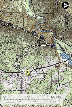
From the Buzzard Rock parking area on Mountain Rd/VA619 follow the white blazed Buzzard Rock Trail as it winds through several small hollows on the lower part of the mountain before becoming more steep and reaching the ridge in 1.5 miles.

From the ridge there are views towards the north and Winchester, as well as to the east and the Front Royal area. There is a small campsite and fire ring at this point but the ground is uneven. The next good campsite on the ridge is in another 1.8 miles, 0.1 miles before the Shawl Gap trail intersection.

Continue on the ridge and in 0.1 miles, the trail will make a short switchback with a climb over a small knoll. In another 0.1 miles after crossing the knoll reach the first of several great overlooks from the Buzzard Rock Cliffs. Follow the cliffs for another 0.3 miles where there are spectacular views of Fort Valley. Turn around at this point. The white Blazed Buzzard Rock Trail continues another 1.8 miles to the intersection of the Shawl Gap and Massanutten Trails.

Explore 91 trails near Front Royal, VA

Know Before You Go

  • Buzzard Rock North hike in Front Royal, VA, is a short and easy 3.8-mile trail with rewarding panoramic views from Buzzard Rock.
  • The trail, marked with white blazes, gradually ascends for 1.5 miles before becoming steeper and reaching the ridge, offering initial views and a small, uneven campsite.
  • Continuing along the ridge for a short distance leads to multiple overlooks along the Buzzard Rock Cliffs, with the best views of Fort Valley located about 0.3 miles beyond the first overlook, marking the recommended turnaround point.
Interactive topographic map for Buzzard Rock North Hike located in Front Royal, VA. Click the "View Map" button to load GPS coordinates and trail markers.
Get directions
Distance
3.8 mi
Difficulty
Moderate
Type
Out-and-Back
Est. Time
1.9 hrs
Elev. Gain
724'
Rating
3.9
Added
January 24, 2025
Updated
April 04, 2025

Weather Forecast

Tonight
Low 41°F
Mostly Cloudy
Wednesday
High 52°F
Light Rain Likely
Wednesday Night
Low 21°F
Light Rain Likely then Slight Chance Light Snow
Thursday
High 30°F
Mostly Sunny
Thursday Night
Low 15°F
Mostly Clear
Friday
High 37°F
Mostly Sunny
Friday Night
Low 26°F
Partly Cloudy
Saturday
High 44°F
Slight Chance Rain And Snow
Saturday Night
Low 20°F
Slight Chance Rain And Snow then Partly Cloudy
Sunday
High 30°F
Mostly Sunny
Sunday Night
Low 16°F
Partly Cloudy
M.L. King Jr. Day
High 36°F
Mostly Sunny
Monday Night
Low 14°F
Partly Cloudy
Tuesday
High 28°F
Sunny
Loading...
Total Change
653'
Ascent
724'
Descent
724'
Loading...

Download the GPX Data for Offline Use

Supporters get exclusive access to download trail routes to the MyHikes app for offline use. Stay prepared on your adventure, even without an internet connection! Become a Supporter today to unlock this feature and hike with confidence.

Download Buzzard Rock North Hike GPX Data to the MyHikes Mobile App

Features

Vista / Lookout Point
Dogs
Mountain Summit
Camping
Water Source

Points of interest

  1. Parking

    38.93773, -78.28855
  2. Main Trailhead

    38.937698, -78.288424

Safety information

For your own safety: plan ahead, let someone know where you'll be, and hike at your own risk.

Hazards

Snakes (Rattlesnakes, Copperheads, others)
Poison Ivy or Poison Oak
Rockfalls, Ledges, or Scrambles

Markers

Blaze Color

White

Availability

All seasons

Surface type

Dirt

Trip Reports (Reviews)

Rated 3.9 out of 5 based on 39 ratings.

Ready to help fellow hikers? Add a trip report to share your experience and provide valuable insights for other hikers!

By: Alexandra
3.8 miles / 6.1 km
May 07, 2017
Hiked out to Buzzard Rock to climb at the top, and the hike was very moderate, even on the "steep" section at the end. The views overlooking the fish hatchery and at the top are incredible, and comparable or better than views from the other side of the valley along the Meneka Peak trail.
Legacy Review
By: michelle
3.8 miles / 6.1 km
March 25, 2017
Warning! The "No Parking" side on the side of the road at the trailhead on route 619 Mountain Rd is bent over and facing the wrong way. Do not park on the side of the road. You will get towed. I got towed because I didn't see the "no parking" sign because it was knocked over facing the wrong way, behind another car that had parked in front of it. If it were not for finding my car gone at the end of the hike, it would have been a perfect day. Thank you to the two wonderful women who had just finished their hike for giving my son and I a lift into Front Royal to pick up my car.
Legacy Review
By: Jamin
3.8 miles / 6.1 km
February 25, 2017
Great Hike! local favorite short hike with big reward check out out the video link below https://www.facebook.com/dronejamin/videos/1845174062364595/
Legacy Review
No community routes found. To add your own hike as a Community Route for this Trail guide, leave a Trip Report with an attached GPX file.

Popular categories

Scenic mountain view representing vista trails
Vista trails
Scenic gorge of cascades representing waterfall trails
Waterfall hikes
Rugged mountain terrain representing summit trails
Summit trails
Scenic mountain view representing dog-friendly trails
Dog-friendly
Scenic campsite with a view representing camping trails
Camping trails
Appalachian Trail logo representing A.T. hikes
A.T. hikes

You May Also Like

25 Best Day Hikes in North Carolina - Discover the top 25 best day hikes in North Carolina, from breathtaking waterfalls to mountain peaks. Explore hidden gems, scenic views, and trails suitable for all skill levels, perfect for your next outdoor adventure.
Explore

25 Best Day Hikes in North Carolina

Discover the top 25 best day hikes in North Carolina, from breathtaking waterfalls to mountain peaks. Explore hidden gems, scenic views, and trails suitable for all skill levels, perfect for your next outdoor adventure.

Read
🍪 We use cookies to learn about site usage and to serve map tiles. You may block cookies manually in the browser. By continuing you agree. Learn more