Loading...

❄️ WINTER SALE! 50% OFF on Supporter Accounts — now through January 31st. Unlock a full year of exclusive website & app perks. Learn More.

Buzzard Rock Hike

The Buzzard Rock hike is a shorter out and back hike in the Elizabeth Furnace section of the GWNF near Front Royal Virginia. There are several other great loop hikes that start from this same area: High Peak, Mudhole Gap, Signal Knob and Meneka Peak. The Shawl Gap Hike also uses this mountain but starts from the other side of the ridge.

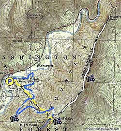
Finding the trail head through the picnic area is a little tricky. From the main parking area take the path from the top left side straight for 100 yards (two other paths cross it) before you arrive at Elizabeth Furnace. Continue around the furnace staying on the blue/orange blazed Tuscarora/Massanutten Trail. Immediately after passing the furnace stay straight DO NOT take the unmarked trail that heads to the right uphill.

Follow the blue/orange blazed Tuscarora/Massanutten Trail and shortly cross a small wooden bridge before starting uphill. The trail will cross a non-maintained yellow blazed trail twice before arriving at the ridge line and four-way trail intersection 2.3 miles from your starting point.

At the ridge and intersection turn left on the white blazed Buzzard Rock Trail is turns uphill for 2.0 miles before reaching Buzzard Rock. The views here are obstructed by trees so for a better vista continue for another 100 yards along the trail where there is a spot that looks out towards Front Royal and the Shenandoah Valley.

To return retrace your steps back down the Buzzard Rock Trail to the four-way intersection. At this point you can either turn right going back down the Tuscarora/Massanutten Trail from where you came or continue straight through the intersection for 25 yards then turning downhill on the old yellow blazed trail.

If you should choose the yellow blazed trail it is considerably shorter as it heads almost straight downhill but therefore very steep as well. This trail is only blazed at the top and before crossing the Tuscarora/Massanutten Trail for the first time, so just stay straight, it will end back at the picnic area.

Explore 92 trails near Fort Valley, VA

Know Before You Go

  • Buzzard Rock is a 7.3-mile out-and-back hike near Front Royal, VA, with the trailhead located within the Elizabeth Furnace picnic area.
  • The hike involves following the blue/orange Tuscarora/Massanutten Trail, then turning left onto the white-blazed Buzzard Rock Trail to reach the rock.
  • An optional, shorter, and steeper yellow-blazed trail can be taken for the return trip, but is not well-maintained.
Interactive topographic map for Buzzard Rock Hike located in Fort Valley, VA. Click the "View Map" button to load GPS coordinates and trail markers.
Get directions
Distance
7.3 mi
Difficulty
Moderate
Type
Out-and-Back
Est. Time
3.7 hrs
Elev. Gain
2,015'
Rating
0.0
Added
January 24, 2025
Updated
April 04, 2025

Weather Forecast

Tonight
Low 41°F
Mostly Cloudy
Wednesday
High 52°F
Light Rain Likely
Wednesday Night
Low 21°F
Light Rain Likely then Slight Chance Light Snow
Thursday
High 30°F
Mostly Sunny
Thursday Night
Low 15°F
Mostly Clear
Friday
High 37°F
Mostly Sunny
Friday Night
Low 26°F
Partly Cloudy
Saturday
High 44°F
Slight Chance Rain And Snow
Saturday Night
Low 20°F
Slight Chance Rain And Snow then Partly Cloudy
Sunday
High 30°F
Mostly Sunny
Sunday Night
Low 16°F
Partly Cloudy
M.L. King Jr. Day
High 36°F
Mostly Sunny
Monday Night
Low 14°F
Partly Cloudy
Tuesday
High 28°F
Sunny
Loading...
Total Change
1,251'
Ascent
2,015'
Descent
2,015'
Loading...

Download the GPX Data for Offline Use

Supporters get exclusive access to download trail routes to the MyHikes app for offline use. Stay prepared on your adventure, even without an internet connection! Become a Supporter today to unlock this feature and hike with confidence.

Download Buzzard Rock Hike GPX Data to the MyHikes Mobile App

Features

Vista / Lookout Point
Dogs
Camping
Water Source

Points of interest

  1. Parking

    38.92787, -78.3294
  2. Main Trailhead

    38.9284, -78.329129

Safety information

For your own safety: plan ahead, let someone know where you'll be, and hike at your own risk.

Hazards

Snakes (Rattlesnakes, Copperheads, others)
Poison Ivy or Poison Oak

Availability

All seasons

Surface type

Dirt

Trip Reports (Reviews)

Your opinion matters! Be the first to rate this trail.

Ready to help fellow hikers? Add a trip report to share your experience and provide valuable insights for other hikers!

No community routes found. To add your own hike as a Community Route for this Trail guide, leave a Trip Report with an attached GPX file.

Popular categories

Scenic mountain view representing vista trails
Vista trails
Scenic gorge of cascades representing waterfall trails
Waterfall hikes
Rugged mountain terrain representing summit trails
Summit trails
Scenic mountain view representing dog-friendly trails
Dog-friendly
Scenic campsite with a view representing camping trails
Camping trails
Appalachian Trail logo representing A.T. hikes
A.T. hikes

You May Also Like

25 Best Day Hikes in North Carolina - Discover the top 25 best day hikes in North Carolina, from breathtaking waterfalls to mountain peaks. Explore hidden gems, scenic views, and trails suitable for all skill levels, perfect for your next outdoor adventure.
Explore

25 Best Day Hikes in North Carolina

Discover the top 25 best day hikes in North Carolina, from breathtaking waterfalls to mountain peaks. Explore hidden gems, scenic views, and trails suitable for all skill levels, perfect for your next outdoor adventure.

Read
🍪 We use cookies to learn about site usage and to serve map tiles. You may block cookies manually in the browser. By continuing you agree. Learn more